Rain and Storms Expected the Second Half of Next Week
NOV. 14, 2025
After a brief taste of chilly temperatures earlier this week, unseasonably mild and humid weather has returned thanks to gusty southerly winds off the Gulf. More late summer-like temperatures and dry weather is expected into the early week. Significant changes in the weather look to occur during the second half of next week.
Friday’s weather maps showed a broad, stable ridge of high pressure in the middle and upper atmosphere stretching from northeastern Mexico to the southern Plains states. The ridge is forecast to remain over Texas into early next week, then finally move off to the east. At the surface, a strong area of high pressure was centered over Mississippi and was helping to bring mild and humid air north from the Gulf. Abundant low-level moisture will likely result in widespread late night and morning low clouds and patchy fog across the region through Tuesday. A strong pressure gradient will likely cause breezy conditions into early next week. Expect wind speeds of 10-15 mph, with occasional gusts to 25 mph.
No rain is forecast through Monday.
Temperatures look to be unseasonably warm and at near record levels through Tuesday.
- High temperatures Friday and Saturday are forecast to generally be in the mid-80s
- High temperatures Sunday and Monday are predicted to be in the upper 80s, with middle 80s expected towards the coast
- High temperatures Tuesday are forecast to be in the mid and upper 80s
- Low temperatures Saturday through Wednesday mornings will range from the upper 50s to low 60s across the Hill Country, to the mid and upper 60s near the coast
Some small changes in the weather are forecast to take place on Tuesday as the ridge over Texas weakens and weak wave of low pressure tracks northeast across the Panhandle region. Increasing moisture ahead of the trough and less stability from the ridge may allow for the development of a couple of spotty rain showers across the region. The chance for rain will be less than 20 percent. Rain amounts, if any, should only amount to a few hundredths.
Next Wednesday through Friday, the weather pattern is forecast to trend wetter and more unsettled as a Pacific trough of low pressure digs into the Desert Southwest and tracks east-northeast across Texas. With the trough taking a more southerly path and abundant moisture in place, conditions look favorable for the development of several rounds of rain showers and scattered thunderstorms Wednesday into Friday. Thursday is expected to have the best chance for rain and thunderstorms. Given the highly dynamic nature of this approaching trough, some of the storms could be strong to severe. In addition, some of the storms could be capable of producing areas of moderate to heavy rain. As of today, there remains quite a bit of uncertainty regarding timing, intensity, and location of the heaviest precipitation. These details should become clearer over the next few days as the forecast model solutions begin gto converge.
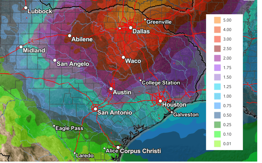
The National Weather Service’s rainfall forecast from midday Friday shows the highest totals from this system will occur across the northern Hill Country and the northern half of Central Texas (including the Austin metro). Here, totals of 1-2 inches are predicted. For the remainder of Central Texas and the middle Texas coast, totals of 1-1.5 inches are forecast.
NWS Rainfall Forecast Valid through 6 pm next Friday:
The rain is expected to end from west to east next Friday as the trough exits to the northeast. A Pacific front associated with the trough will move across the area next Thursday, bringing slightly cooler air for Friday and next weekend. Expect high temperatures to fall to the 70s, with lows dropping to the upper 40s to low 50s.
Taking a peek into the week of November 24th, forecasts call for temperatures to be seasonable, with highs generally in the 70s. We may see another chance for rain during the first half of week as another Pacific trough of low pressure approaches from the west.
Tropical Weather Update
Weather conditions remain quiet across the Atlantic basin and tropical cyclone development is not expected over the next seven days.
Update on La Niña
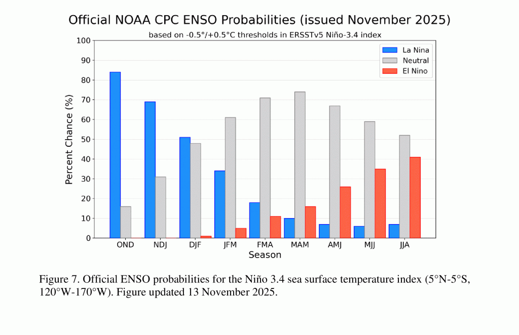
The Climate Prediction Center issued their November climate update Thursday and forecasters indicated a weak La Niña should continue through January. La Niña is forecast to weaken sometime in January or early February, with a transition back to ENSO-neutral conditions taking place sometime in February or March. ENSO-neutral conditions are forecast to continue through spring and early summer.
It’s worth pointing out the probability for the development of El Nino has increased to near 40 percent for late spring or next summer. Stay tuned for additional updates.
Have a great weekend!
Bob
Social Media