Rain and Thunderstorms Expected through Wednesday. Conditions Trending Drier Late Week
April 20, 2026
Rain showers and scattered thunderstorms developed across the Edwards Plateau and parts of West Texas Sunday night as a small wave of low pressure pushed east out of northern Mexico. The rain expanded east to cover the Hill Country and Central Texas regions Monday morning into Monday afternoon. According to LCRA’s Hydromet and Doppler radar estimates as of midday Monday, the highest totals so far have occurred over the area from southwest of San Angelo, southeast to Junction and Kerrville. Here totals of 1-2 inches have been recorded. Totals of 4-5 inches have been estimated to have occurred over southeastern Schleicher County, to the southeast of Eldorado. For most other locations, totals have generally been less than a half inch.
Periods of rain showers and scattered thunderstorms are forecast across the entire region Monday afternoon and Monday night as the approaching trough of low pressure creates a favorable setup for light to moderate overrunning rain. The threat for any strong to severe storms will be low. Lows Tuesday morning will range from the mid-50s across the Hill Country to the low 60s near the coast.
Additional showers and thunderstorms are forecast to develop across the northern Mexico and the Rio Grande Plains Monday evening in response to a second trough of low pressure pushing to the east out of northern Mexico. High resolution forecasts call for this activity to spread to the east-northeast through the Hill Country, Central Texas, and coastal regions late Monday night into Tuesday morning. There appears to be some potential for some of the rain to train over the same areas during this period, which could lead to higher totals. Overall, this rain is predicted to be a bit heavier in intensity, compared to Monday’s rain. With the ground wet from recent rain, some localized flooding will be possible.
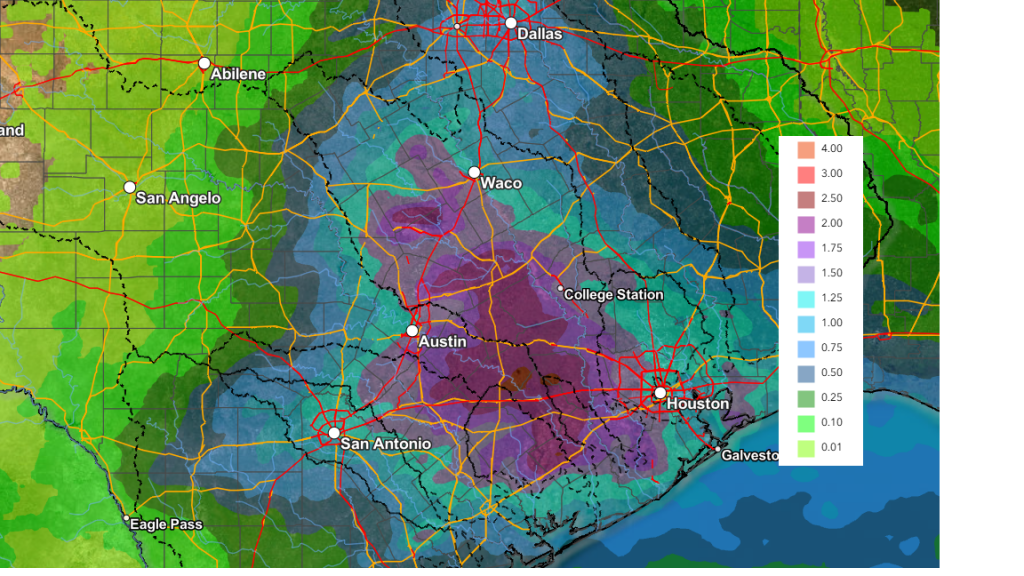
Tuesday afternoon into Tuesday night, the most favorable area for rain and thunderstorms will be east of Interstate 35 as the upper trough lifts northeast to Oklahoma. There will be a 20-30 percent chance for additional showers and thunderstorms across the Hill Country, and a 30-40 percent chance for showers for areas along and east of I-35. Totals Monday night through Tuesday night are forecast to generally average between 1 and 3 inches, with a couple of isolated totals to near 4 inches possible. High temperatures Tuesday are predicted to be in the upper 60s.
Additional scattered showers and thunderstorms look to continue across the region Wednesday as a moist and unstable atmosphere persists over the region. The highest probability for rain (40-50 percent) will be for areas east of I-35, while the chance for rain across the Hill Country will only be near 20-30 percent. Rain amounts Wednesday look to range from 0.25 to 0.5 inches across the coastal plains, to less than a quarter inch across the Hill Country. The temperature will be warmer, with highs around 80-82 degrees.
WPC’s 2-day Rainfall Forecast Valid through 7 pm Wednesday:
Dry weather is forecast Thursday and Friday as a weak ridge of high pressure sets up over Texas. Expect a partly to mostly cloudy sky both days. High temperatures are predicted to be in the mid and upper 80s.
For the upcoming weekend, forecasters will be monitoring West Texas where a few thunderstorms may develop along the dry line each afternoon. A couple of these storms could track as far east as the Hill Country region in the evening and early nighttime periods. There will be a potential for some of these storms to become severe. Otherwise, weather conditions are shaping up to be partly cloudy and warm. High temperatures will continue in the mid and upper 80s.
Looking ahead to next week, forecasts are calling for generally dry weather Monday and Tuesday. There will be a slight chance for afternoon showers and thunderstorms next Wednesday through Friday. Rain amounts next week are not expected to be very high. There are indications for a somewhat better chance for rain developing next weekend.
Have a great week!
Bob
Social Media