

Rain Ending on Saturday. Another Chance for Rain and Storms Monday Night into Tuesday
OCT. 30, 2026
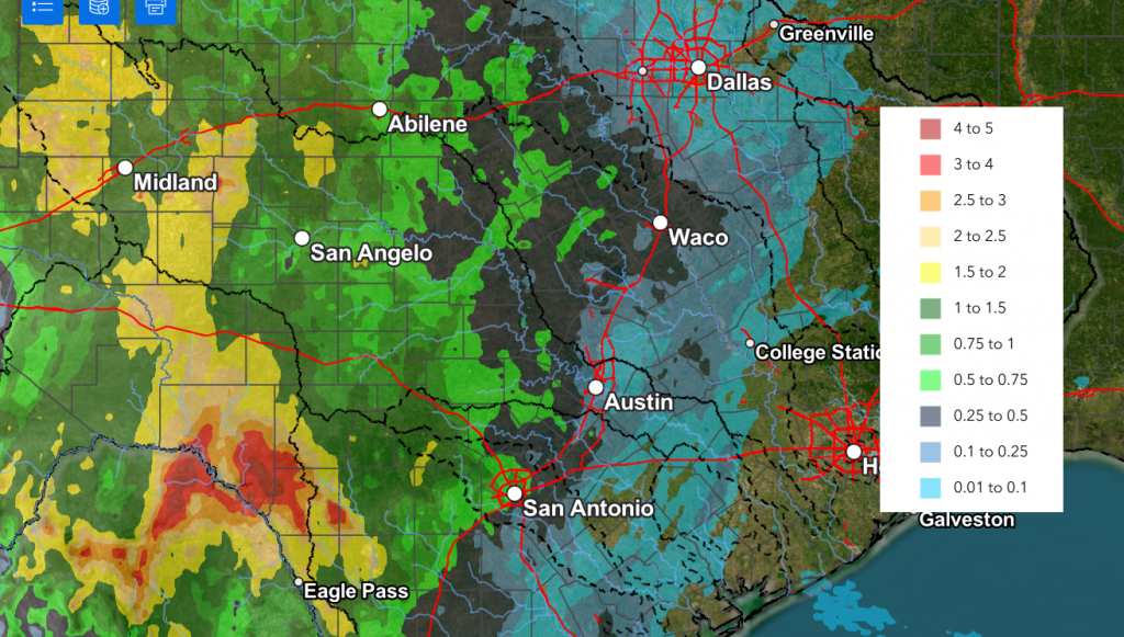
A wet and unsettled weather pattern took shape across the western half of Texas Thursday and Thursday night as considerable Gulf and Pacific moisture spread into the state ahead a trough of low pressure lifting north out of Mexico. Through 7 am Friday morning, the highest totals of rain have occurred over the area between Midland, Ozona, and Del Rio. Doppler Radar estimates show totals of 2-5 inches occurred over the area between Del Rio and Brackettville. Across the Hill Country, LCRA’s Hydromet showed totals through 11 am of just over an inch over the area between Rocksprings, Junction, and Mason. Further east, totals have been just under a half inch across the eastern Hill Country, and under a quarter inch along the Interstate 35 corridor.
NWS Estimate of Rain Falling Between 7 am Thursday and 7 am Friday:
The cloudy, wet pattern is forecast to continue Friday into Saturday as the trough over Mexico slowly tracks to the northeast. With abundant moisture in place, waves of light to moderate rain showers are predicted across the entire region. The highest probability for rain (near 100 percent) through Friday night will be across the western half of the Hill Country where the rain looks to be more persistent. For the eastern Hill Country, Central Texas, and coastal region, the probability for rain will be near 50 percent. Atmospheric instability will remain low so the threat for any severe storms will be quite low. Periods of mostly light rain are forecast to continue across the region Saturday morning. The chance for rain is expected to diminish Saturday afternoon as the tough finally exits to the northeast. A mostly cloudy to party cloudy ski is forecast Saturday afternoon.
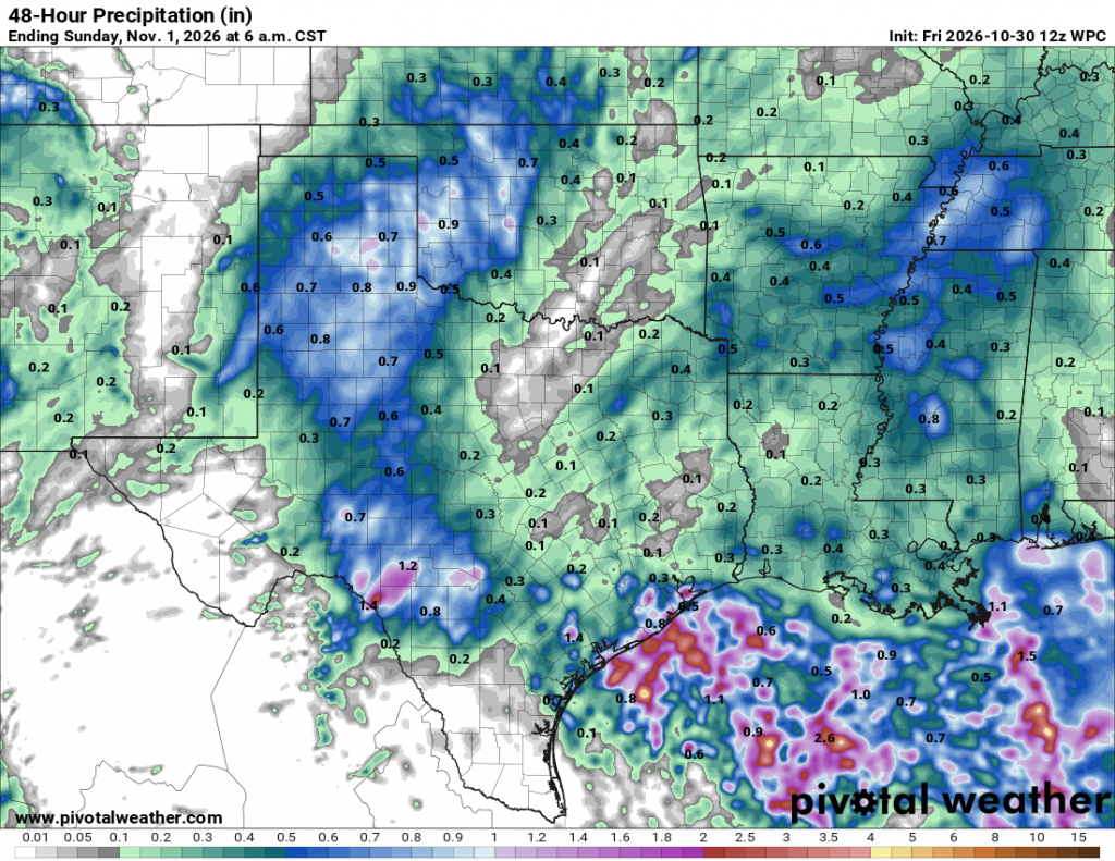
The National Weather Service rainfall forecast through Saturday calls for additional totals to be between 0.5 and 1 inch across the western Hill Country, and less than a half inch at most other locations. The NWS has placed Schleicher, Sutton, Kimble, and Edwards Counties under a Flood Watch through late Friday afternoon. Here, additional totals of 2-4 inches will be possible.
NWS Rainfall Forecast Valid through 6 am Sunday:
- High temperatures Friday will range from the mid-60s across the western Hill Country, to around 70 degrees in the Austin area, to near 80 degrees along the middle Texas coast
- High temperatures Saturday will range from the low 70s across the Hill Country, to the upper 70s across Central Texas, to the middle 80s near the coast
For Saturday evening (Halloween), weather conditions are forecast to be rain-free during the typical trick-or-treating window. Expect the temperature to generally be in the low 70s.
Partly cloudy and warmer weather will make a return for Sunday and Monday as a weak ridge of high pressure spreads over Texas in the wake of Saturday’s storm system. High temperatures both days are forecast to be near 78-82 degrees across the Hill Country, and in the mid-80s at most other locations.
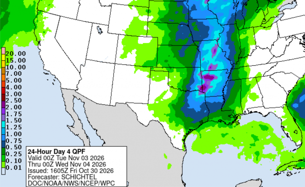
A chance for rain showers and thunderstorms will return to the forecast Monday night into Tuesday when a Pacific cold front is forecast to push east across the state. The front is predicted to spread across the Hill Country late Monday night, then sweep east across Central Texas and the middle Texas coast Tuesday morning. The front should push off the coast Tuesday afternoon. Forecasts call for the atmosphere ahead of the front to be quite moist and moderately unstable. A broad line of showers and thunderstorms is predicted to develop just ahead of and along the cold front as it moves to the east. There are even some signals a few of the storms may be strong to severe. The chance for rain should end across the Hill Country and Central Texas regions Tuesday morning and across the coastal region Tuesday afternoon.
Rain amounts from the line of storms is forecast to generally average between 0.25 and 0.5 inches. Some isolated totals will be possible.
NWS Rainfall Forecast for the Period 6 pm Monday through 6 pm Tuesday:
Gusty north and northwesterly winds and slightly cooler air will follow the cold front Tuesday afternoon and Tuesday night. Sunny, dry, and cooler weather is expected next Wednesday through Friday.
- High temperatures next Wednesday are forecast to be mostly in the mid and upper 70s
- Lows Wednesday through Saturday will range from the upper 40s across the Hill Country, to the low 50s across Central Texas, to the mid-50s across the coastal region
Longer-range forecasts call for a slight chance for rain for next weekend.
Tropical Weather Outlook
Weather conditions are quiet across the tropical Atlantic. There are no systems in place which pose a threat for tropical development over the next seven days.
Time Change Reminder
Saturday night is Halloween, but it’s also time change. Daylight saving time will end at 2 am Sunday morning, Nov. 1. At the time, we will “fall backward” and set our clocks back one hour. The change marks the return to standard time and gives Americans an extra hour of sleep. It also brings earlier sunsets and more morning daylight as winter approaches.
Have a great weekend!
Bob
Social Media