

Rain Increasing Saturday into Sunday. Cooler Monday through Tuesday
NOV. 13, 2026
There will be several changes in the weather over the next few days as conditions become wet and unsettled conditions develop this weekend, then move back to dry and cooler early next week. The temperature looks to fall to mid and upper 40s Sunday night and Monday night, but no unusually cold temperatures are forecast over the next week to ten days.
…For Friday and Friday Night…
Sunny, tranquil, mild fall weather is expected Friday as a weak ridge of high pressure spreads over the state. At the surface, a backdoor cold front pushing south through the area will bring slightly cooler air to the region.
- Friday’s temperature is forecast to reach the mid-70s at most locations
- Lows Saturday morning will range from the upper 40s across the Hill Country, to the low and mid-50s across the coastal plains
…Saturday…
Saturday’s weather will feature more clouds and a chance for scattered rain showers by the afternoon. Forecasts call for a large trough of low pressure to push into Far West Texas and the Panhandle region on Saturday that will pull considerable moisture north from the Gulf. The trough is predicted to move southeast during the day on Saturday, creating atmospheric conditions that will result in the development of rain showers. Light rain showers are forecast to develop across the Edwards Plateau region Saturday morning, with the showers spreading east across the Hill Country and the Interstate 35 corridor Saturday afternoon into Saturday evening. The showers are forecast to spread over the coastal region after midnight Saturday night. The chance for rain Saturday night across the region will be near 60 percent. Rain amounts through daybreak Sunday morning are forecast to generally average between 0.25 and 0.5 inches.
There will be several changes in the weather over the next few days as conditions become wet and unsettled conditions develop this weekend, then move back to dry and cooler early next week. The temperature looks to fall to mid and upper 40s Sunday night and Monday night, but no unusually cold temperatures are forecast over the next week to ten days.
…For Friday and Friday Night…
Sunny, tranquil, mild fall weather is expected Friday as a weak ridge of high pressure spreads over the state. At the surface, a backdoor cold front pushing south through the area will bring slightly cooler air to the region.
- Friday’s temperature is forecast to reach the mid-70s at most locations
- Lows Saturday morning will range from the upper 40s across the Hill Country, to the low and mid-50s across the coastal plains
…Saturday…
Saturday’s weather will feature more clouds and a chance for scattered rain showers by the afternoon. Forecasts call for a large trough of low pressure to push into Far West Texas and the Panhandle region on Saturday that will pull considerable moisture north from the Gulf. The trough is predicted to move southeast during the day on Saturday, creating atmospheric conditions that will result in the development of rain showers. Light rain showers are forecast to develop across the Edwards Plateau region Saturday morning, with the showers spreading east across the Hill Country and the Interstate 35 corridor Saturday afternoon into Saturday evening. The showers are forecast to spread over the coastal region after midnight Saturday night. The chance for rain Saturday night across the region will be near 60 percent. Rain amounts through daybreak Sunday morning are forecast to generally average between 0.25 and 0.5 inches.
- High temperatures Saturday are predicted to be in the mid and upper 60s
- Lows Sunday morning will range from the low 50s across the Hill Country, to the low 60s across the coastal plains
…Sunday…
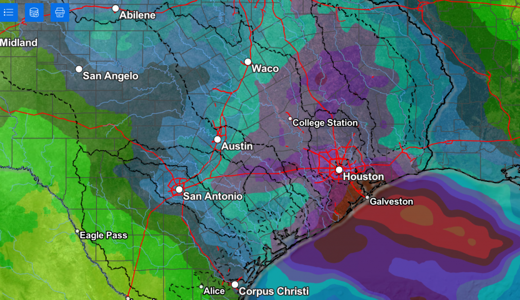
Frequent periods of light to moderate rain showers and scattered thunderstorms are forecast across the region Sunday as deeper moisture spreads in ahead of the upper trough. The probability for rain is forecast to be near 90-100 percent across the region. The rain is forecast to slowly taper off from west to east across the Hill Country and Central Texas regions Sunday evening. Rain amounts Sunday are forecast to generally total between a quarter and a half inch across the western Hill Country, and totals of 0.75 to 1.25 inches across the eastern Hill Country and the Austin/Interstate 35 corridor. The eastern half of Central Texas could see totals of 1-2 inches. A Pacific cold front is predicted to track east across the region late Sunday afternoon into Sunday evening, bringing in drier and slightly cooler air for Sunday night and Monday.
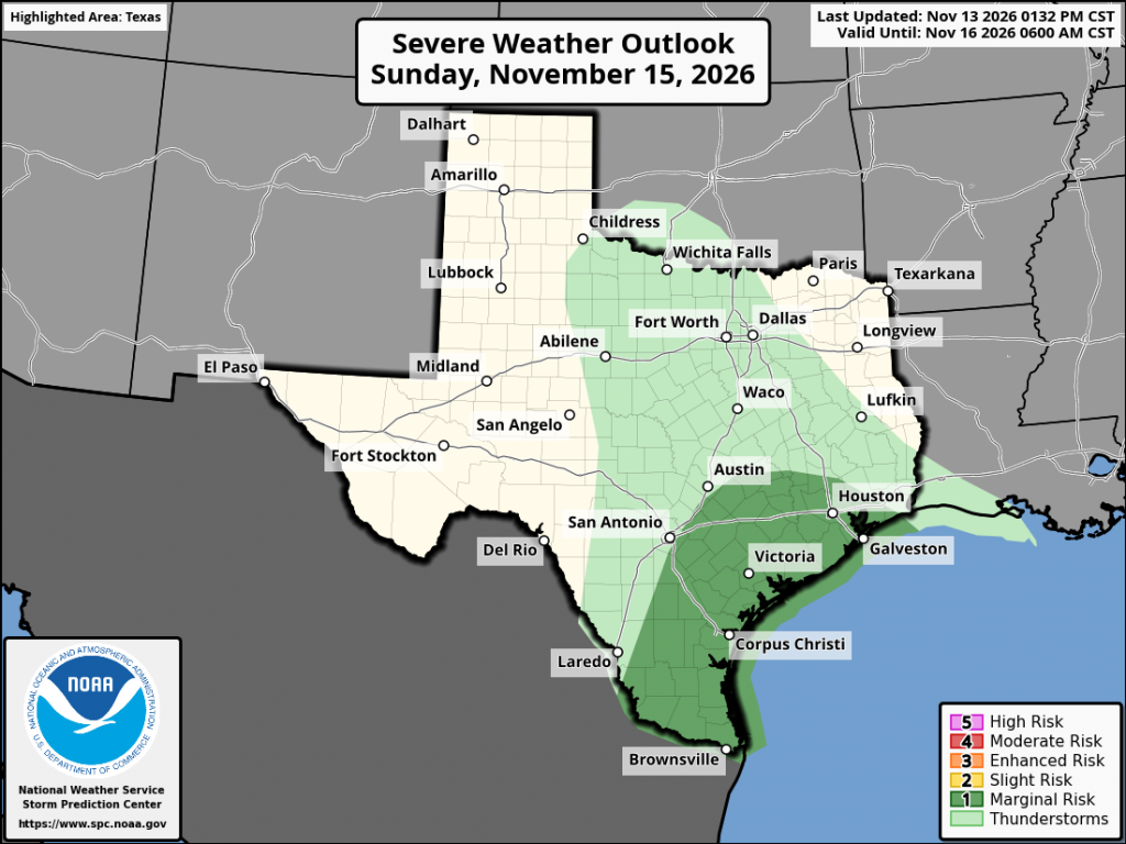
The middle Texas coast along with Southeast Texas appears to have the highest potential for higher totals of rain and possibly some severe storms as this area will be in a warm, moist sector ahead of the approaching cold front. The Storm Prediction center has placed the middle Texas coast and the southeastern counties of Central Texas under a Marginal, or 1 out of 5 risk, for severe thunderstorms Sunday and Sunday night. Severe weather threats will include, damaging winds, large hail, and perhaps a brief tornado. Totals across the coastal plains through 6 am Monday are forecast to generally average between 1 and 3 inches.
Rainfall Forecast for the Period 6 pm Friday through 6 pm Monday:
Cooler and drier air is forecast to spread over the region behind Sunday’s Pacific cold front. Monday is actually shaping up to be somewhat chilly as widespread clouds will limit the temperature from warming above 60 degrees. Moisture trapped in the frontal inversion is expected to keep widespread clouds over the area through Tuesday morning. A few sprinkles of light rain even will be possible Monday afternoon. The clouds are forecast to slowly thin on Tuesday, leading to a partly to mostly cloudy sky.
- Lows Monday and Tuesday mornings will include the upper 40s across the Hill Country and Central Texas regions, and in the low to mid-50s across the coastal region
- High temperatures Monday and Tuesday are predicted to be in the mid and upper 50s
…Next Wednesday through Friday…
Forecasts call for mostly cloudy conditions to be in place across the region as another Pacific trough of low pressure slowly pushes east from the West Coast, causing moisture to return from the Gulf. A slight chance for rain is forecast next Wednesday and Thursday. A somewhat better chance for rain will be possible late next week into next weekend. High temperatures Wednesday through Friday are predicted to be in the upper 60s to low 70s. Lows are predicted to be in the 50s to low 60s.
Tropical Weather Outlook
Weather conditions are quiet across the tropical Atlantic and tropical cyclone development is not forecast over the next seven days.
El Niño Update
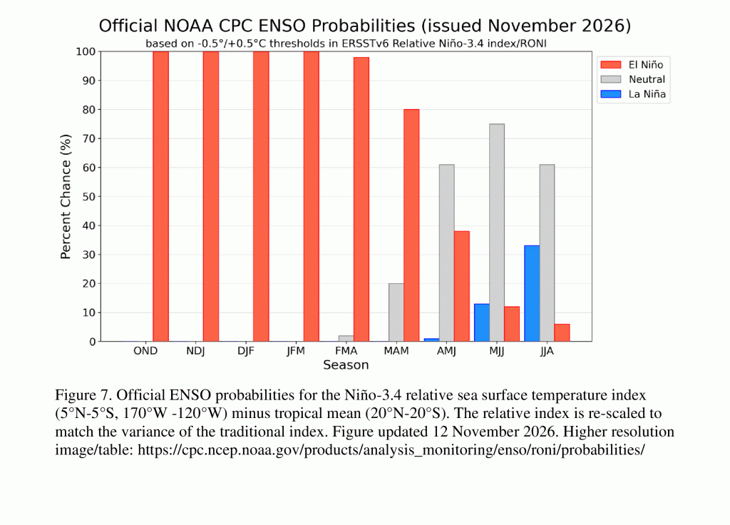
NOAA’s Climate Prediction Center issued their monthly update on El Niño Thursday. According to the update, El Niño continues to strengthen, with a strong-to-very strong El Niño likely to persist through January-March 2027 (remaining greater than a 79% chance). The CPC Official ENSO outlook, which synthesizes multiple models from North America and abroad, indicates El Niño will continue to strengthen before beginning to weaken in early 2027. Chances for a historic event exceeding previous El Niños dating back to 1950 (+2.5°C or more for a 3-month RONI value) are now ~60% for the October-December and November-January periods, remaining at better than even odds.
The outlook called for El Niño to end, with the Pacific returning to a neutral state in the late spring and the Pacific remaining neutral through next summer.
Have a great weekend!
Bob
- High temperatures Saturday are predicted to be in the mid and upper 60s
- Lows Sunday morning will range from the low 50s across the Hill Country, to the low 60s across the coastal plains
…Sunday…
Frequent periods of light to moderate rain showers and scattered thunderstorms are forecast across the region Sunday as deeper moisture spreads in ahead of the upper trough. The probability for rain is forecast to be near 90-100 percent across the region. The rain is forecast to slowly taper off from west to east across the Hill Country and Central Texas regions Sunday evening. Rain amounts Sunday are forecast to generally total between a quarter and a half inch across the western Hill Country, and totals of 0.75 to 1.25 inches across the eastern Hill Country and the Austin/Interstate 35 corridor. The eastern half of Central Texas could see totals of 1-2 inches. A Pacific cold front is predicted to track east across the region late Sunday afternoon into Sunday evening, bringing in drier and slightly cooler air for Sunday night and Monday.
The middle Texas coast along with Southeast Texas appears to have the highest potential for higher totals of rain and possibly some severe storms as this area will be in a warm, moist sector ahead of the approaching cold front. The Storm Prediction center has placed the middle Texas coast and the southeastern counties of Central Texas under a Marginal, or 1 out of 5 risk, for severe thunderstorms Sunday and Sunday night. Severe weather threats will include, damaging winds, large hail, and perhaps a brief tornado. Totals across the coastal plains through 6 am Monday are forecast to generally average between 1 and 3 inches.
Rainfall Forecast for the Period 6 pm Friday through 6 pm Monday:
…Monday and Tuesday…
Cooler and drier air is forecast to spread over the region behind Sunday’s Pacific cold front. Monday is actually shaping up to be somewhat chilly as widespread clouds will limit the temperature from warming above 60 degrees. Moisture trapped in the frontal inversion is expected to keep widespread clouds over the area through Tuesday morning. A few sprinkles of light rain even will be possible Monday afternoon. The clouds are forecast to slowly thin on Tuesday, leading to a partly to mostly cloudy sky.
- Lows Monday and Tuesday mornings will include the upper 40s across the Hill Country and Central Texas regions, and in the low to mid-50s across the coastal region
- High temperatures Monday and Tuesday are predicted to be in the mid and upper 50s
…Next Wednesday through Friday…
Forecasts call for mostly cloudy conditions to be in place across the region as another Pacific trough of low pressure slowly pushes east from the West Coast, causing moisture to return from the Gulf. A slight chance for rain is forecast next Wednesday and Thursday. A somewhat better chance for rain will be possible late next week into next weekend. High temperatures Wednesday through Friday are predicted to be in the upper 60s to low 70s. Lows are predicted to be in the 50s to low 60s.
Tropical Weather Outlook
Weather conditions are quiet across the tropical Atlantic and tropical cyclone development is not forecast over the next seven days.
West Texas Weather Outlook
- Showers and a slight chance for thunderstorms is forecast Friday evening through midday Saturday
- There will be a 50 percent chance for showers and isolated thunderstorms Saturday night through early Sunday morning
- Sunny weather is forecast Sunday afternoon
- Mostly cloudy conditions are forecast next week
- Temperatures will remain cool Monday and Tuesday but warm some Wednesday through Friday
El Nino Update
NOAA’s Climate Prediction Center issued their monthly update on El Niño Thursday. According to the update, El Niño continues to strengthen, with a strong-to-very strong El Niño likely to persist through January-March 2027 (remaining greater than a 79% chance). The CPC Official ENSO outlook, which synthesizes multiple models from North America and abroad, indicates El Niño will continue to strengthen before beginning to weaken in early 2027. Chances for a historic event exceeding previous El Niños dating back to 1950 (+2.5°C or more for a 3-month RONI value) are now ~60% for the October-December and November-January periods, remaining at better than even odds.
The outlook called for El Niño to end, with the Pacific returning to a neutral state in the late spring and the Pacific remaining neutral through next summer.
Have a great weekend!
Bob
Social Media