Rounds of Rain and Strong to Severe Storms Will Continue through the Weekend
May 3, 2024
Key Messages:
- A wet and unsettled weather pattern will continue through the weekend
- Thunderstorms developing across West Texas Friday afternoon may spread east across parts of the Hill Country and Central Texas Friday evening and Friday Night
- Some of these storms could produce large hail and damaging winds
- Confidence is increasing in more widespread, impactful rain and thunderstorms to spread southeast into the northern half of the Hill Country and Central Texas late Saturday afternoon and Saturday night
- Late hail, damaging winds, and moderate to heavy rain will be possible
- Periods of showers and scattered thunderstorms are forecast across the entire region through Sunday afternoon
- A generally dry weather pattern is forecast to take hold on Monday
Discussion
An active and potentially stormy weather pattern is expected to continue trough the weekend.
There will be a 20-30 percent chance for some widely scattered rain showers and isolated thunderstorms across the region Friday afternoon. Expect high temperatures to generally be in the low and mid-80s.
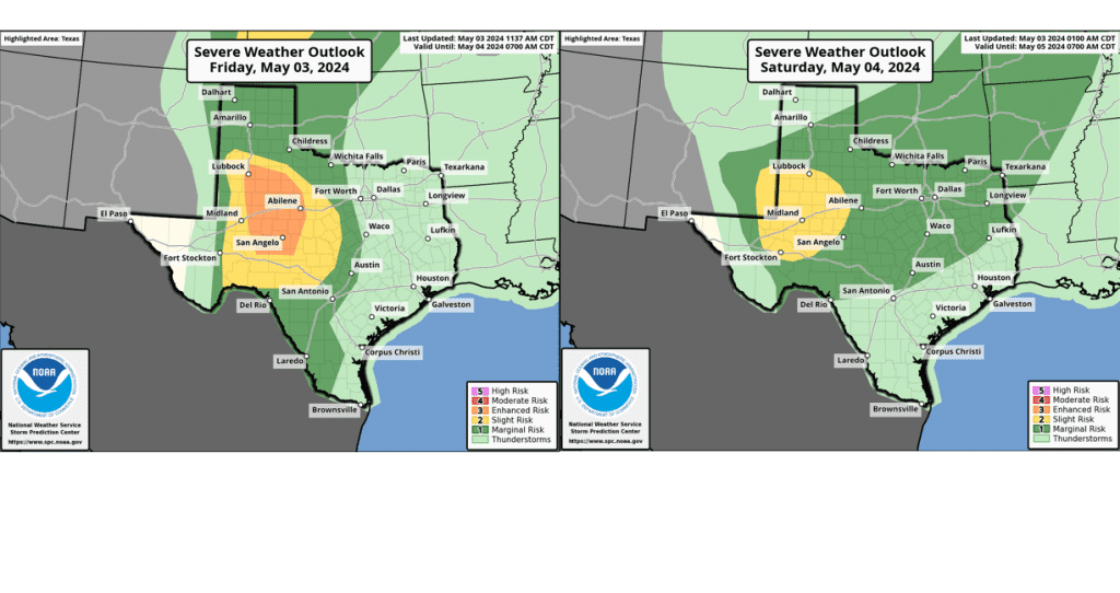
Forecasters will be keeping a close watch across West Texas late this afternoon as atmospheric conditions will be favorable for thunderstorms to develop along the West Texas dry line. Scattered thunderstorms are forecast to develop and quickly become severe over the area from southeast of Lubbock, to west of San Angelo, to near Del Rio. Storm Prediction Center forecasters state these storms will have the potential to produce large to giant size hail (max size 3-4+ inches in diameter), a few tornadoes, and severe wind gusts across the Texas South Plains extending southeastward into portions of the Big Country Friday evening.
High resolution forecasts call for the area of storms to spread east across the Edwards Plateau and Hill Country regions Friday evening. Some of the storms could even reach the Austin and Interstate 35 corridor sometime late Friday evening and toward midnight. The primary severe weather threats will primarily be large hail, damaging downburst winds, and locally heavy rain. The thunderstorms activity is expected to diminish shortly after midnight.
The Storm Prediction Center has placed the Hill Country under a Slight Risk, or 2 out of 5 risk, for severe thunderstorms through Friday Night. The Intestate 35 corridor has been placed under a 1 out 5 risk for severe thunderstorms.
Rainfall from Friday evening’s storms developing storms is forecast to average between 0.5 and 1 inch, with isolated totals of 1-2 inches possible.
Saturday
Several of the forecast solutions are keying in on a trough of low pressure that will be moving into West Texas Saturday afternoon. The solutions call for a large area of rain showers and thunderstorms to develop across Northwest and West Central West Texas Saturday afternoon. This activity is then predicted to spread east-southeast across the northern half of the Hill Country and the northern half of Central Texas, including the Austin area, Saturday evening. Some of the rain and storms may spread further south into the Hill Country and Central Texas late Saturday evening into Saturday night. Once again, some of these storms could be severe, with the primary severe weather threats being large hail, damaging winds and locally heavy rain. The Storm Prediction Center has placed the Hill Country and the I-35 corridor under a Marginal, or 1 out or 5 risk, for severe storms through Saturday night. (See the severe weather outlook map for Saturday above)
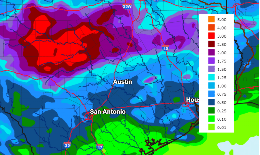
Rain amounts Saturday through Sunday morning are forecast to generally average between 1 and 2 inches across the northern half of the Hill Country and Central Texas. For areas to the south, totals of around a half inch are forecast.
Sunday
Forecasts call for additional waves of rain showers and scattered thunderstorms to spread across the region Sunday morning through Sunday afternoon. The probability for rain will be near 50-60 percent. Expect rain amounts to average between 0.25 and 0.5 inches. The rain and thunderstorms are forecast to taper off Sunday evening.
Rain amounts between Friday evening and Monday evening are forecast to average between 1 and 4 inches across the northern Hill Country, and between 1 and 2 inches for the northern counties of Central Texas, including Austin. For areas to the south, rain amounts will average between 0.25 and 1 inch.
NWS Rainfall Forecast for the Period 7 pm Friday through 7 pm Monday:
Next Week
The recent wet weather pattern is predicted to diminish by Monday as a ridge of high pressure spreads over Texas out of Mexico. A partly to mostly cloudy sky is forecast Monday. Tuesday through Thursday will see a mostly sunny sky. High temperatures next Tuesday through Thursday are forecast to generally be in the low to mid-90s. Highs are forecast to lower back to the mid-90s next Friday when a “cold” front sinks south across the area.
Bob
Social Media