Saturday Update on the Winter Storm and Arctic Chill
JAN. 24, 2026
- The National Weather Service has posted an Ice Storm Warning for a large part of the Hill Country and the Austin/Interstate 35 Corridor until noon Sunday
- A Winter Storm Warning remains posted for all other locations through noon Sunday
- An Extreme Cold Warning is in effect through noon Monday.
- Significant travel impacts appear likely across the region and the state Saturday night through Sunday
Arctic air spread south across the Hill Country Central Texas Friday night. As of mid-afternoon Saturday, the temperature was below freezing for areas north of Interstate 10. These below freezing temperatures will continue Saturday night through Sunday night.
Weather conditions are expected to deteriorate across the region Saturday night as a trough of low pressure over northern Mexico tracks east and moves over Texas. Increasing lift from this system is expected to result in the development of bands of light to moderate precipitation. The precipitation is forecast to begin across the Edwards Plateau/western Hill Country Saturday and spread east to Central Texas and the middle Texas coast overnight. This episode of precipitation will likely bring the highest quantities of freezing rain and sleet to much of South-Central Texas, compared to what occurred early Saturday.
For the Hill Country and Austin/Interstate 35 corridor, a mix of freezing rain and sleet can be expected Saturday night. For locations east of Interstate 35, the precipitation is expected to mainly be in the form of freezing rain, along with some occasional sleet.
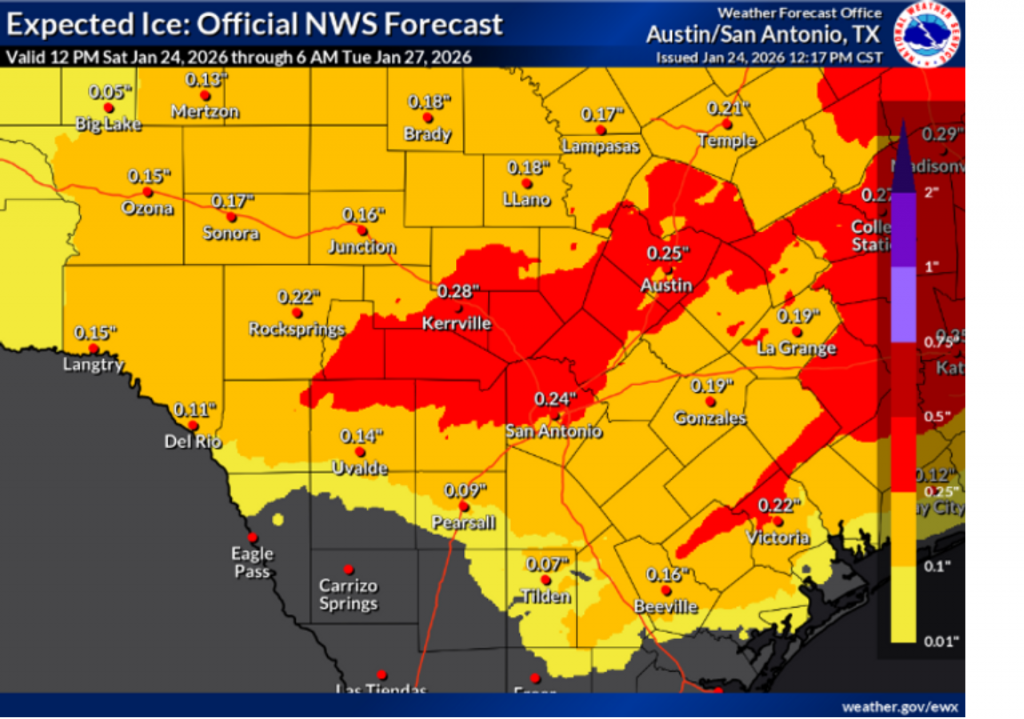
The National Weather Service is highlighting the eastern and southern Hill Country counties along with the I-35 corridor between Georgetown and New Braunfels and has posted an Ice Storm Warning through noon Sunday. Here, widespread ice accumulation of ¼ inch, with isolated totals to around a half inch are forecast. This particular area saw some significant totals of rain Friday night. Residual water from these rain may enhance the amount of ice developing from the overnight precipitation.
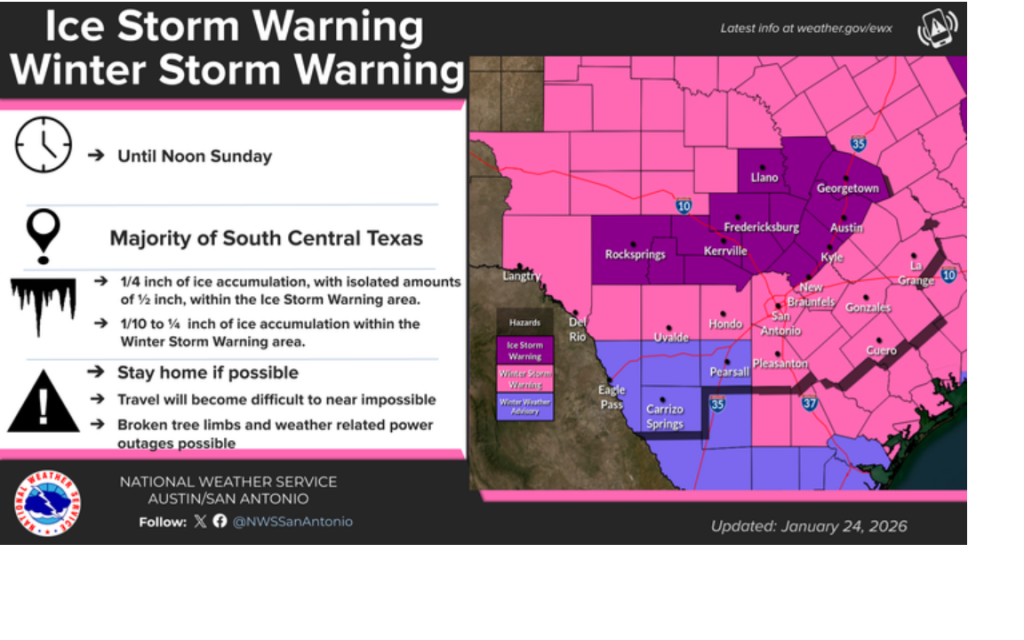
For most other locations, including the coastal counties, ice accumulations are forecast to average between 1/10th and ¼ of an inch. A Winter Storm Warning has been posted for the rest of the region until noon Sunday.
A few snow flurries will be possible towards the tail end of the precipitation event Sunday morning, but snow accumulations are forecast to be negligible compared to that of ice and sleet. All the precipitation is predicted to exit the area by noon Sunday. Some scattered sunshine should start to filter in from the west by Sunday afternoon.
Hazardous travel conditions are expected to be in place all of Sunday as the temperature is not expected to climb above freezing across the Hill Country and Central Texas regions. Across the coastal area, the temperature may warm into the mid-30s for a couple of hours Sunday afternoon, but readings will fall back below freezing Sunday evening. While the scattered sunshine may help reduce some ice, icing concerns will likely continue into Monday as the temperature stays below freezing.
Sunny and dry weather is predicted Monday through Thursday. However, the temperature is expected to remain colder than average throughout the coming week. Extremely cold temperatures are forecast Sunday night and again Monday night. Lows both nights are predicted to be in the single digits and teens across the Hill Country, and in the teens across the rest of the region. High temperatures Monday are forecast to only be in the mid and upper 30s. High temperatures Tuesday look to be in the mid-40s, warming to the upper 40s and low 50s Thursday.
There is considerable uncertainty in the forecast for late week. Some of the forecast solutions call for another trough of low pressure to move over the area at that time. Given the very cold temperatures aloft, this could result in the development of some mixed or wintry precipitation across the region. Stay tuned for more details as the computer models get a better handle on the next system.
Bob
Social Media