Severe Thunderstorm Watch for Central Texas Thursday Afternoon and Evening
May 1, 2025
The National Weather Service has posted a Severe Thunderstorm Watch for the a portion of the Hill Country and Central Texas until 9 pm Thursday evening. The watch includes the Travis County/Austin metro area.
National Weather Service forecasters are closely monitoring the Hill Country and Central Texas regions this afternoon where the atmosphere has become quite moist and fairly unstable. With the temperature already approaching 90 degrees, isolated but intense thunderstorms are expected to develop across the area.
Today’s primary severe weather threats will include:
- Scattered large hail and isolated very large hail up to 2.5 inches in diameter
- Scattered damaging wind gusts to 70 mph likely
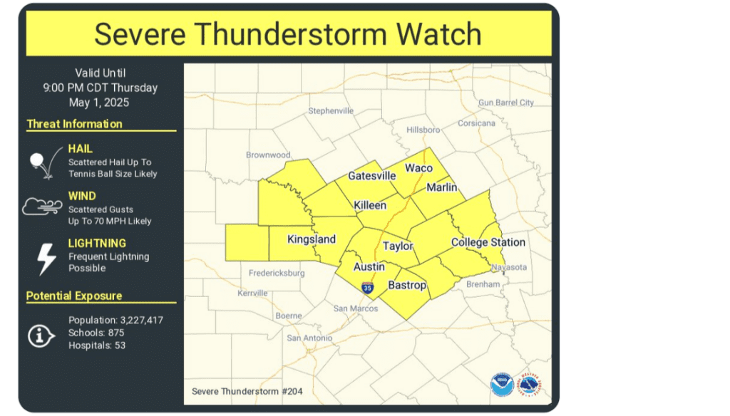
Remember, a Severe Thunderstorm Watch means conditions are favorable for severe thunderstorms in and close to the watch area. Persons in these areas should be on the lookout for threatening weather conditions and listen for later statements and possible warnings. Severe thunderstorms can and occasionally do produce tornadoes.
Developing storms this afternoon and evening are forecast to generally move from west to east.
The National Weather Service shows the window for severe storms across the watch area to generally be from 3 pm until 9 pm. Areas further to the south could see isolated storm in the window of 5 pm and 11 pm.
Rain from the isolated thunderstorms is forecast to average around a half inch, with isolated totals of 1-2 inches possible.
Bob
Social Media