

Showers Along a Cold Front Monday Night. Sunny and Slightly Cooler Tuesday through Friday
NOV. 2, 2026
The month of November has started off dry and unusually warm. Monday’s temperature is forecast to climb into the low and middle 80s across the region. However, Monday will likely to be the warmest day we’ll see for a while as a series of weak cold fronts move across the area over the next couple of weeks, keeping temperatures several degrees cooler.
Forecasters are closely monitoring the progress of our next cold front. As of early Monday afternoon, the front was just leaving eastern New Mexico and moving into the Texas Panhandle region. The cold front is predicted to make steady progress southeast across Texas Monday afternoon through Tuesday morning. Forecasts call for the front to reach the northern Hill Country around midnight Monday night, the Austin/Interstate 35 corridor between 3 am and 6 am Tuesday, and the middle Texas late Tuesday morning.
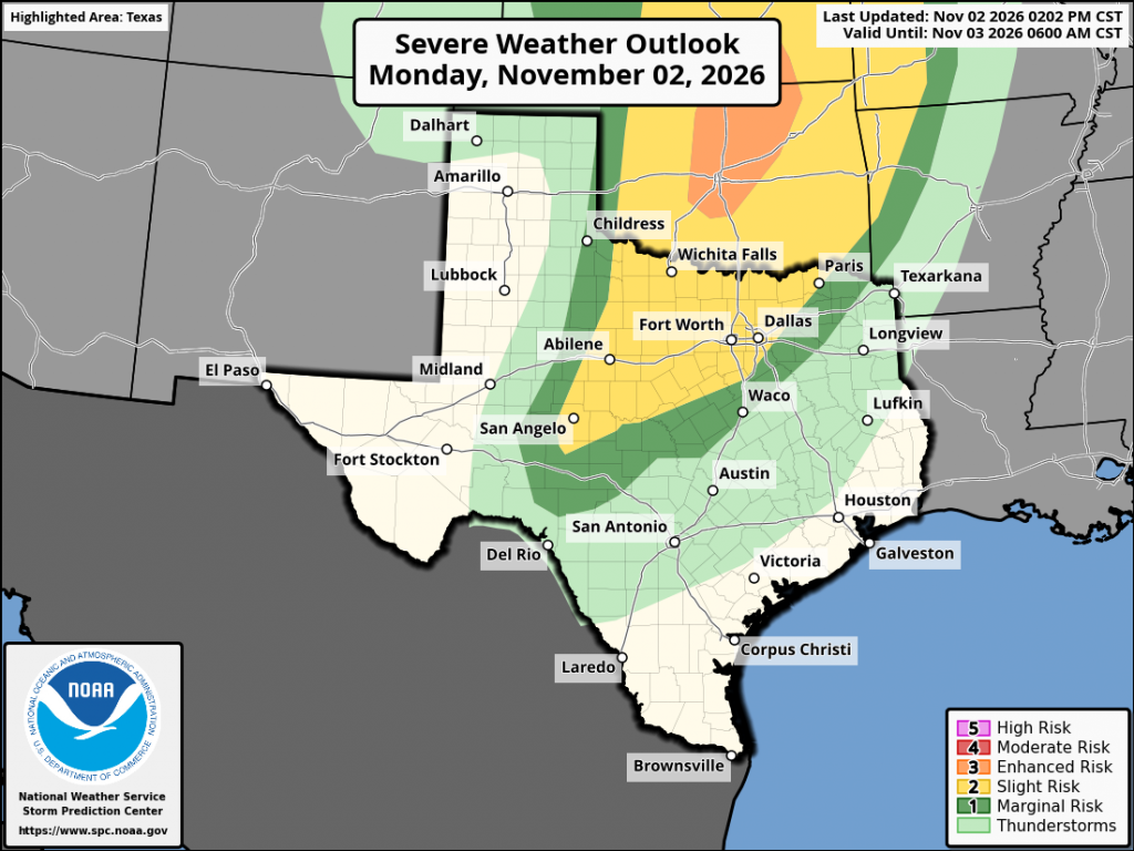
Atmospheric conditions appear favorable for a broken line of rain showers and scattered thunderstorms to develop along the cold front when it reaches northwest Texas. This area of rain and storms is predicted to spread southeast across the region with the front. Forecasts indicate the atmosphere will be structured in such a way that a few of the thunderstorms could become strong to severe. The most favorable area for severe storms is predicted to be across North Texas, extending southwest to near Brownwood and San Angelo. The Storm Prediction Center has placed this area under a Slight Risk, or a 2 out of 5 risk, for severe thunderstorms through Monday night. The area between Rocksprings, San Saba, and Waco have been placed under a Marginal, or 1 out of 5 risk, for severe thunderstorms Monday night. Across Central Texas and the middle Texas coast, the threat for severe storms appears to be quite low due to less favorable atmospheric conditions.
The Storm Prediction Center’s Severe Weather Outlook Valid through 6 am Tuesday:
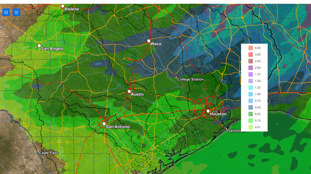
The line of showers and thunderstorms is forecast to spread southeast with the cold front, with the rain ending shortly behind the front. Rain amounts from the line of showers and thunderstorms are forecast to average between 0.25 and 0.5 inches across most of the region.
NWS Rainfall Forecast Valid through 6 pm Wednesday:
Clouds will clear from west to east behind the cold front Tuesday afternoon. Expect gusty northwesterly winds to around 20 mph. Wind speeds are expected to decrease Tuesday evening and Tuesday night. Tuesday’s temperatures is forecast to generally be in the low and mid-70s across the Hill Country and Central Texas. Towards the coast, high temperatures are forecast to be in the low 80s. Mostly sunny and dry weather will follow the cold front Wednesday through Friday.
Temperatures that are predicted to be more fall-like the second half of the week behind the cold front.
- High temperatures Wednesday through Friday are forecast to be in the mid and upper 70s
- Lows Wednesday through Friday are predicted to generally be in the low and mid-50s. A few Hill Country locations could see readings fall to the upper 40s
A change in the weather is forecast to take place this weekend when a small trough of low pressure pushes east out of northern Mexico. This system is expected to pull clouds and moisture back across the region beginning Friday night, continuing into the first half of Sunday. Forecast call for a 20-30 percent chance for occasional light rain showers through Sunday morning as the trough of low pressure slowly moves off to the east. Rain amounts through Sunday are predicted to average less than a quarter inch.
Temperatures look to trend a bit cooler this weekend. High temperatures both days are forecast to be in the mid and upper 60s. Lows will range from the mid and upper 40s across the Hill Country, to the low and mid-50s across the coastal plains.
The outlook for next week calls for dry weather throughout the week. A chance for rain may develop sometime next Friday or Saturday. Daily high temperatures are predicted to be in the 70s, with lows in the 50s.
Tropical Weather Outlook
Weather conditions are currently quiet across the Gulf, the Caribbean Sea, and the tropical Atlantic.
Across the southwestern Atlantic, NHC forecasters indicate an area of low pressure is likely to form in a couple of days along a weakening frontal boundary located a few hundred miles northeast of the Bahamas. This system could acquire some subtropical characteristics late this week while it drifts over the western Atlantic. The chances of subtropical development should end by the weekend when the system is expected to move eastward or northeastward into unfavorable environmental conditions.
NHC forecasters are giving this system a 30 percent chance for tropical development over the next seven days.
October Weather
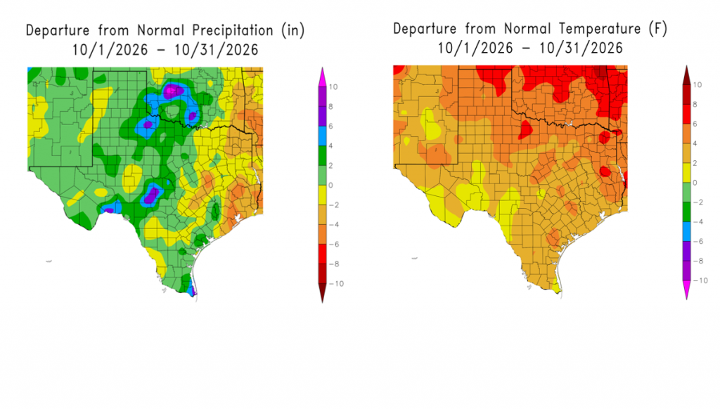
The month of October ended up being slightly wetter than normal across the Hill Country and slightly below normal for most areas east of Interstate 35. The wettest spot occurred across the Hill Country, between Junction and Mason.
The temperatures averaged warmer than normal at all locations across Texas. In Austin, October’s average temperature of 74.0 degrees tied for the 14th warmest October on record.
Have a good week!
Bob
Social Media