Showers and Storms Expected Saturday. Dry and Warm Weather Returns for Next Week
FEB. 13, 2026
The most active period of weather over the next week is expected to occur Saturday into Saturday evening when an approaching trough of low pressure causes the development of rain showers and scattered thunderstorms. There will be a low chance a couple of these storms could produce large hail and damaging winds.
Friday’s weather looks to remain quiet. Under a partly to mostly cloudy sky, the temperature should climb close to 80 degrees. Expect a southerly breeze at 10-15 mph, with occasional gusts up to 25 mph.
Friday morning’s satellite images showed a large trough of low pressure located over southern California and northwestern Mexico. This system is forecast to track eastward across northern Mexico Friday night moving across Texas Saturday and Saturday night. In advance of the approaching trough, atmospheric moisture will increase as southerly breezes persist off the Gulf. Weak atmospheric lift and increasing moisture levels are expected to cause the development of patchy light rain showers across the region beginning just after midnight Friday night. Lows Saturday morning will generally be in the low 60s.
For Saturday, expect the sky to remain cloudy throughout the day. Periods of light to moderate rain showers and scattered thunderstorms are forecast Saturday morning through Saturday afternoon as the atmosphere grows increasingly unstable. However, the most favorable period for moderate rain and a few strong to possibly severe storms is expected to occur late Saturday afternoon into Saturday evening when a Pacific cold front pushes east out of West Texas. High resolution forecasts call for a narrow line of storms to develop along the cold front from the Hill Country, southeastward to the coast. Some these storms, in addition to a few isolated thunderstorms Saturday afternoon, will have the potential to become strong to severe. Note a widespread severe weather threat is not anticipated due to limited atmospheric instability. The Storm Prediction Center has placed the entire region under a Marginal, or 1 out of 5 Risk, for severe thunderstorms Saturday through Saturday night.
Saturday’s atmospheric setup generally indicates the greatest severe weather threats will be large hail and damaging winds.
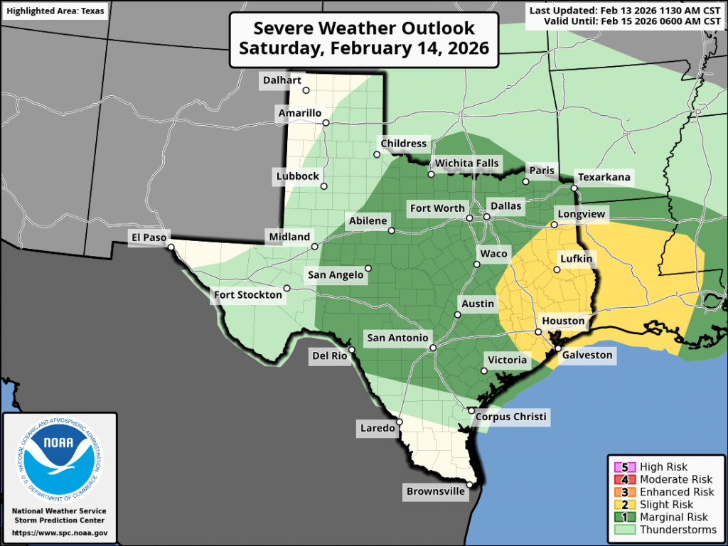
The rain should taper off from west to east Saturday evening an Saturday night as drier and more stable air spreads in behind the Pacific cold front
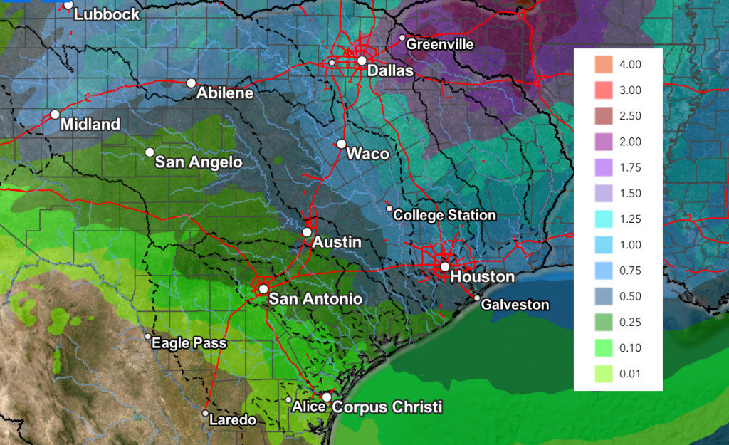
Rain amounts through Saturday evening are not expected to be very heavy across Central and South Texas, with the highest totals forecast across North Texas. For the Hill Country, Central Texas, and coastal regions, totals are forecast to generally range between 0.25 and 0.5 inches, with a few isolated to near 1 inch possible.
NWS Rainfall Forecast Valid through 6 am Sunday:
In the wake of Saturday’s rain and storms, a sunny and quiet weather pattern is shaping up Sunday and all of next week as the storm track remains well to the north of Texas. A broad ridge of high pressure covering Texas and the southeastern U.S. is expected to bring our region dry and unseasonably mild weather through late next week. High temperatures Sunday and early next week are forecast to be in the 70s, warming to the low 80s for the second half of next week. Low temperatures are predicted to generally be in the 50s.
Looking out into the week of February 23rd, forecasts call for continued warm temperatures, with some potential for rain throughout the week.
Fire Weather Concerns
Breezy weather and low relative humidity levels will be in place Sunday behind the cold front. Elevated to near-critical fire weather conditions are expected—mainly for areas along and west of Interstate 35.
Elevated fire weather conditions will persist across the entire region next week as dry air remains in place.
Have a great weekend!
Bob
Social Media