Showers and Thunderstorms Saturday. Temperatures Trend Cooler Saturday through Monday
April 17, 2026
Another period of wet and unsettled weather will be developing this weekend, with the wet pattern expected to last into early next week.
Friday’s weather is predicted to remain quiet ahead of weekend weather changes. Expect a partly cloudy sky with high temperatures in the mid and upper 80s. A strengthening pressure gradient across the state will cause breezy southerly winds, with speeds of 10-15 mph and occasional gusts to 30 mph Friday afternoon through Friday night.
Big changes in the weather are expected to take place Saturday when a strong cold front pushes south across the area. Forecasts call for the cold front to spread across the northern Hill Country just before sunrise, reaching the Austin area about mid-morning. The front should continue moving southeast Saturday afternoon and push off the middle Texas coast in the late afternoon. The front will bring noticeably cooler air and gusty northerly winds. Expect northerly winds at 10-15 mph with occasional gusts to 30 mph Saturday afternoon, continuing through Sunday.
For areas out ahead of the front, there will be a slight chance for a few showers and thunderstorms Saturday morning. An area of showers and isolated thunderstorms is forecast to develop right along the cold front as it presses to the southeast. However, a better chance for showers and scattered thunderstorms is predicted behind the cold front Saturday afternoon through Saturday night as a brief overrunning pattern sets up. With Saturday’s particular setup, the threat for any severe storms looks to be quite low. Periods of rain and occasional thunderstorms can be expected. The probability for rain will be near 50-60 percent. The chance for rain is expected to diminish late Saturday night as the overrunning pattern weakens.
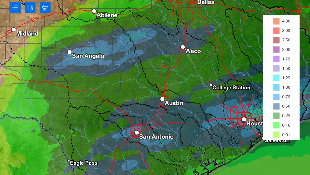
Rain amounts through Sunday morning are forecast to generally average between 0.25 and 0.75 inches, with some isolated totals to near 1 inch possible. Slightly higher totals are forecast for the coastal plains region.
NWS Rainfall Forecast Valid through 7 pm Sunday:
Partly cloudy and generally dry weather is predicted for most areas on Sunday. However, clouds and a few light showers are forecast for the western Hill Country and the Edwards Plateau regions.
Saturday’s cold front is expected to bring noticeably cooler air that should continue into next Tuesday.
- Saturday’s temperature is forecast to climb into the 70s ahead of the front, then fall through the 60s Saturday afternoon
- Lows Sunday morning will range from the upper 40s across the Hill Country, the mid-50s near the coast
- High temperatures Sunday are forecast to be in the low and mid-70s
- Lows Monday morning will be in the low and mid-50s, with upper 50s expected near the coast
- High temperatures Monday are forecast to be in the low and mid-60s
A chance for showers and scattered thunderstorms will return to the forecast beginning Monday morning and continue through Tuesday afternoon as several small waves of low pressure track across Texas out of northern Mexico. Periods of light to moderate rain can be expected, with the probability for rain around 40-50 percent. The threat for severe storms appears to be quite low.
Rain amounts Monday through Tuesday are forecast to generally average between 0.25 and 0.5 inches.
Wednesday through Friday, forecasts call for generally dry and warm weather across the region, although a few isolated showers cannot be ruled out. A better chance for rain looks to develop next weekend. The temperature will trend warmer beginning Wednesday, with high temperatures returning to the low and mid-80s.
Have a great weekend!
Bob
Social Media