Slowly Warming Temperatures Expected Before Another Arctic Front Arrives on Friday
JAN. 26, 2026
- The Extreme Cold Warning for the entire region has been extended until mid-morning Tuesday
- Temperatures forecast to fall into the teens Monday night into Tuesday morning
- Widespread hazardous travel impacts due to sub-freezing temperatures and ice and sleet on roads will continue through Tuesday
Clouds cleared Sunday night, allowing sunshine to return to our region. Despite the sun, widespread ice remains on the ground across the Hill Country and Central Texas. The ice was showing up on the following visible satellite image from 2 pm. The large area of white covering Central, West, and North Texas is all sleet, ice, and snow that has not melted or evaporated.
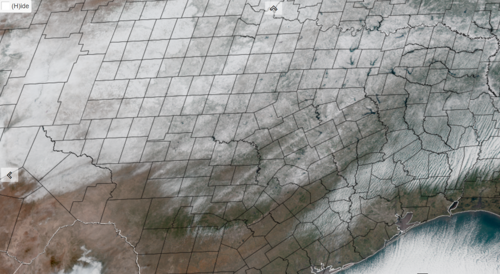
NOAA/Colorado State University/RAMMB 01-26-26 2 pm CST
Extremely cold temperatures are forecast to develop again Monday night under a clear sky. In fact, readings may be slightly colder than what was observed Monday morning.
- Lows Tuesday morning are predicted to reach the mid-teens across the Hill Country, the upper teens across Central Texas, and the upper teens to low 20s across the coastal plains. A few single digit temperatures look possible across parts of the Hill Country
Mostly sunny and warmer weather is forecast Tuesday through Thursday as light southerly breezes return off the Gulf. Readings should rise well above freezing at all locations on Tuesday. Very cold temperatures will continue Tuesday and Wednesday nights.
- High temperatures Tuesday are forecast to be in the mid and upper 40s
- High temperatures Wednesday are predicted to be in upper 40s to low 50s
- Highs Thursday are forecast to be near 58-60 degrees
- Low temperatures Wednesday morning will be in the low 20s across the Hill Country and Central Texas regions, with mid and upper 20s expected towards the coast
- Low temperatures Thursday morning will generally be in the mid and upper 20s, and be around 30 degrees towards the coast
- Lows Friday morning will include the upper 20s across the Hill Country, the mid-30s across Cetral Texas, and the upper 30s across the coastal region
Forecasts call for another arctic cold front to move across our area Thursday night into Friday morning, bringing another shot of very cold air that will last through the weekend. No precipitation is expected with the front when it moves across the Hill Country and Central Texas regions. However, the front may generate a few light rain showers across the coastal plains Thursday night. Rain amounts, if any, should total less than a quarter inch.
Sunny weather and chilly temperatures are predicted for Friday and the weekend.
- High temperatures Friday and Saturday are forecast to be in the mid and upper 40s
- Highs Sunday are forecast to be in the upper 40s to low 50s
- Lows Saturday and Sunday mornings are predicted to be near 20 degrees across the Hill Country, in the low and mid-20s across Central Texas, and in the mid and upper 20s across the coastal plains
Next week’s weather is shaping up to be milder as a ridge of high pressure spreads over Texas from the west. Expect high temperatures to be in the 60s, with lows in the 30s and 40s.
Bob
Social Media