Strongest Cold Front of Autumn Arriving Saturday Night
NOV. 7, 2025
Weather Highlights
- Sunny and unseasonably warm weather is forecast Friday afternoon and again on Saturday
- A strong cold front will move across the area Saturday night, bringing much colder weather for Sunday and Monday
- Expect northwesterly winds of 15-25 mph with gusts to near 40 mph Sunday
- The strong winds and very air are expected to cause critical fire weather conditions across the region Sunday
- Chilly temperatures are predicted Sunday and Monday nights
- A light freeze is forecast for much of the Hill Country Sunday night
- Milder temperatures will quickly return for Tuesday and the remainder of next week
Discussion
Our weather will be trending from unusually warm Friday and Saturday, to unusually cool Sunday and Monday as the strongest cold front so far this autumn moves across the region. Unfortunately, atmospheric conditions don’t appear favorable for the development of any rain along the front. The upcoming cold spell will be short-lived as mild temperatures make a quick return on Tuesday.
Sunny, breezy, and warm weather will be in place across the region Friday and Saturday. Friday morning, a weak Pacific cold front stretched across the Hill Country and was slowly pushing to the southeast. The front doesn’t contain much cool air and will mainly cause a wind shift. With little to no moisture in place, no clouds or rain are forecast. In advance of the front, expect southwesterly breezes with gusts to near 25 mph. For areas north of the boundary, expect a northerly breeze with speeds of 10-15 mph through late afternoon. The full sunshine and dry air will combine to produce unseasonably warm temperatures.
- Friday’s high temperature is forecast to be in the mid to upper 80s across the Hill Country, and near 88-90 degrees across Central Texas and the middle Texas coast
- Lows Saturday morning will include the low and mid-50s across Central Texas, with low and mid-60s across the coastal plains
The front is forecast to reach the Austin/Interstate 35 corridor late Friday afternoon and stall near the Interstate 10 corridor around midnight. Sunny and warm weather will follow Saturday with high temperatures generally in the mid to upper 80s
A strong cold front is predicted to push south through the region Saturday night, resulting in a pronounced cooldown and windy conditions on Sunday. While the brunt of the coldest air with the front is aimed at the southeastern U.S., cold air is also expected to spill into Texas, bringing some of the coldest readings we’ve seen so far this autumn. The front is forecast to stay rain-free when it moves across our region. Sunny weather in the wake of the front on Sunday.
Windy conditions look to develop behind the cold front late Saturday night and remain strong Sunday into Sunday evening. Expect northwesterly winds at 15-25 along with occasional gusts to 40 mph. Lighter winds are forecast Sunday night into Monday. Do note; the strong winds and dry air will cause critical fire weather conditions across the region Sunday. (See the fire weather section below)
Some of the coldest temperatures so far this autumn are forecast to occur Sunday through Monday. A light freeze will be possible across most of the Hill Country and across some of the low valleys across Central Texas Sunday night. Tender vegetation across these two areas should be given extra protection.
- Low temperatures Monday morning are forecast to be in the low 30s across the Hill Country, in the mid and upper 30s across Central Texas, and the low 40s across the coastal plains
- Low temperatures Tuesday morning are forecast to be in the mid and upper 30s across the entire region
- High temperatures Sunday are predicted to be in the low and mid-60s across the Hill Country and Central Texas regions, and near 70 degrees towards the coast
- High temperatures Monday are predicted to be in the upper 50s to low 60s
A warming trend will begin Tuesday and continue through late week as the cold dome of high pressure shifts to the east, bringing a return of southeasterly breezes. Sunny and dry weather is forecast throughout the week as our region remains under a stagnant of high pressure.
- High temperatures Veterans Day are forecast to generally be in the low 70s. Highs in the low and mid-80s are forecast Wednesday through Friday
- Low temperatures Wednesday through Friday mornings will range from the low 50s across the Hill Country, to the low 60s across the coastal plains
Extended Outlook
The outlook for next weekend and the week of November 17th calls for little change in the weather pattern as our region remains under a stagnant ridge of high pressure in the upper atmosphere. No rain is forecast. High temperatures are forecast to be in the upper 70s to low 80s, with lows mostly in the 50s.
Fire Weather Outlook
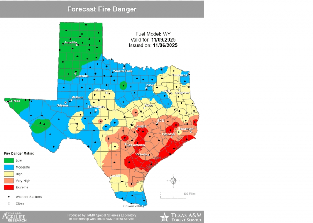
The combination of strong winds, very low relative humidity readings and extremely dry vegetation is expected to cause critical fire weather conditions across the entire region on Sunday. As a result, the National Weather Service has posted a Fire Weather Watch for most of the region from Sunday morning through Sunday evening. Counties highlighted below are included in the Fire Weather Watch.
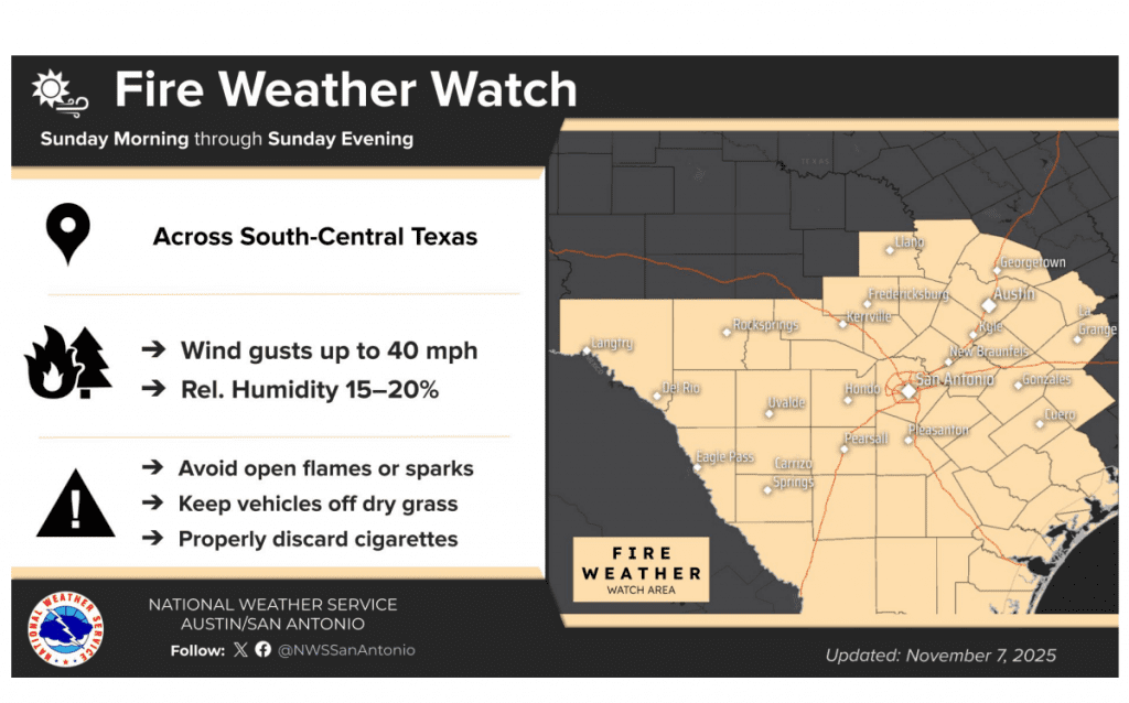
A Fire Weather Watch means that critical fire weather conditions are forecast to occur. Listen for later forecasts and possible Red Flag Warnings.
There may be enough return flow with continued dry air for some elevated to near critical fire weather concerns for portions of the region next Tuesday and Wednesday.
Tropical Weather Outlook
Weather conditions are quiet across the Atlantic basin and tropical cyclone development is not forecast over the next seven days
Have a great weekend!
Bob
Social Media