Temperatures to Trend Back Warmer this Week. The Dry Weather Pattern will Continue
DEC. 29, 2025
Sunday’s strong cold front brought an abrupt end to our recent stretch of unseasonably warm temperatures. Readings tumbled some 20-30 degrees Sunday night as cold air spread south behind the front. Monday’s weather maps showed a large dome of Canadian high pressure over the central Plains that was directing cold air south into Texas. A strong pressure gradient associated with the high will cause breezy conditions through late Monday afternoon. Expect northerly winds with speeds of 10-20 mph and occasional gusts up to 30 mph. Wind speeds are forecast to decrease to between 10 and 15 mph Monday night.
A small wave of low pressure pushing east out of West Texas is helping to produce a widespread area of clouds across the state. The low may cause a few sprinkles of light rain across the area throughout the afternoon, but little if any measurable rain is expected. The clouds will persist into Monday evening, then slowly clear from west to east Monday night as the wave of low pressure exits to the east.
- Monday’s cloud cover will help keep the temperature chilly. High temperatures will include the low 40s across the Hill Country, the mid and upper 40s across Central Texas, and the low 50s across the coastal plains
- Low temperatures Tuesday morning are forecast to be in the low 30s across the Hill Country, the mid and upper 30s across Central Texas, and the upper 30s towards the coast
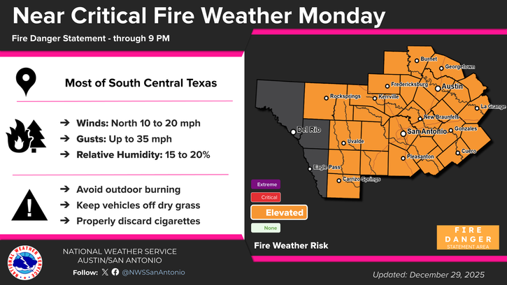
Monday’s combination of gusty winds, low relative humidity values, and dry vegetation is expected to cause near-critical fire weather conditions across the region. The National Weather Service has posted a Fire Danger Statement for the Hill Country and Central Texas regions through 9 pm Monday night.
Sunny and dry weather will be in place Tuesday through the upcoming weekend as a mid-level ridge of high pressure spreads over Texas out of the southwestern U.S. Cold air will hold in place Tuesday and Tuesday night followed by a warming trend Wednesday through late week as southerly breezes return off the Gulf.
A light freeze is forecast across the Hill Country and parts of Central Texas Tuesday night into Wednesday morning.
- Lows Wednesday morning are forecast to be in the low 30s across the Hill Country, with the low and mid-30s across Central Texas and the middle Texas coast
- Lows Thursday morning will generally be in the upper 30s to low 40s
- Lows Friday morning will be in the mid-50s to 60 degrees
- High temperatures Wednesday are forecast to be in the mid and upper 60s
- Highs New Years Day are predicted to be in the low 70s
- High temperatures Friday are forecast to be in the low and mid-80s
Temperatures New Year’s Eve are predicted to generally be in the upper 40s to low 50s.
A weak Pacific cold front is forecast to move across the region early Saturday, causing just a slight drop in the temperature. Unfortunately, no rain is expected with the front. Sunny weather will continue, with high temperatures both days in the mid and upper 70s. Low temperatures will be in the upper 40s to mid-50s.
Next Week
Mostly sunny and dry weather is forecast to continue through late next week. Forecasts call for cold fronts to move across the region late Monday with a second cold front arriving sometime around next Thursday. High temperatures next week are forecast to be in the mid-60s to mid-70s. Low temperatures are predicted to be mostly in the 40s.
There are no indications for arctic air reaching Texas through the middle of January.
Wishing everyone a safe and Happy New Year!
Bob
Social Media