Temperatures to Turn Unusually Mild. Still No Significant Rain on the Horizon
DEC. 15, 2025
Some of the coldest temperatures so far this fall/winter occurred early Monday across Central Texas and the middle Texas coast. The combination of a clear sky and light winds allowed readings to fall below freezing across the eastern Hill Country and across all Central Texas. Lows were generally in the upper 20s to low 30s. According to LCRA’s Hydromet, freezing temperatures were observed all the way south to around Interstate 10. Interestingly, light southerly winds and clouds helped to keep the temperature just above freezing across the western half of the Hill Country. In Austin, Camp-Mabry recorded its first freeze of the season, with a low of 32 degrees. Meanwhile, Austin-Bergstrom Airport recorded a low of 29 degrees.
Monday morning’s chilly readings look to be the coldest we’ll see all week. The dome of Canadian high pressure which brought the cold air for Sunday and Sunday night has already moved east to the Mississippi Valley region, causing our surface winds to turn out of the southeast and south. As a result, milder temperatures can be expected Monday night, continuing through Thursday. No additional freezes are forecast.
Sunny conditions will be in place Monday afternoon, but low clouds are forecast to increase and spread over the region Monday evening and Monday night. Widespread clouds are predicted for Tuesday and Tuesday night in advance of a small trough of low pressure that will be tracking to the east out of northern Mexico. With moisture increasing ahead of the trough, a few light rain showers will be possible for areas along and east of Interstate 35 beginning Tuesday night, continuing through Wednesday morning. The probability for rain will only be near 20-30 percent. Totals, if any, are predicted to only average around a tenth of an inch, or less. A partly to mostly cloudy sky will persist Wednesday afternoon and Wednesday night.
- High temperatures Monday afternoon will generally be in the mid-50s
- Lows Tuesday morning are forecast to be mostly in the low 40s
- High temperatures Tuesday are predicted to be in the low and mid-60s
- Lows Wednesday morning will be in the low and mid-50s
- High temperatures Wednesday are forecast to be in the low and mid-70s
Another Canadian cold front is forecast to push south across the region Thursday afternoon and Thursday night. Note the air behind this next front isn’t expected to be quite as cold as what we saw on Sunday. Nevertheless, slightly cooler temperatures are forecast Thursday night and Friday. The air will be too dry to support any rain along the front. A mostly sunny sky is forecast Thursday and Friday.
- High temperatures Thursday will be in the low 70s north, with upper 70 to 80 degrees at all other locations
- Low temperatures Friday morning will include the upper 30s to low 40s across the Hill Country, the low 40s across Central Texas, and the mid to upper 40s across the coastal plains
- High temperatures Friday will generally be in the upper 60s
- Lows Saturday morning are forecast to be in the upper 40s to low 50s
The outlook for the upcoming weekend calls for mostly sunny, dry, and unseasonably mild weather as Texas comes under the influence of a broad area of high pressure stretching across the southern U.S. Unusually mild temperatures are forecast both days, with highs in the mid and upper 70s. Lows will range from the low 40s across the Hill Country, to the upper 50s and low 60s across the coastal plains
Next Week
Mostly sunny, dry, and unseasonably mild is forecast next week as an unusually strong ridge of high pressure develops over Texas and the south-central U.S. Daily high temperatures (including Christmas Day) are predicted to be in the 70s to near 80 degrees. Low temperatures are forecast to be in the 50s to low 60s.
The ridge is forecast to weaken late next week but a mild flow Pacific flow is expected to continue, keeping temperatures in the unusually mild range through the end of the month.
Unfortunately, no significant rain is predicted through the end of the month.
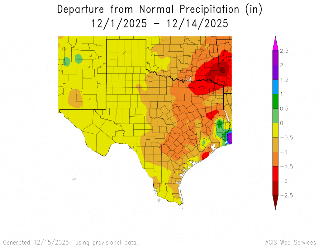
Tracking a Dry December
The first half of December has been quite dry across the Hill Country and Central Texas regions, with totals averaging less than a quarter inch. Across the coastal region, totals have been close to an inch for areas south of U.S. 59. With no significant rain in the forecast for the next couple of weeks, drought conditions will likely deteriorate as we close out the year.
Have a great week!
Bob
Social Media