

The Dog Days of Summer will Likely Continue for a While Longer
AUG. 10, 2026
No significant change in the weather is expected this week or this weekend as a persistent heat dome remains over the region.
Monday afternoon and evening will see some active weather across the coastal plains region and the southern counties of Central Texas as an enhanced area of tropical moisture associated with a weak tropical wave spreads inland from the Gulf.
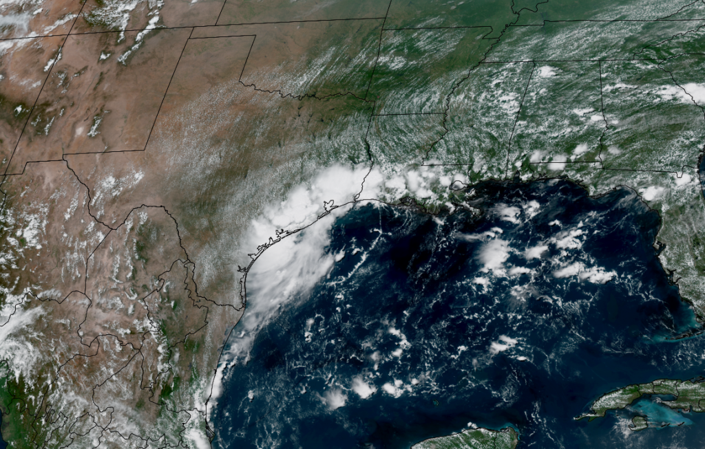
NOAA/Colorado State University/CIRA 08/10/2026 1:20 pm CDT
The tropical wave brought numerous showers and thunderstorms to the middle and upper Texas coast Monday morning into Monday afternoon. As of 2 pm, LCRA’s Hydromet showed spotty totals of 0.5 to 1 inch falling across parts of Matagorda and Wharton Counties. However, a gauge located in northwestern Brazoria County had recorded nearly 2 inches of rain. Additional showers and thunderstorms are forecast across the coastal plains region, extending inland to Fayette, Gonzales, Austin, and Washington Counties through Monday evening. Some locally heavy downpours will be possible. The probability for rain will be near 50 percent.
Further inland, there will be a 20 percent chance for scattered rain showers and isolated thunderstorms along and just east of the Interstate 35 corridor late Monday afternoon through Monday evening. Spotty totals to around a half inch will be possible. Little to no rain is forecast across the Hill Country.
All the rain and thunderstorm activity is forecast to diminish around sunset as temperatures begin to lower. The weak tropical wave is forecast to fall apart overnight.
- Monday’s high temperatures will include the mid and upper 90s across the Hill Country and Central Texas regions, with upper 80s across the coastal plains
A sunny, hot, and rain-free weather pattern is forecast Tuesday through the upcoming weekend as the center of the heat dome relocates from the Four Corners region to the northern Gulf. This change of location is expected to have little to no impact on our region’s weather.
Do note: Wednesday and Thursday are shaping up to be the hottest days of the week as some dry and hot air in the middle atmosphere gets pulled into Texas out of Mexico. High temperatures both days are forecast to be near 98-100 degrees across the Hill Country, near 100-102 degrees across the Austin/Central Texas area, and into the mid and upper 90s across the coastal region.
- Late week and through the weekend, high temperatures are forecast to be in the upper 90s across the Hill Country, in the upper 90s to 100 degrees across Central Texas, and in the mid-90s across the coastal plains.
The outlook for next week calls for few changes as the heat dome continues to cover Texas and the south-central U.S. No rain is expected, with little change in the daily high temperatures.
One growing concern across the Hill Country and Central Texas regions will be the potential for new fire starts from mid-week onward, owing to a decrease in afternoon relative humidity levels and an uptick in gusty winds. These increased fire weather parameters are mapping on a region with fuels that are steadily curing due to the protracted absence of widespread rainfall. Elevated fire concerns are likely to be a growing problem through the remainder of the month and on into September, given the likelihood of continued rainfall deficits and very hot temperatures.
Tropical Weather Outlook
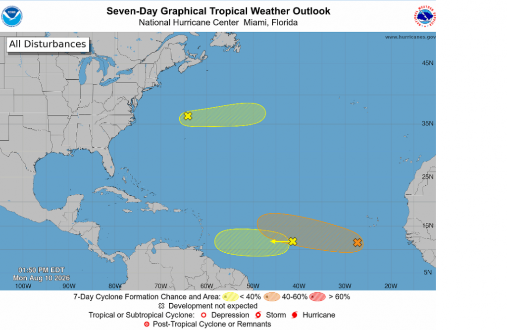
Conditions across the tropical Atlantic began to wake up over the past couple of days. The National Hurricane Center is monitoring three different areas of possible tropical development. None of these pose a threat to the Gulf region at this time.
- Across the Eastern and Central Tropical Atlantic, NHC forecasters are monitoring an area of low pressure located a few hundred miles southwest of the Cabo Verde Islands that is producing a large area of showers and thunderstorms. As this low moves slowly westward over the next couple of days, a tropical wave emerging off the coast of west Africa is expected to interact with the system. Environmental conditions are forecast to be more conducive for development by mid-week, and a tropical depression could form during the latter half of this week while the system moves westward to west-northwestward across the central tropical Atlantic. Tropical cyclone development over the next seven days is forecast to be near 60 percent.
- Across the central Tropical Atlantic, NHC forecasters are tracking an area of disorganized showers and thunderstorms associated with a tropical wave located about midway between the coast of west Africa and the Lesser Antilles. Some gradual development of this system will be possible through mid-week while the system moves quickly westward across the central tropical Atlantic. Environmental conditions are expected to become less favorable for development later this week when the system approaches the Lesser Antilles. Tropical cyclone development over the next seven days is forecast to only be near 10 percent.
- Across the western subtropical Atlantic, forecasters are following a trough of low pressure located a few hundred miles north of Bermuda that is producing disorganized shower and thunderstorm activity. Some development of this system will be possible during the next couple of days as the system moves quickly eastward, well to the north of Bermuda, across the western and central subtropical Atlantic. The system is forecast to reach cooler waters late this week, ending its chances of formation after Wednesday. Tropical cyclone development over the next seven days is forecast to only be near 10 percent.
Elsewhere, tropical cyclone development is not forecast over the next seven days.
Perseid Meteor Shower this Week
A reminder…One of the best meteor showers of the entire year, the Perseids, will be at peak this Wednesday and Thursday morning. The best time to watch the Perseid meteor shower will be from midnight through dawn on August 12th and 13th. The sky will be moon-free on both nights. And since the Perseids are often bright, you might see between 50 and 100 meteors per hour! Remember, even one bright meteor can make your night!
The August Perseid meteor shower is rich and steady, from early August through the peak. The meteors are colorful and many of them are bright. And they frequently leave persistent trains. All of these factors make the Perseid shower perhaps the most beloved meteor shower for the Northern Hemisphere.
Have a great week!
Bob
Social Media