

The Heat Will Continue into Next Week. Some Slight Changes on the Horizon
SEPT. 18, 2026
The unusually hot, August-like temperatures we’ve been experiencing throughout September look to continue this weekend and the first half of next week. But there are signs the very hot weather pattern will begin to breakdown late next week as the heat dome over Texas weakens and a weak cold front brings in some slightly cooler/less hot air. High temperatures late next week into next weekend are predicted to fall to the low and mid-90s! While certainly not sweater weather, I do believe we’ll see a noticeable change in the level of heat. These more moderate-level temperatures are forecast to persist into early October. The end of the triple-digit temperatures is on the horizon! Unfortunately, no significant rain is predicted anytime soon.
Friday’s weather maps showed a broad and intense heat dome stretching from the Ohio Valley to northern Mexico. The center of the heat dome was situated over northeastern Texas and southeastern Oklahoma. A weak wave of low pressure tracking west along the southern boundary of the heat dome over South Texas was causing scattered showers over the area between Victoria and San Antonio Friday morning. This area of showers is forecast to spread northwest into the southern Hill Country Friday afternoon, with rain amounts averaging less than a quarter inch. Elsewhere, no rain is forecast Friday afternoon as drier and more stable air spreads in from the east. Expect a mostly sunny sky.
Mostly sunny, dry, and hot weather will be in place this weekend as the center of the heat dome shifts southwest over Central Texas. Relative humidity levels will be a bit lower thanks to the drier air spreading in from the Gulf.
- High temperatures Friday through Sunday are forecast to be in the mid and upper 90s across the Hill Country, in the upper 90s to 100 degrees across Central Texas, and in the mid-90s across the coastal plains
There will be a slight chance for scattered rain showers and isolated thunderstorms across the region Monday and Tuesday as the heat dome weakens over Texas. At the same time, a couple of troughs of low pressure are forecast to track east across the southern Plains states, helping to push a weak cold front into North Texas. With a weaker ridge in place, a stalled cold front up to our north and moisture spreading inland from the Gulf, expect the development of scattered rain showers and isolated thunderstorms across the region. The probability for rain both days will only be 20 percent. For areas that do happen to see rain, totals should average around a quarter inch.
Mostly sunny and dry weather is predicted Wednesday through Friday as the heat dome perks up a bit to cause generally dry weather.
- High temperatures Monday through Wednesday are forecast to remain mostly in the mid and upper 90s
Temperatures are expected to trend down a bit beginning next Thursday. Forecasts call for a deep trough of low pressure to develop across the northeastern U.S. and Great Lakes region late next week, pushing a cold front south across the Plains and through Texas. A few scattered showers may accompany the cold front on Thursday, but no significant rain is predicted. Dry and sunny weather is forecast late next week into next weekend.
- High temperatures next Thursday through Sunday are forecast to be in the low 90s across the Hill Country and in the low to mid-90s across Central Texas and the coastal plains
- Low temperatures next Friday through Sunday mornings are predicted to be near 70-72 degrees
Looking out into the week of September 28th, forecast solutions call for the “less hot” temperatures to continue as the heat dome weakens significantly. Daily high temperatures are forecast to generally be in the low 90s. Low temperatures are predicted to be near 68-70 degrees. No rain is forecast.
Tropical Weather Outlook
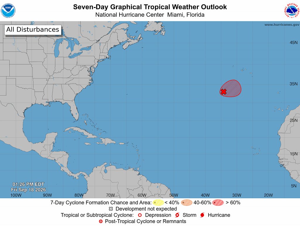
Weather conditions remain quiet across the Gulf, the Caribbean Sea, and the tropical Atlantic. Tropical cyclone development is not expected over the next seven days.
Out over the eastern subtropical Atlantic, showers and thunderstorms appear to be getting better organized in association with an area of low pressure located several hundred miles southwest of the Azores. However, just a small increase in organization is likely to result in the formation of a tropical depression as soon as Friday evening. The system is expected to move slowly over the next couple of days remaining southwest of the Azores, followed by a turn to the southwest by early next week, when environmental conditions are forecast to become less favorable for additional development.
NHC forecasters are giving this system a 70 percent chance for tropical development over the next seven days.
Updated Weather Outlook for October
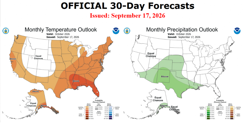
On Thursday, NOAA’s Climate Prediction Center issued their monthly outlook for October. For Texas, the outlook leaned toward above normal rainfall and temperatures across all of Texas. NOAA forecasters noted good agreement among the various forecast solutions calling for rainfall to increase in coverage beginning sometime in the middle of latter part of the month. While temperatures are predicted to average above normal, a continuation of September’s very hot weather is not forecast.
Have a great weekend!
Bob
Social Media