The Hot and Dry Pattern Appears to be Settling in for a Long Stay
June 26, 2026
Our region remains in the grips of a hot and dry weather pattern that is showing no signs of changing anytime soon.
Friday’s weather maps showed a broad ridge of high pressure, or heat dome, covering the entire southern U.S. The ridge is currently centered over southern Mexico. This weekend into early next week, the center of the ridge is forecast to quickly shift east and set up over the Mississippi and Ohio Valleys. The heat dome is expected to bring extreme heat to parts of eastern Texas and the eastern U.S. next week. For Central and South Texas, it appears there will be little significant change in our weather or the temperatures.
Friday afternoon through late next week, the persistent heat dome looks to cause more sunny, hot, and rain-free weather. A tightened pressure gradient through the period will support breezy to occasionally windy conditions, with the strongest gusts expected during the afternoon and early evening hours. Expect southerly winds at 10-15 mph, with occasional gusts up to 25/30 mph. While the wind may provide some perceived relief from the heat at times, it will also help to keep the lower atmosphere mixed, maintain Gulf moisture, and limit overnight cooling. The mixed atmosphere will help to keep peak heat index readings generally in the range of 100-105 degrees.
- High temperatures Friday through Sunday are forecast to generally be in the mid-90s across the Hill Country and Central Texas regions, and in the low 90s across the coastal plains
- High temperatures Monday through Friday are predicted to climb to the upper 90s across the Hill Country and Central Texas region, and be in the low to mid-90s across the coastal plains
A few spotty rain showers and isolated thunderstorms will be possible across the middle Texas coast next Wednesday through Friday as moisture increases off the Gulf. The probability for rain each day will only be near 20 percent, and rain amounts should average less than a quarter inch.
The outlook for the Fourth of July weekend, calls for little change.
Looking out into the week of July 6th, forecasts call for more sunny, hot, and rain-free weather as the center of the heat dome returns to a position over New Mexico. Daily high temperatures are predicted to remain in the upper 90s, with low and mid-90s predicted across the coastal region.
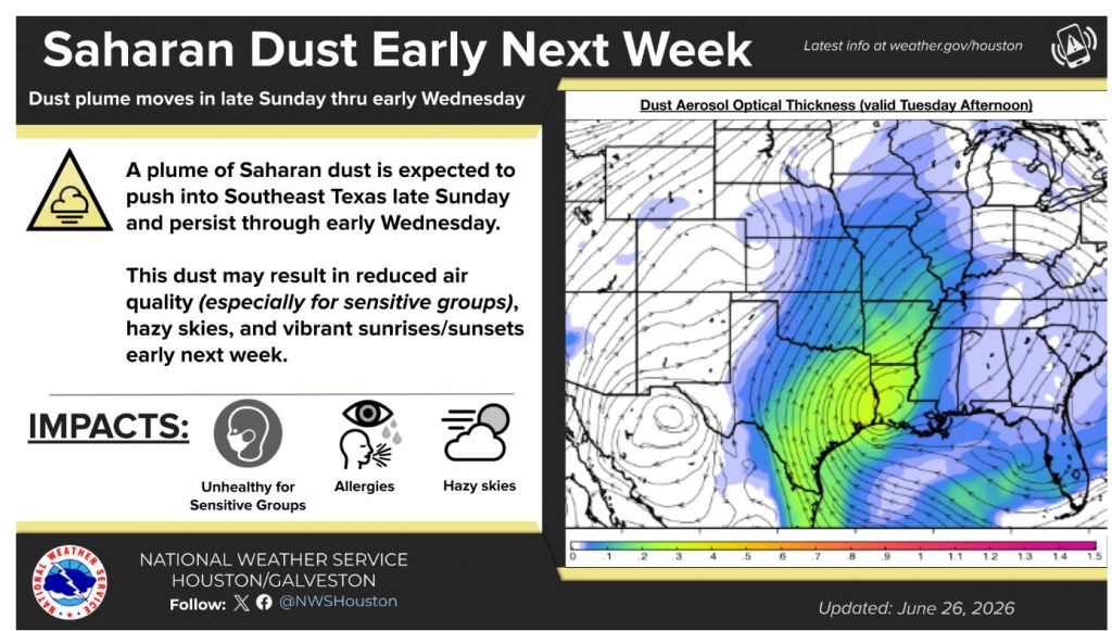
A Plume of Saharan Dust Headed for Texas
Forecasters are currently following a large plume of Saharan dust that is currently located over the Caribbean Sea. It can be seen in this visible satellite image as a brownish area stretching from just east of Belize, to Lesser Antilles.
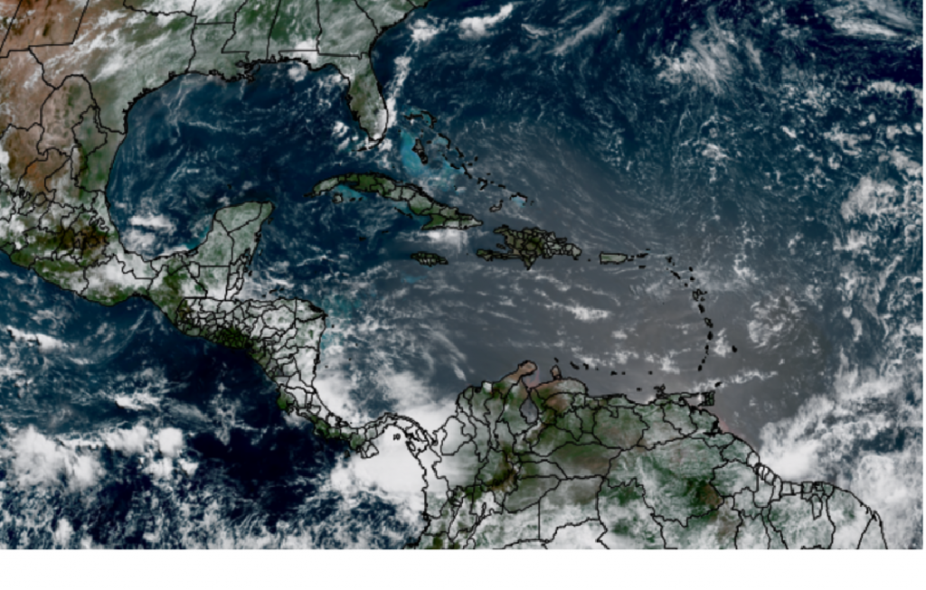
NOAA/Colorado State University/CIRA 06/26/2006 10:10 am CDT
Forecasts call for the plume of Saharan dust to turn northwest and spread north across the eastern two-thirds of Texas Monday through late Tuesday. This dust may result in reduced air quality (especially for sensitive groups), hazy skies, and vibrant sunrises/sunsets early next week.
Tropical Weather Outlook
Weather conditions remain quiet across the tropical Atlantic and tropical cyclone development is not forecast over the next seven days.
June’s Full Strawberry Moon
The June 2026 full moon, known as the Strawberry Moon, will reach peak illumination on Monday, June 29th, at 6:58 pm CDT. Look for the moon to appear quite bright and nearly full this weekend.
Have a good weekend! Remember to stay cool and hydrated!
Bob
Social Media