

The Unseasonably Hot Pattern Will Continue through the Upcoming Weekend
SEPT. 22, 2026
…Forecasts are finally pointing to a weakening of the unseasonably hot weather pattern next week…
Unfortunately, no significant change in the temperature is forecast this week. There will be a slight chance for scattered rain showers and thunderstorms across the region Tuesday and Wednesday afternoons. Tuesday’s weather maps showed a weak cold front/wind shift line stretching across North Texas, from around Shreveport, to Stephenville, to Big Spring. The front is forecast to remain nearly stationary over roughly the same area through Wednesday, providing a focus for the development of scattered showers across West Texas and the northern Hill Country. Rain activity developing along and just south of the front is predicted to move slowly to the southeast. Across Central Texas and the middle Texas coast, persistent tropical moisture and weak atmospheric instability will help cause the development a few scattered rain showers and thunderstorms both afternoons. The probability for rain Tuesday will be near 20-30 percent, while the chance for rain Wednesday will be 20 percent. Rain amounts both days should average less than a quarter inch, with isolated totals of 1-2 inches possible.
- High temperatures Tuesday through Thursday are predicted to be in the mid and upper 90s across the Hill Country and coastal regions, and near 98-100 degrees across Central Texas
Mostly sunny, dry, and hot weather is forecast across the region Thursday through Sunday. The cold front situated across North Texas is predicted to push south across the area late Thursday, bringing somewhat drier air to the area for Friday and Saturday. The humid air should return back to the north on Sunday.
- High temperatures Friday through Sunday are forecast to be mid-90s across the Hill Country and coastal regions, and in the upper 90s across Central Texas.
Changes to the persistently hot and dry summer pattern are forecast to take place across Texas early next week as the heat dome finally begins to weaken. At the same time, a trough of low pressure is predicted to push inland along the West Coast and move toward the southern Plains states. The trough will help push a Pacific cold front across Texas next Tuesday into Wednesday, bringing slightly cooler air to the region for the second half of next week. High temperatures are forecast to fall from the mid-90s Monday and Tuesday, to the upper 80s to 90 degrees Wednesday through Friday. Low temperatures should fall to around 68-70 degrees. Showers and scattered thunderstorms are forecast ahead of and along the cold front Tuesday into Wednesday, with dry weather developing behind the front on Thursday.
Tropical Weather Outlook
Weather conditions remain quiet across the Gulf and the Caribbean Sea and tropical cyclone development is not expected across this area over the next seven days.
- Tropical Storm Fay, located about 645 miles southwest of the Azores, has weakened to a tropical depression, with top winds of 35 mph. Fay appears to be moving into an unfavorable environment and is forecast to weaken into a post-tropical remnant low Tuesday night or Wednesday.
- Out across the far eastern Atlantic, a tropical wave is forecast to move off the coast of western Africa on Wednesday. Although upper-level winds are not very conducive, some slow development of this system will be possible while it moves generally northwestward across the far eastern Atlantic. National Hurricane Center forecasters are giving this system a 30 percent chance for tropical development over the next seven days.
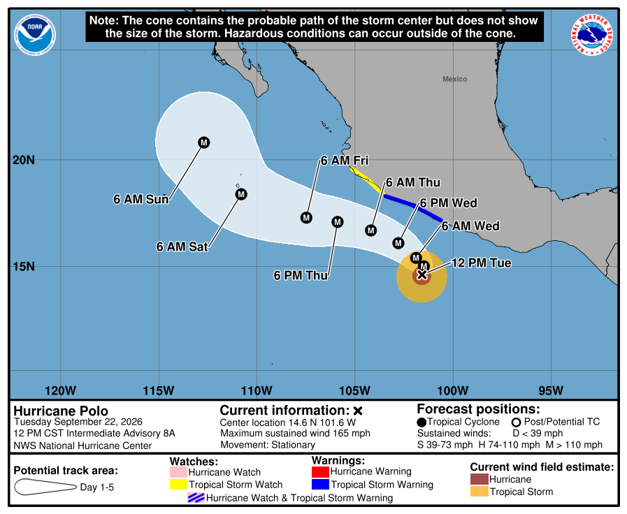
- Over in the eastern tropical Pacific, extremely dangerous category 5 Hurricane Polo develop early Tuesday morning off the west coast of Mexico. As of 1 pm CST, Polo was centered about 350 miles south-southeast of Manzanillo, Mexico. Polo was nearly stationary, but a generally west-northwestward motion is expected over the next couple of days. On the forecast track, the core of Polo is expected to be near the coast of southwestern Mexico through the middle of this week, although the storm is forecast to remain offshore. Maximum sustained winds are near 165 mph with higher gusts. Polo is a category 5 hurricane on the Saffir-Simpson Hurricane Wind Scale. Some additional strengthening is likely through tonight, with fluctuations in strength possible Wednesday and Wednesday night. A NOAA Hurricane Hunter aircraft was enroute to investigate Polo Tuesday afternoon.
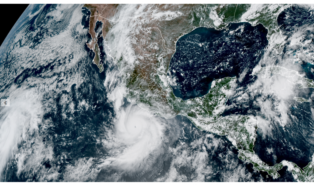
NOAA/Colorado State University/CIRA 09/22/2026 3:10 pm CDT
The Beginning of Fall
The autumnal equinox happens at 7:05 pm CDT Tuesday, Sept. 22. The fall equinox marks the beginning of autumn in the Northern Hemisphere. On this day, most areas of the globe will see roughly 12 hours of daylight and darkness.
Have a great week!
Bob
Social Media