The Weather Pattern Will Trending Wet and Unsettled Late Week and through the Weekend
March 2, 2026
After several weeks with little to no precipitation, the weather pattern will be changing this week. Several rounds of rain showers and thunderstorms are forecast to begin Friday and persist through the upcoming weekend. While this week’s rains likely won’t be a drought buster, they should be heavy enough to bring drought improvement to most of the region.
Little change in the weather is forecast Monday afternoon through Tuesday night as our region remains under the influence of a stable ridge of high pressure and a moderate wind flow off the Gulf. Widespread low clouds are forecast to develop Monday evening and spread over the region Monday night through mid-morning Tuesday. These clouds will unfortunately result in poor to non-existent viewing conditions for the lunar eclipse Tuesday morning. In addition, some patchy fog will be possible for areas south of Interstate 10. The clouds and fog should break late morning Tuesday, with the sky becoming mostly sunny Tuesday afternoon.
- High temperatures Monday and Tuesday are forecast to be in the low and mid-80s
- Lows Tuesday morning are predicted to be in the upper 50s to low 60s
- Lows Wednesday morning are forecast to be in the low and mid-60s
Wednesday’s weather will feature a low chance for scattered rain showers through the morning hours, followed by a 50-60 percent chance for rain showers and scattered thunderstorms Wednesday afternoon through Wednesday night across the Hill Country and Central Texas regions. A trough of low pressure tracking east out of New Mexico will help pull considerable moisture north from the Gulf while causing the atmosphere over our region to become somewhat unstable. The probability for strong and severe storms will be low. The Storm Prediction Center has placed the northern half of the Hill Country and Central Texas under a Marginal, or a 1 out of 5 risk for severe thunderstorms Wednesday through Wednesday night. Should any severe storms develop, large hail and damaging winds will be the primary severe weather threats. Rain amounts through daybreak Thursday are forecast to generally average between a quarter and a half inch.
Little to no rain is forecast across the coastal plains region on Wednesday.
Thursday’s weather will include a slight chance for lingering rain showers across the Hill Country and Central Texas regions through the morning hours as the trough of low pressure slowly pushes off to the east. Partly cloudy and dry weather will follow Thursday afternoon and evening. Expect a high temperature in the mid and upper 80s.
A larger and stronger trough of low pressure is forecast to push inland along the West Coast late week. The trough is predicted to slowly sink south to a position across northwestern Mexico and southern California this weekend and early next week, then finally lift off to the northeast the middle of next week. Abundant moisture flowing north from the Gulf in combination with weak waves of low pressure tracking east out of the Desert Southwest are expected to create favorable atmospheric conditions for the development of showers and thunderstorms across much of Texas. Multiple rounds of rain showers and thunderstorms are forecast beginning Friday afternoon, continuing through the weekend. The probability for rain each day will be near 50-60 percent.
Forecast solutions are showing a weather pattern that will be favorable for producing periods of moderate to heavy rain as these waves of low pressure move over the area. Some of the thunderstorms may also be strong to severe.
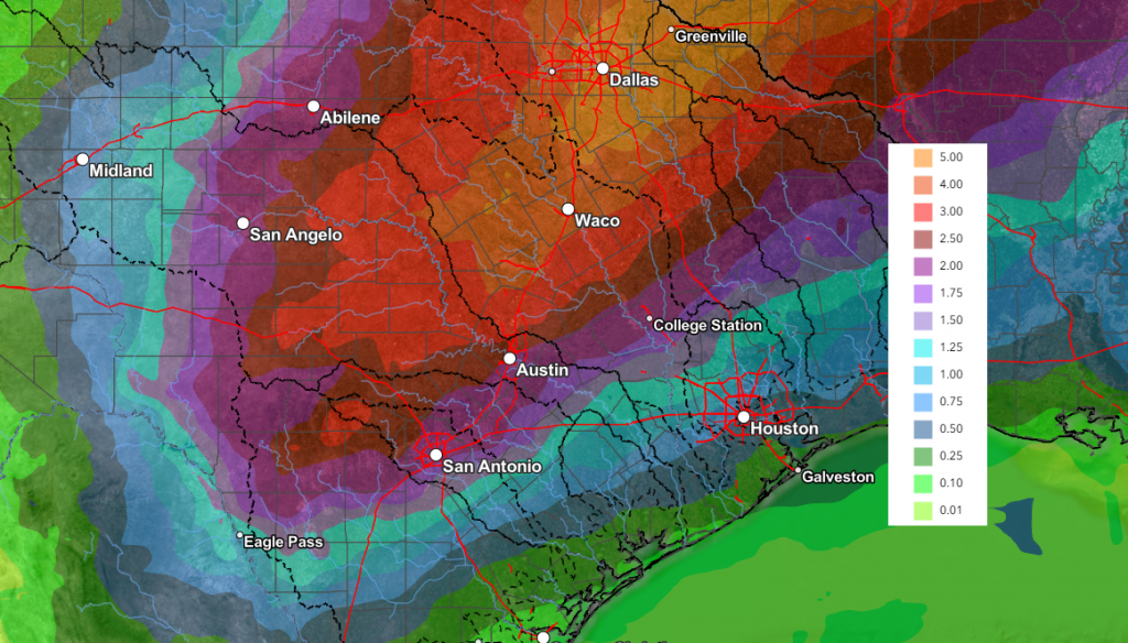
Locally heavy rain will be possible with each of the passing waves of rain. The highest cumulative rain totals through the weekend are forecast to occur across the Hill Country and Central Texas regions, with lower totals to the south. The National Weather Service is predicting totals through 7 pm Monday to average somewhere between 2 and 3 inches, with amounts of 0.5 to 1 inch across the coastal plains.
NWS Rainfall Forecast Valid through 7 pm Monday:
A chance for periods of light rain and isolated thunderstorms will continue next Monday through Wednesday as the upper trough slowly makes its way to the east. Rain amounts through the period are forecast to generally average less than a half inch.
Little change in the temperature is forecast this weekend through the first half of next week. Highs are predicted to be in the upper 70s to low and mid-80s. Low temperatures are expected to be in the low and mid-60s.
Dry and slightly cooler weather is predicted late next week into the following weekend. Expect highs in the upper 60s to low 70s, with lows in the 40s to low 50s.
Time Change Weekend
Daylight Saving Time (DST) will begin this Sunday, March 8, at 2:00 am At that time, we will “spring forward”, setting out clocks ahead one hour to 3:00 am. This change will result in an hour less sleep but will provide more daylight in the evening.
A Total Lunar Eclipse
Early Tuesday morning, March 3rd, Earth’s shadow will swallow the Moon and produce a total lunar eclipse that will be visible across North America. Across Texas, the eclipse will begin just after 4 am, with totality occurring between 5:04 am and 6:03 am. During totality, the moon is expected to turn a crimson color as it creeps through Earth’s shadow.
Unfortunately, widespread clouds late Monday night are expected to limit, if not totally block this celestial event from view.
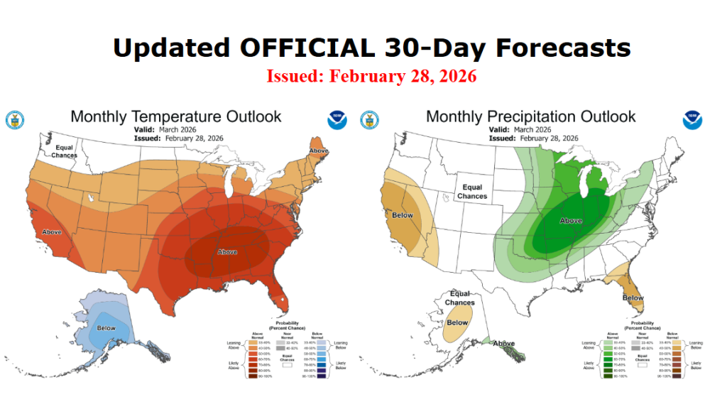
Updated Weather Outlook for March
The National Weather Service released a revised weather outlook for the month of March on Saturday. The updated outlook leans toward above normal rainfall across the northern half of Texas, while showing little trend for above-, below-, or near- normal rainfall across the southern half. NWS forecasters noted the recent chance in the jet stream pattern that is expected to persist through much of the month, creating a more favorable setup for periods of rain. The outlook showed strong odds the temperature will average warmer than normal.
Bob
Social Media