Threat for Heavy Rain Shifting to the Coastal Plains Tuesday into Thursday
June 15, 2026
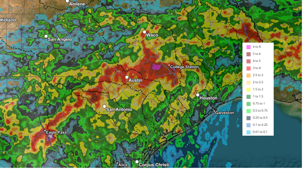
A cold front sinking slowly out of North Texas caused the development of widespread, soaking rains across Much of the Hill Country and Central Texas Sunday night into Monday morning. Rain amounts of 1-3 inches were recorded across much of the area. A zone of 3–4-inch totals stretched from northwest of San Antonio to Johnson City, and east through Austin and College Station. According to LCRA’s Hydromet, some totals more than 5 inches were recorded across parts of Blanco and Gillespie Counties.
NWS Estimate of Rain Falling Between 10 am Sunday and 10 am Monday:
As of mid-afternoon Monday, the heaviest and most widespread rain had shifted southeast of Central Texas, stretching from around San Antonio to Houston. Monday evening through Tuesday afternoon, the heaviest rains are expected to remain across the coastal plains, in the vicinity of the stalled cold front. Across Central Texas and the Hill Country regions, additional light to moderate rain and isolated thunderstorms can be expected Monday night through Tuesday.
For the Hill Country, the probability for rain will only be around 20 percent Monday night, increasing to near 40 percent on Tuesday. Rain amounts through Tuesday evening should average less than a quarter inch.
For the Austin and Central Texas area, the probability for rain Monday night is forecast to be near 40 percent Monday night and near 70 percent on Tuesday.
For the middle Texas coast, the probability for rain Monday night is forecast to be near 70 percent Monday night and near 100 percent on Tuesday and Tuesday night. Periods of heavy rain will be possible.
National Hurricane Center forecasters continue to monitor a trough of low pressure located over northeastern Mexico. This system is producing a large area of disorganized showers and thunderstorms over South Texas. Tropical development is not expected Monday night. However, the system looks like it could re-emerge over the northwestern Gulf late Tuesday or Wednesday, and environmental conditions there are marginally conducive for the formation of a short-lived tropical storm Wednesday into Thursday.
The NHC has raised the probability for tropical development up to 40 percent through Wednesday morning and near 50 percent late Wednesday into Thursday.
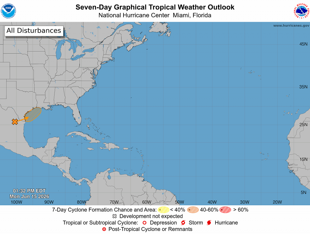
Regardless of tropical cyclone formation, this area of low pressure is expected to pull considerable moisture inland across the coastal plain, resulting in periods of intense rainfall Tuesday into Wednesday which could result in life-threatening flash, urban, and river flooding. In addition, gusty winds to near 30 mph and coastal flooding will also be possible along portions of the northwestern Gulf Coast.
Tropical Storm Watches or Warnings could be required on Tuesday.
For Wednesday, most of the rain will be confined to the coastal region as the low tracks to the northeast. Partly cloudy and generally dry weather is forecast across the Hill Country and Central Texas regions. For the coastal region, showers and possible heavy rain looks to continue through the morning hours, then diminish Wednesday afternoon.
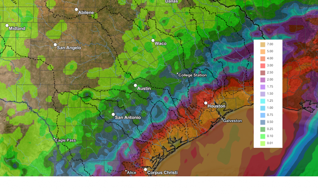
Total rain amounts through Wednesday evening are forecast to average less than a quarter inch across the Hill Country, be between 0.25 and 1 inch across the Central Texas, and average somewhere between 4 and 7 inches across the coastal plains.
NWS Rainfall Forecast Valid through 7 pm Wednesday:
Thursday is shaping up to be a mostly sunny and warm day across the region. There will be a chance for some additional scattered showers and thunderstorms across the coastal region . High temperatures are predicted to be in the low and mid-90s.
A chance for showers and scattered thunderstorms is forecast across the region Friday through Saturday as another weak cold front slides south and stalls somewhere across Central Texas. Forecast rain amounts look to be between 1 and 2 inches. Expect warm and humid conditions with daily highs in the low 90s.
The outlook for next week calls for mostly sunny, dry, and hot weather. Expect daytime high temperatures to be in the mid-90s.
Have a great week!
Bob
Social Media