Thursday Update on the Weekend Winter Storm
JAN. 22, 2026
- A Winter Storm Warning has been posted for the Hill Country and Central Texas regions from early Saturday morning through midday Sunday. A Winter Storm Watch has been posted for the middle Texas coast
- Widespread freezing rain and sleet is forecast to develop across the region Saturday afternoon through early Sunday morning
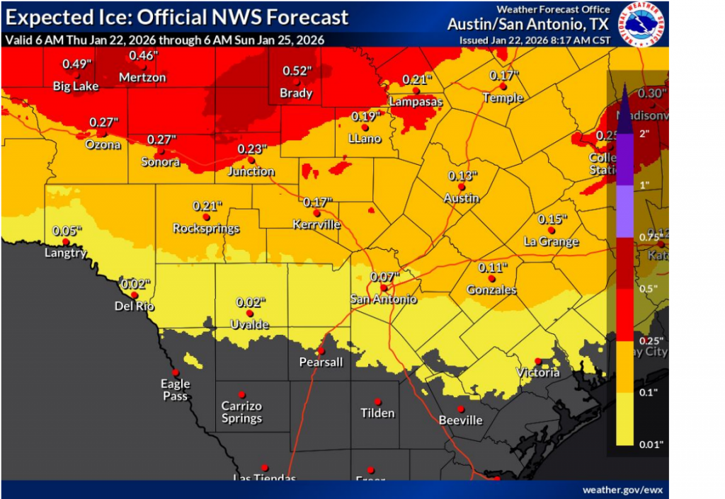
- Total ice accumulations across the Hill Country and Central Texas are forecast to be in the range of one-tenth to one quarter of an inch
- Dangerously cold temperatures and wind chills will move in this weekend and continue into early next week
- Maximum winterization preparation will be needed for this event. All preparations should be completed by Friday evening.
What’s Changed Since Wednesday
- The bitter arctic air is expected to arrive a little later than previously forecast—now Saturday afternoon into Saturday night. The first surge of colder air is still expected to arrive Friday evening and Friday night
- Increased confidence for the development of significant, accumulating ice across the area Saturday afternoon through Sunday morning
- The bitterly cold temperatures and hard freezes now look to extend into Tuesday morning
Discussion
A significant winter weather event will bring potentially significant travel and infrastructure impacts as well as bitterly cold temperatures to all Central Texas and south Texas beginning Friday evening and continuing into early next week. Widespread rain is expected to develop across the area throughout the day on Friday considerable Gulf moisture spreads into Texas ahead of a large trough of low pressure over northern Mexico. The highly anticipated arctic front is forecast to track across the Hill Country and Central Texas regions late Friday evening and Friday night and move off the coast by sunrise Saturday. This is a bit later than previously forecast and means temperatures should stay above freezing for most locations into Saturday morning.
Temperatures are forecast to fall below freezing across the Hill Country Saturday morning and across the Austin/Central Texas area mid to late Saturday afternoon. Towards the coast, the temperature is expected to fall below freezing sometime late Saturday evening and towards midnight.
Widespread light to moderate precipitation is forecast to fall across the region Saturday as a very efficient overrunning setup develops. As temperatures fall below freezing, the precipitation will likely transition to a mixture of rain/freezing rain and sleet. The atmosphere looks to be too warm to support the development of snow. Rounds of light to moderate freezing precipitation are forecast to persist across the area Saturday night into Sunday morning as the tough over Mexico steadily moves to the east. The precipitation is forecast to end from to east Sunday morning as trough pushes into East Texas. The sky should then clear Sunday afternoon into Sunday night.
Significant amounts of ice are expected across the Hill Country and Central Texas regions due to the longevity of the precipitation falling with the temperature at or below freezing. Friday’s forecast shows a strong potential for widespread ice accretion through Sunday morning of 1/10th to 1/4 inch across the region. Totals of ¼ to ½ inch are forecast for the northern Hill Country and the Edwards Plateau. It’s not out of the question some Hill Country locations could see ice accumulations of 0.5 to 0.75 inches.
Impacts to travel will likely begin across the Hill Country and Central Texas regions Saturday afternoon and peak Saturday night into Sunday. Although the precipitation should end Sunday morning, little if any melting is forecast until Monday, and more likely on Tuesday. Impacts will likely linger through the Monday morning commute.
Some improvement may occur on Monday as sunny skies return, but any liquid left on the ground Monday evening will refreeze Monday night into Tuesday morning.
Very cold temperatures will be in place from late Saturday through Tuesday. Some Hill Country and Central Texas locations may see freezing temperatures for more than 48 hours. Bitterly cold temperatures are forecast into Tuesday morning before somewhat milder temperatures develop Tuesday afternoon.
Here’s a rough idea on expected temperatures:
- Lows Saturday morning will include the low 30s across the Hill Country, the mid-30s across Central Texas, and in upper 50s across the coastal plains
- Lows Sunday morning are forecast to be in the middle teens across the Hill Country, near 20 degrees across Central Texas, and near 30 degrees towards the coast
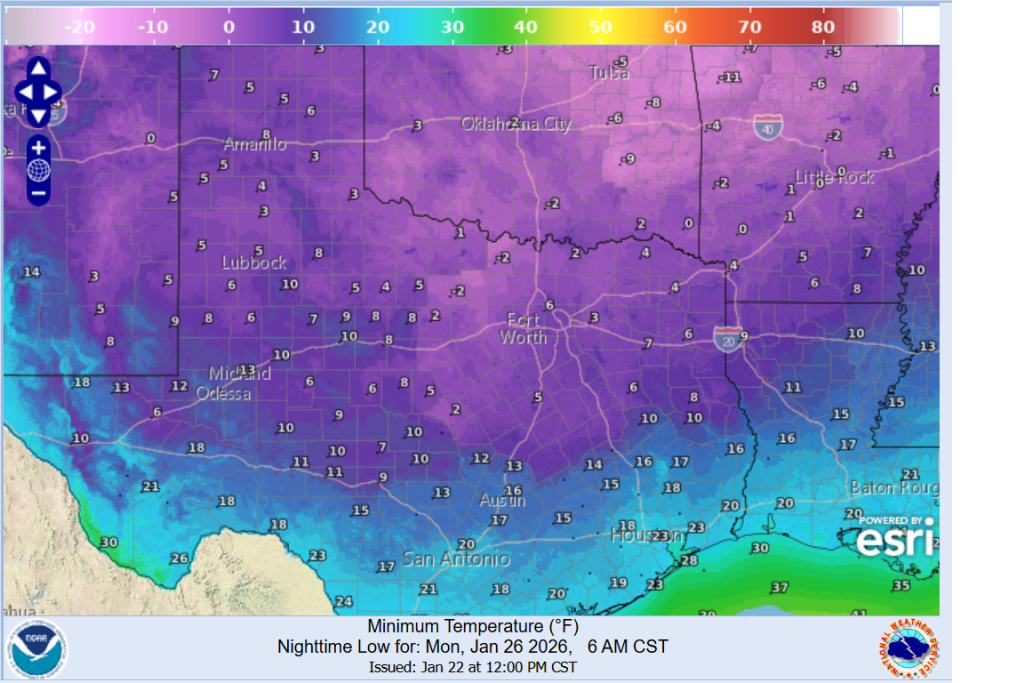
- Lows Monday morning are forecast to be between 5 and 10 degrees across the Hill Country, between 10 and 15 degrees across Central Texas, and around 20 degrees across the coastal plains
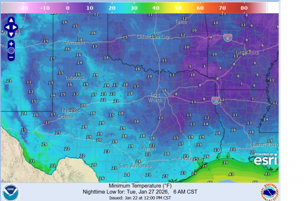
- Lows Tuesday morning are predicted to be between 15 and 20 across the Hill Country, near 20 degrees across Central Texas, and in the low 20s across the coastal plains
- Temperatures Saturday will fall into the upper 20s across the Hill Country, into the mid and upper 30s across Central Texas, and hold in the low 50s across the coastal region
- High temperatures Sunday will range from the mid-20s across the Hill Country to the mid-30s across the coastal plains.
- High temperatures Monday are forecast to be in the mid and upper 30s
- High temperatures Tuesday will be in mid-40s to low 50s
Forecast Low Temperatures Monday:
Forecast Low Temperatures Tuesday morning:
Finalize all of your winter preparations Thursday into Friday. Consider delaying any weekend travel and be prepared for impacts to continue through the Monday morning commute. Wear multiple layers if you go outside this weekend. Check on any vulnerable family, friends, and neighbors. And continue to monitor the forecast for the latest information.
Bob
Social Media