

Triple-Digit Heat and Dry Weather Will Persist throughout the Week
AUG. 17, 2026
Unfortunately, there will be little to no change in the dry and very hot weather pattern this week. A broad, stagnant ridge of high pressure, or heat dome, is forecast to remain over Texas and the south-central U.S. throughout the week and into the upcoming weekend. The heat dome will act to keep rain away from our area while at the same time keep the temperature very hot.
For most areas, it’s been a month since there has been a significant rain and the ground has essentially dried out. The dry ground in combination with sinking air from the heat dome will combine to produce a persistent pattern of very hot temperatures across the area. For most locations, high temperatures this week are predicted to be about 2-3 degrees hotter than they were last week.
Daily high temperatures Monday through Sunday are forecast to be:
- Near 98-100 degrees across the Hill Country
- Near 100-103 degrees across the Austin/Central Texas region
- Near 98-100 degrees across the middle Texas coast
The outlook for next week calls for few changes from the current hot and dry pattern. The center of the intense heat dome is forecast to meander over the area between the Four Corners, the Texas Panhandle, and Far West Texas. The center of the heat dome will be close enough to our area to keep conditions rain-free and temperatures very hot. In fact, high temperatures next week are expected to be very similar to what is forecast for this week.
Looking out a little further into the first week of September, forecasts call for more hot and generally dry weather as the heat dome remains over our area. The heat dome looks to be a little weaker at that time and this could allow for a few spotty showers to make their way north from the coast. High temperatures are predicated to trend about 2-3 degrees lower. Overall, no significant change.
Tropical Weather Outlook
Weather conditions are quiet across the tropical Atlantic, the Caribbean Sea, and the Gulf. National Hurricane Center forecasters were tracking a couple of strong tropical waves late last week, but both fell apart and diminished over the weekend. There are currently no tropical waves showing any promise for development in the near-term.
Tropical cyclone development is not expected over the next seven days.
Rainfall Deficit Across the Region
It’s been a month since we’ve seen a widespread, significant rain across the region. Some locations have seen almost no rain over this period. Rainfall analysis for the past 30 days shows a deficit of 2 to 3 inches for most areas east of Interstate 35, and 1-3 inches for the Hill Country. No appreciable rain is forecast through the end of August.
Rainfall Departure from Normal Past 30 Days:
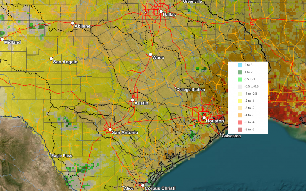
Data courtesy NWS West Gulf River Forecast Center
Have a great week and stay cool!
Bob
Social Media