Turning Cooler this Weekend. Finally, Some Rain is on the Horizon
March 27, 2026
A stout cold front will bring a noticeable change in the weather Friday afternoon and Friday night that will continue through Saturday night. The front is forecast to move across the Hill Country Friday afternoon, reaching the Austin/Interstate 35 corridor in the late afternoon, and pushing southeast to the coast Friday evening. Ahead of the cold front, the temperature is expected to warm to the mid and upper 80s. For Hill Country locations behind the cold front, the temperature is predicted to fall into the upper 60s.
Winds are forecast to increase to 15-20 mph, with occasional gusts to 35 mph Friday night, with similar wind speeds continuing Saturday morning through Saturday afternoon. Wind speeds should decrease to 5-10 mph Saturday night.
A few spotty light rain showers will be possible across the region beginning late Friday evening, continuing till about daybreak Saturday when a weak overrunning pattern sets across the region. The probability for rain will only be near 20 percent and totals, if any, should only be a few hundredths of an inch. Widespread clouds will be in place Friday night through Saturday morning, with the sky becoming partly cloudy Saturday afternoon. A sunny sky is predicted for Sunday.
Noticeably cooler conditions can be expected Friday night through Saturday. Warmer readings look to make a quick return beginning Sunday afternoon.
- Low temperatures Saturday morning will include the upper 40s to low 50s across the Hill Country, the low and mid-50s across Central Texas, and the upper 50s across the coastal area
- High temperatures Saturday will range from the upper 50s to low 60s across the Hill Country, to the mid-60s across Central Texas, to the mid-70s across the coastal plains
- Lows Sunday morning will include the low 50s across the Hill Country, the mid-50s across Central Texas, and the upper 50s towards the coast
- High temperatures Sunday will generally be in the low 80s
- Lows Monday morning will be mostly in the low 60s
For next week, expect a mostly sunny and warm pattern Monday through Wednesday, with daily high temperatures in the upper 80s to 90 degrees, and mid-80s towards the coast.
A slight chance for scattered rain showers and thunderstorms will enter the forecast Wednesday afternoon and continue into Friday when the first in a series of low pressure troughs push east out of the southern Rockies. While this system is forecast to track north of our region, it will be close enough to bring our region scattered rain showers and thunderstorms. The most favorable period for rain looks to be on Thursday.
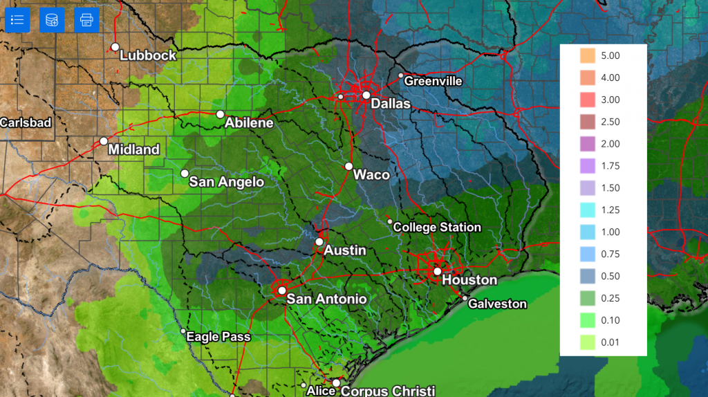
Forecast data calls for rain amounts through Friday to generally average between 0.25 and 0.5 inches.
NWS Rainfall Forecast Valid through Next Friday at 7 pm:
Longer range forecasts call for a chance for scattered rain showers to continue across the region next weekend, with a better chance for rain and thunderstorms occurring late Sunday into Monday.
Warm temperatures are forecast late next week, continuing into next weekend. Forecasts call for somewhat cooler temperatures developing the week of April 6th, with high temperatures falling to the 70s to low 80s, with lows in the 50s.
Have a great weekend!
Bob
Social Media