Turning Much Colder with Widespread Wintery Precipitation this Weekend
JAN. 20, 2026
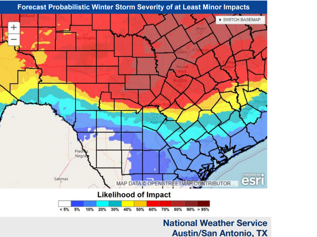
…A Significant Winter Storm Will Affect a Large Portion of the State this Weekend…
Tuesday’s forecast data continues to call for a cold area of high pressure to sink south and move across Texas on Friday. The front is predicted to move across Central Texas late morning and be off the coast by late afternoon. Temperatures are forecast to fall significantly Friday afternoon, with readings predicted to fall below freezing for areas north of Interstate 10 Friday night. By Saturday morning, freezing temperatures are forecast to extend nearly all the way south to the middle Texas coast. Additional cold air is forecast to spread into Texas Saturday through Sunday. Hard freezes are forecast for all areas north of Interstate 10 Sunday morning and for the entire region Monday morning. Slightly warmer temperatures are predicted for Monday and early next week. Do note the temperature for the Hill Country and some Central Texas locations will remain below freezing between Friday night and Monday afternoon.
Here’s a rough idea on expected temperatures:
- Lows Saturday morning will include the low and mid-20s across the Hill Country, the mid and upper 20s across Central Texas, and in the mid and upper 30s across the coastal plains
- Lows Sunday morning are forecast to be in the low and middle teens across the Hill Country, the upper teens to 20 degrees across Central Texas, and the middle 20s towards the coast
- Lows Monday morning are predicted to be in the low teens across the Hill Country, the mid-teens to 20 degrees across Central Texas, and in the low 20s across the coastal plains
- Lows Tuesday morning will generally be in the low and mid-20s
- High temperatures Saturday are forecast to be in the upper 20s across the Hill Country, the low and mid-30s across Central Texas, and in the upper 30s coastal region
- High temperatures Sunday will range from the upper 20s across the Hill Country, to the mid-30s across the coastal plains
- Hight temperatures Monday will range from the mid-30s across the Hill Country, to the mid-40s towards the coast
The Hill Country and Central Texas regions will be on the southern edge of winter storm that is forecast to develop behind the cold air. Widespread light to occasionally moderate precipitation is forecast to occur Friday night through Sunday morning across the region in an efficient overrunning process. A very messy pattern of rain, freezing rain, and sleet is forecast across the entire region. The chances for snow appear to be quite low. The precipitation is forecast to move off to the east Sunday morning, followed by dry weather late Sunday and early next week. Precipitation forecasts are showing a potential for liquid totals of 0.25 to 0.75 inches falling across the region between Friday evening and Sunday morning.
It’s a little too early to have a good handle on the amount of frozen precipitation that can be expected, but with liquid totals of up to 0.75 inches forecast, there is a strong potential for significant ice accumulations across the region beginning Saturday afternoon, continuing through Sunday.
Travel across large portions of the state from late Friday through much of the weekend will become extremely dangerous due to winter precipitation accumulations and brutal cold.
Given the expected cold and potential for wintry weather, stay weather aware and up-to-date with the latest forecast this week as many of the forecast details will likely change over the next few days.
Bob
Social Media