Turning Unusually Warm Sunday then Unusually Cold Monday. No Rain on the Horizon
March 13, 2026
Friday started off somewhat chilly, with readings in the 30s and 40s across the region. According to LCRA’s Hydromet, upper 30s were observed as far south as Bastrop and Fayette Counties. In Austin, the low temperature at Camp Mabry was 46 degrees, while Austin-Bergstrom Airport recorded a low of 37.
Temperatures will steadily warm Friday afternoon and through the weekend as south and southwesterly breezes return off the Gulf. A broad ridge of high pressure in the upper atmosphere covering the southern U.S. is expected to keep the sky sunny through the weekend. On Sunday, the dry line over West Texas is predicted to push far to the east, reaching a position east of the Interstate 35 corridor around mid-afternoon. This will allow dry air and near summer-like temperatures to cover much of the region.
- High temperatures Friday are forecast to warm close to 80 degrees across the region
- High temperatures Saturday will range from around 80 degrees near the coast, to the mid-80s across Central Texas, to the mid and upper 80s across the Hill Country
- High temperatures Sunday are predicted to be near 90-92 degrees across the Hill Country and Central Texas regions, and be in the mid-80s across the coastal region
- Lows Saturday morning will generally be in the low 50s
- Lows Sunday morning are forecast to be generally in the low 60s
After a summer-like day on Sunday, much colder temperatures look to arrive Sunday evening and Sunday night behind a strong cold front. Forecasts call for the front to move across the Hill Country mid to late Sunday afternoon, crossing Central Texas Sunday evening and the coastal region around midnight Sunday night. The atmosphere appears too dry for the development of any rain with the front when it moves across the Hill Country and Central Texas regions. However, a couple of isolated showers and thunderstorms may accompany the front across the coastal region.
Very windy conditions are predicted to develop behind the cold front Sunday evening, continuing through Monday afternoon. Strong cold air advection and pressure rises behind the front are expected to produce strong and gusty northerly winds. Sustained winds of 20-30 mph, with gusts of 40 to 50 mph are predicted Sunday evening through Monday morning. Wind speeds are forecast to decrease to a range of 10-20 mph Monday afternoon.
Sunday’s cold front will drive a cold air mass into the region that is expected to hang around through Tuesday night. In fact, parts of the Hill Country could see a light freeze occur Monday and Tuesday morning.
- Lows Monday and Tuesday mornings are predicted to be in the low and mid-30s across the Hill Country and in the mid and upper 30s across Central Texas.
- For the coastal plains, lows Monday morning are forecast to be in the low 40s. Lows Tuesday morning are predicted to be in the upper 30s.
- Lows Wednesday morning will generally be in the mid and upper 40s
- Highs Monday are forecast to be in the upper 50s
- Highs Tuesday are predicted to be in the upper 60s
Sunny and dry weather will be in place all of next week. The temperature is forecast to warm back to the mid and upper 80s beginning Thursday, continuing through next weekend.
An unusually strong and powerful heat dome is forecast to develop across the western U.S. late next week and persist across the West into the week of March 23rd. This feature looks to bring record-breaking heat to much of the west for several days. Our region will be close to the heat dome, but far enough away to not feel its full furry. High temperatures next weekend and the week of the 23rd are forecast to be close to 90 degrees.
The heat dome is expected to keep the weather dry across our region next week and through most of the week of March 23rd.
Fire Weather Concerns
Elevated to near-critical fire weather conditions are forecast to develop across the Hill Country and the Interstate 35 corridor Sunday afternoon as very dry air spreads in behind the dry line.
Near-critical to critical fire weather conditions are expected across the entire region Monday as dry air and gusty winds persist behind a cold front. The National Weather Service anticipates issuing a Red Flag Warning for much of the area on Monday due to the very high fire danger.
Near-critical fire weather conditions are expected to continue Tuesday.
Increasing Confidence for the Development of El Niño by Summer
The Climate Prediction Center issued their monthly update on ENSO Thursday. In the update, forecasters indicated La Niña is expected to fade within the next month as Pacific Ocean temperatures return to near normal.
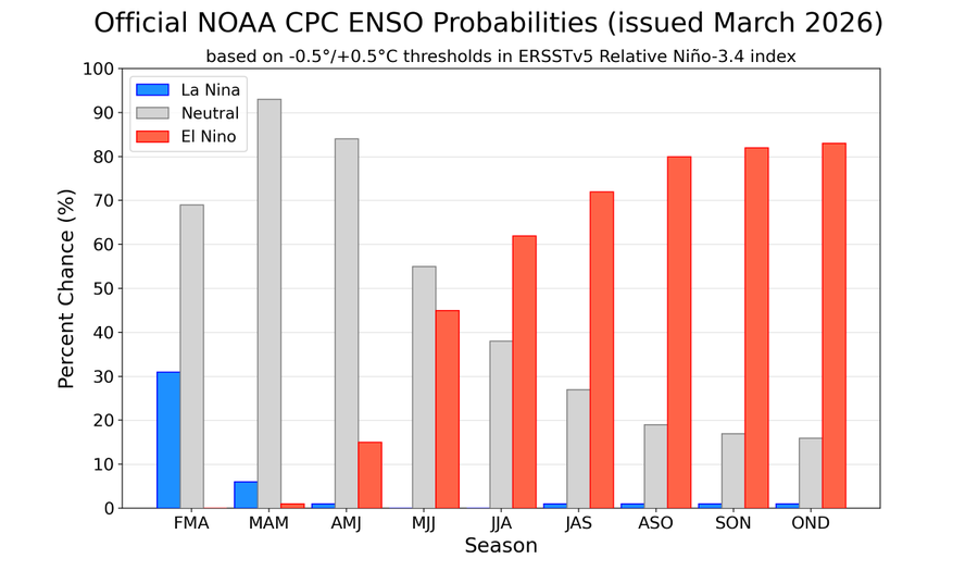
NOAA/CPC states there is a 62% chance El Niño will develop by this summer and lasts through the end of 2026.
For the U.S., El Niño often brings wetter than normal conditions across the southern states during the fall and winter months.
Have a great weekend!
Bob
Social Media