Turning Windy and Colder Sunday Night through Monday
DEC. 28, 2025
…A Wind Advisory Has Been Posted for Most of the Region from 6 pm Sunday through midday Monday….
In advance of the front, it will be another day with scattered sunshine and the temperature warming close to 80 degrees. As of late Sunday morning, the cold front was located just north of the Red River and the northern Texas Panhandle. The front is forecast to reach the northern Hill Country late Sunday afternoon, the Austin area around 7-8 pm, and the coastal region just before midnight. High resolution forecasts indicate a narrow band of rain showers may develop along the cold front once it passes south of Interstate 35. Only very low totals of rain are predicted, with most amounts averaging around a tenth of an inch or less.
Strong winds will develop behind the cold as cold air spills south out the Plains. Forecasts call for northerly winds with sustained speeds of 20-25 mph and gusts to 40-50 mph Sunday night through early afternoon Monday. Wind speeds of 10-15 mph with occasional gusts to 25 mph are forecast Monday afternoon through Monday evening. Much lighter winds are predicted for Tuesday. It is advised to secure any loose objects and holiday decorations before the strong winds arrive Sunday night.
Much colder temperatures will arrive behind the front Sunday night and continue through the first half of the week. However, this will not be an outbreak of arctic air as just a light freeze is forecast across parts of the Hill Country Tuesday morning. The sky looks to remain cloudy Sunday night through Monday night, then clear on Tuesday.
- Lows Monday morning will include the mid and upper 30s across the Hill Country, near 40-42 degrees across Central Texas, and the mid-40s across the coastal plains
- Lows Tuesday morning are forecast to be near 30-32 degrees across the Hill Country, the mid and upper 30s across Central Texas, and the upper 30s across the coastal plains
- Lows Wednesday morning are predicted to generally be in the mid-30s
- Lows Thursday morning are forecast to generally be in the upper 30s
- High temperatures Monday are forecast to be in the upper 40s to low 50s
- Highs Tuesday will be in the low and mid-50s
- High temperatures Wednesday are forecast to be in the mid and upper 50s
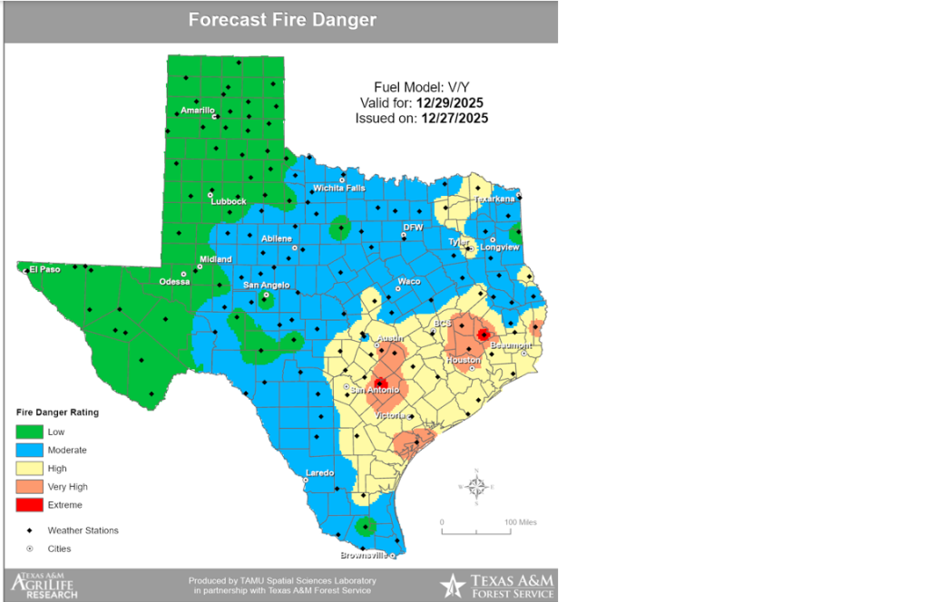
An Increased Fire Danger Monday
The combination of strong winds, very low relative humidity readings, and very dry vegetation is expected to cause near-critical to critical fire weather conditions Monday. Many counties across the Hill Country and Central Texas already have burn bans in place. Please use extreme caution with any open flame or anything that could encourage fire development.
Bob
Social Media