

Turning Windy and Much Cooler Friday
OCT. 15, 2026
Thursday is likely to be the last unseasonably warm day we’ll see for a while. Most areas will see a sunny sky this afternoon with a high temperature near 90-92 degrees.
The first strong cold front of autumn is on the way for Central and South Texas, being driven by a vigorous trough of low pressure tracking east out of the Rockies and a cold dome of high pressure sinking south out of Canada. The latest forecast guidance shows the cold front coming in faster and a bit stronger compared to forecasts from a couple of days ago.
As of late Thursday morning, the cold front had already reached the Texas Panhandle region, where temperatures had fallen into the 50s. Forecasts call for the cold front to sink southeast Thursday afternoon, reaching the northern Hill Country late this evening. The front is predicted to move through the Austin/Interstate 35 corridor shortly after midnight Thursday night, reaching the coastal plains region around sunrise Friday. A few rain showers are forecast along and immediately behind the cold front as it moves southeast. The probability for rain will be near 40 percent. Most totals should average around a tenth of an inch. Clouds will decrease Friday morning, followed by a mostly sunny sky Friday afternoon.
Very strong and gusty winds and much cooler temperatures will develop behind the cold front beginning Thursday night, continuing through Friday night, due to a tight pressure gradient. Forecasts call for sustained northerly winds to be in the range of 20-30 mph, with occasional gusts to 40/45 mph. Wind speeds are forecast to slowly decrease late Friday night into Saturday. Wind speeds on Saturday are forecast to be in the range of 10-20 mph, with occasional gusts to 30 mph. Precautions to outdoor Halloween decorations should be taken Thursday afternoon in advance of the strong winds.
Much cooler temperatures can be expected Friday through Sunday in the wake of the cold front. The coldest night of the period is expected to occur Saturday night when winds diminish across the area. It’s not out of the question some of the low Hill Country valleys could see readings reach the mid and upper 30s!
- High temperatures Friday will include the low and mid-60s across the Hill Country, the upper 60s to 70 degrees across Central Texas, and the low 70s across the coastal plains
- High temperatures Saturday and Sunday are predicted to be near 68-72 degrees
- Low temperatures Saturday morning are forecast to be in the low and mid-40s across the Hill Country, in the upper 40s across Central Texas, and in the low 50s across the coastal plains
- Low temperatures Sunday morning are predicted to be in the low 40s across the Hill Country, the mid and upper 40s across Central Texas, and the upper 40s across the coastal zone
- Lows Monday morning are forecast to be in the upper 40s across the Hill Country and Central Texas, and in the low and mid-50s across the coastal counties
Sunny, dry, and warmer weather is forecast for next week. High temperatures look to warm to the mid-80s by Wednesday.
Fire Weather Concerns
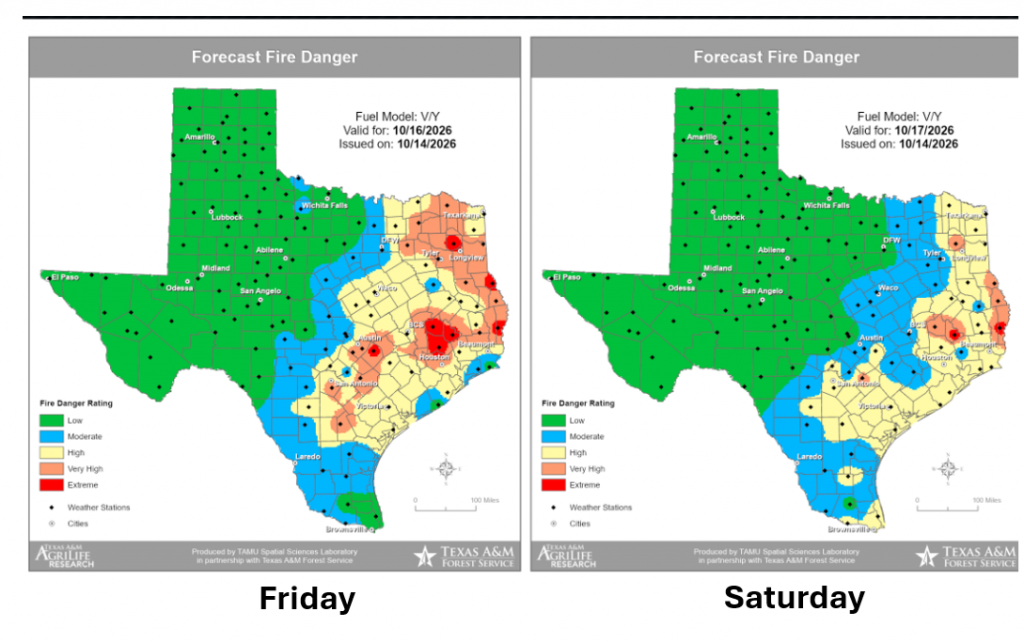
Forecasters are keeping an eye on Friday afternoon and Saturday due to elevated fire weather conditions. Strong winds are forecast both days along with low relative humidity levels. The Texas A&M Forest Service is showing high to very high fire weather danger Friday and a moderate to high fire danger Saturday.
Bob
Social Media