Unseasonably Mild Temperatures Are Forecast through Late Next Week
FEB. 6, 2026
A dry and quiet weather pattern is in place across the region thanks to a large ridge of high pressure stretching from northern Mexico to the Pacific Northwest. The quiet pattern is forecast to continue through the weekend as the ridge slowly spreads east over Texas and the central U.S. Expect a sunny sky Friday afternoon and Saturday. High-level clouds will increase on Sunday causing the sky to be mostly sunny. Very spring-like temperatures are forecast!
- High temperatures Friday are predicted to near 78-82 degrees
- High temperatures Saturday and Sunday look to be in the mid and upper 70s
- Low temperatures Saturday and Sunday mornings will generally be in the mid and upper 40s
- Lows Monday morning are expected to be in the low and mid-50s
Some changes in the weather are forecast to take place early next week. Although the jet stream will be flowing from southwestern Canada to the northeastern U.S., forecasters will be monitoring a trough of low pressure in the upper atmosphere that will be located off the coast of Baja, California. The trough is predicted to track east across northern Mexico Monday, then turn northeast and move across Texas on Tuesday. Clouds will increase across the area late Sunday into Monday as the approaching trough pulls clouds and moisture north from the Gulf. Periods of mostly light rain showers and perhaps an isolated thunderstorm or two are forecast to develop across the region Monday night, continuing through Tuesday afternoon. The rain is expected to taper off by Tuesday evening as the trough exits to the northeast.
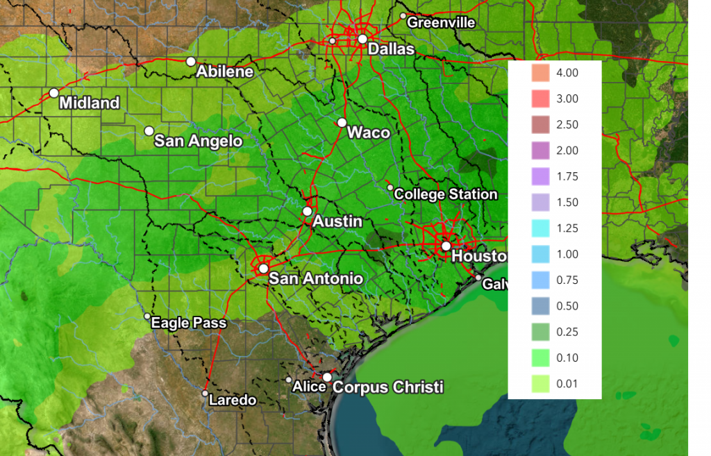
Rain amounts from this system are forecast to be low, with most totals averaging only around a quarter inch or less.
NWS Rainfall Forecast Valid through 6 pm Wednesday:
High temperatures Monday and Tuesday are predicted to be in the mid-70s.
Mostly sunny weather and mild temperatures are forecast next Wednesday and Thursday in the wake of the departing upper trough. High temperatures look to continue in the mid-70s, with lows in the low and mid-50s.
Another chance for rain appears to be taking shape for next Friday into Saturday as a second Pacific trough of low pressure moves east from the Desert Southwest. This next system is expected to pull moisture north from the Gulf, resulting in the development of scattered rain showers across the region. As of now, rain amounts with this next system are only expected to be around a quarter inch. Sunny and dry weather is forecast to return next Sunday and continue into the week of the 16th.
Long-range forecasts don’t show the return of any arctic air into our region through at least the third of February.
Jupiter and Saturn are Currently the Only Two Planets Visible
If you’re a skywatcher, you may have noticed the lack of visible planets lately. Right now, only Jupiter and Saturn are visible. The others are hidden by the sun. You can find the bright planet Jupiter ascending in the eastern sky about two hours after sunset. Saturn will be there, too, but less bright and more to the west. Saturn will be sinking closer to western horizon each evening over the next couple of weeks. Mercury, Venus and Mars have all been traveling behind the sun as seen from Earth, but they’ll return to the evening sky later this month!
Have a great weekend!
Bob
Social Media