Warmer and More Humid Weather Returning. A Chance for Thunderstorms by Friday
April 22, 2024
Monday started off pleasantly cool, with temperatures in the 40s and low 50s. According to LCRA’s Hydromet, several spots around Brownwood recorded lows near 40 degrees. The Canadian air mass which allowed for the cooler readings this morning and over the weekend is unfortunately already on its was out. Southerly breezes have returned, meaning warmer and more humid air will soon be returning to the area.
Dry weather is forecast this afternoon through Thursday as a stable ridge of high pressure spreads over Texas out of Mexico and the Desert Southwest. At the surface, light southerly breezes are predicted for this afternoon and tonight. Wind speeds are forecast to increase to 10-15 mph, with gusts to 25 mph beginning Tuesday morning. The breezy conditions look to continue Tuesday night through Wednesday.
Expect a mostly sunny sky Monday afternoon. Low clouds look to develop across the eastern Hill Country and most of Central Texas after midnight Monday night continuing through Tuesday morning. The sky is forecast to become partly cloudy Tuesday afternoon. A similar pattern can be expected Tuesday night through Thursday.
- High temperatures Monday are forecast to be in the low 70s.
- Lows Tuesday morning are predicted to be in the low 50s across the Hill Country, and in the mid-50s at most other locations.
- High temperatures Tuesday are forecast to be near 78-80 degrees.
- Lows Wednesday morning will generally be in the mid-60s.
- High temperatures Wednesday and Thursday are forecast to be in the low and mid-80s.
- Lows Thursday morning will be near 68-70 degrees.
Some changes in the weather pattern are forecast to take place Friday and through the weekend as the ridge of high pressure over Texas weakens and shifts to the east. At the same time, forecasters will be closely monitoring a couple of waves of low pressure that are predicted to move from the southern Rockies to the central Plains. These two systems are forecast to bring a few rounds of rain showers and strong to severe thunderstorms to northern Texas and the Plains states Thursday through Sunday. Some of these storms could possibly extend south into the northern half of the Hill Country and Central Texas during this period.
Thursday’s weather is expected to be partly to mostly cloudy, breezy and warm as moisture increases off the Gulf of Mexico. Southerly winds will be gusting up to 30-35 mph. Expect a high temperature in the low 80s. Scattered thunderstorms are forecast to develop along the dry line across West Texas Thursday afternoon. There will be a 20 percent chance for a few of these storms to track east to parts of the northern half of the Hill Country late Thursday afternoon. Some of these storms could possibly be strong to severe.
Friday will see a slightly better chance for scattered thunderstorms across the Hill Country and most of Central Texas as the dry line shifts east to the eastern Hill Country. Forecasts call for scattered thunderstorms to develop across the area by afternoon. The probability for thunderstorms will be near 40-50 percent. Some of these storms could be strong to severe, with the primary severe weather threats being large hail and damaging winds. Rain amounts are predicted to average around a quarter inch. As of now, the thunderstorms are forecast to remain north of the coastal plains. Gusty winds look to continue. Friday’s temperature is forecast to reach the low 80s.
Another chance for scattered thunderstorms is forecast to take place Saturday through Sunday night as the second wave of low pressure drags a Pacific cold front east across the Hill Country and into Central Texas. The probability for rain is predicted to be near 30-40 percent. Once again, some of the storms could be strong to severe. Weekend rain amounts are predicted to average around a quarter inch. Expect a partly to mostly cloudy sky both days. High temperatures are forecast to be in the upper 80s, with lows only in the low 70s. The majority of the rain activity should stay north of the coastal plains region.
NWS 7-Day Rainfall Forecast Valid through 7 pm, Monday 4/29
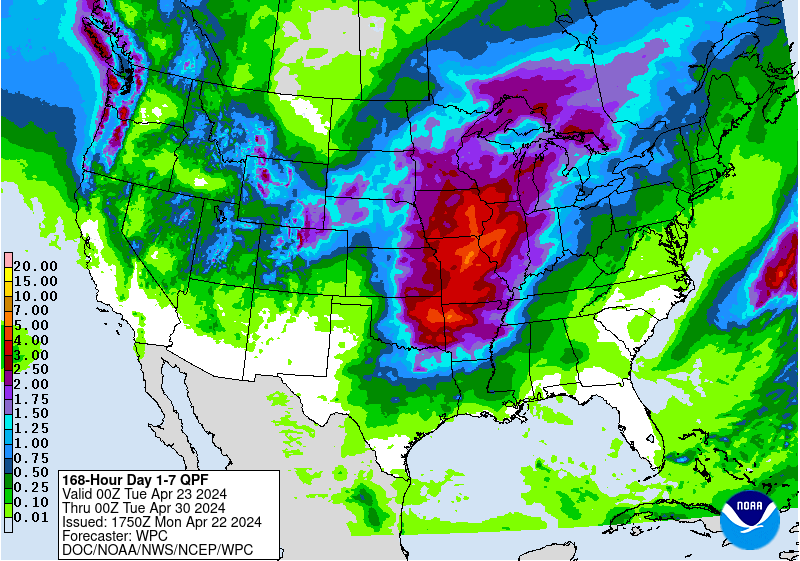
Looking ahead to next week, forecast call for mostly sunny and dry weather Monday and Tuesday. A chance for scattered thunderstorm will return to the forecast Wednesday and continue through late week as a large trough of low pressure sets up across the western U.S., causing the dry line to become very active. Expect warm temperatures, with highs in the mid and upper 80s, and lows around 70 degrees.
Bob
Social Media