Warmer Temperatures Returning this Week. A Chance for Rain Over the Weekend
NOV. 10, 2025
Sunday’s cold front brought chilly temperatures to the region Monday morning. According to LCRA’s Hydromet, a light freeze occurred across a large part of the Hill Country, while Central Texas and the coastal region stayed above freezing. Low temperatures Monday morning were generally in the upper 20s to mid-30s across the Hill Country, in the mid-30 to mid-40s across Central Texas, and in the low to mid-40s across the coastal plains. The northern Hill Country region between San Angelo, Goldthwaite, and Abilene appears to have recorded the coldest readings, as the temperature here dipped to the mid and upper 20s. LCRA’s lowest gauge temperature was 23 degrees at a location near the town of May, in northeastern Brown County. In Austin, the minimum temperature at Camp Mabry was 41 degrees and the low at Austin-Bergstrom Airport was 36 degrees.
Our weather will likely stay sunny and dry through the end of the week as our region remains under the influence of a broad, stable ridge of high pressure in the middle and upper atmosphere. At the surface, the center of the cold air mass was situated across Central Texas as of early Monday afternoon. The center is forecast to begin shifting off to the east Monday night into Tuesday, causing our winds to shift back out of the south. Relative humidity readings are forecast to remain quite low through Tuesday, then increase Wednesday through Friday. As a result, elevated Fire Weather conditions are forecast for the coastal region Monday afternoon, and for the entire region on Tuesday. Fire weather conditions should improve somewhat Wednesday through Friday due to higher relative humidity readings. (See the fire weather section below for more details).
We’re looking at one more chilly period from Monday night into early Tuesday morning before milder readings return Tuesday afternoon and Tuesday night. All the area should stay above freezing Monday night.
- Lows Tuesday morning are predicted to be in the mid and upper 30s across the Hill Country and Central Texas regions, and in the upper 30s to 40 degrees across the coastal plains.
Warmer temperatures and breezy conditions are forecast Tuesday through Thursday. Expect southerly breezes at 10-15 mph, with occasional gusts to 25/30 mph.
- High temperatures in the mid-70s Tuesday, look to warm to the low 80s Wednesday, and the mid-80s Thursday and Friday
- Low temperatures Wednesday morning will range from around 48-50 degrees across the Hill Country, to the mid-50s near the coast
- Lows Thursday through Saturday morning will generally be in the upper 50s to low 60s
A chance for rain showers and scattered thunderstorms will enter the forecast for the upcoming weekend when a trough of low pressure out of the Pacific tracks east across northern Mexico and eventually across northern Texas. With a stout southerly flow off the Gulf and a favorable fetch of moisture preceding the trough, conditions appear favorable for the development of widespread rain showers and scattered thunderstorms. The rain is forecast to end from west to east on Sunday as the trough exits to the east.
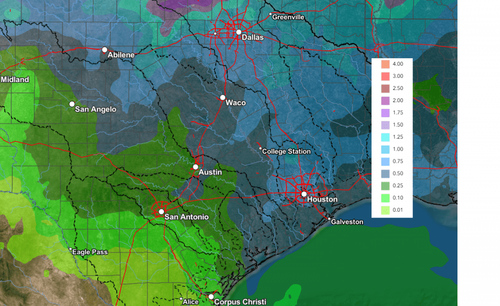
The probability for rain is predicted to be near 30 percent Saturday, and near 50 percent on Sunday. While modest instability should be sufficient to support thunderstorm activity, the overall parameter space presently appears unsupportive of strong or severe thunderstorms. However, this could also change depending on alterations in the trough’s speed and trajectory. As of today, rain amounts from this system are forecast to average between 0.25 and 0.5 inches, with some isolated, heavier totals.
NWS Rainfall Forecast Valid through 7 pm Monday:
Mild temperatures will continue this weekend, with highs in the 70s to low 80s, and lows in the upper 50s to low 60s.
Extended Forecast
The outlook for next week calls for continued mild temperatures, with highs generally in the 70s and lows in the 50s. Mostly sunny weather is predicted Monday through Wednesday. Forecasts point to the development of another chance for rain next Thursday and Friday as a new Pacific trough of low pressure moves across the area from the west.
No unusually cold temperatures are predicted through the end of the month.
Fire Weather Outlook
The combination of very dry air and gusty winds across the coastal plains region will cause critical fire weather conditions for areas along and south of Interstate 10 through late afternoon. The National Weather Service has posted a Red Flag warning for this area through 6 pm Monday. Elevated fire weather conditions will be in place across the rest of the region.
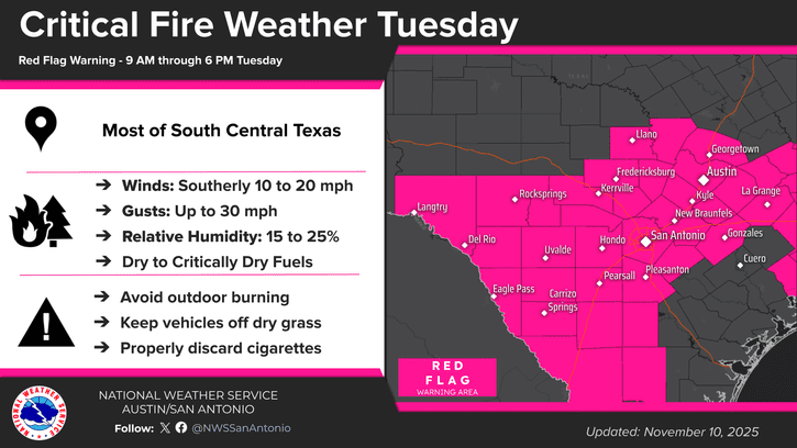
Critical fire weather conditions are forecast across the entire region Tuesday due to very low relative humidity levels and gusty winds to near 25/30 mph. The National Weather Service has posted a Red Flag warning for most of the Hill Country and all Central Texas, plus Colorado County from 9 am through 6 pm.
Fire weather concerns should ease somewhat Wednesday through Friday as relative humidity levels increase.
Tropical Weather Outlook
Weather conditions remain quiet across the tropical Atlantic. Tropical cyclone development is not expected over the next seven days.
Have a great week!
Bob
Social Media