Warmer Temperatures Returning Tuesday. Next Chance for Storms Expected Thursday Night
March 20, 2023
Weekend temperatures were quite chilly, but fortunately, few locations recorded readings at or below freezing. The chilly air mass that’s been in place since Friday is now on its way out and warmer temperatures are expected beginning Monday night.
A few light showers will be possible Tuesday morning, but the best chance for rain this week looks to occur Thursday night into Friday morning when a Pacific cold front moves across the state. Some severe storms will be possible.
Long-range forecasts don’t show any additional cold air spreading into Central Texas over the next couple of weeks.
This Afternoon
Widespread low clouds are forecast to hang tough across the area as southerly breezes pull moisture inland off the Gulf. Expect south and southeasterly breezes in the range of 10-15 mph, with occasional gusts to 25 mph. Afternoon temperatures are forecast to peak around 60 degrees across most of the area.
Monday Night through Tuesday Night
Breezy southerly winds with speeds of 10-15 mph are forecast to continue overnight, pulling additional moisture inland from the Gulf of Mexico. With moisture levels increasing, some patchy drizzle will be possible after midnight.
->Lows Tuesday morning are forecast to be in the low 50s across the Hill Country and Central Texas, and in the mid to upper 50s near the coast.
Tuesday morning will feature widespread clouds and even some spotty light rain showers. The sky is expected to stay mostly cloudy Tuesday afternoon. The breezy conditions will continue, with speeds in the range of 10-20 mph, with occasional gusts to 30 mph.
->High temperatures Tuesday are forecast to be in the low 70s.
Cloudy, breezy and mild weather is forecast Tuesday night.
->Lows Wednesday morning are forecast to be in the low and mid-60s.
Wednesday
Wednesday’s weather will feature widespread low clouds through the morning hours, followed by a partly cloudy to mostly sunny sky in the afternoon. Expect breezy south winds in the range of 10-20 mph, with occasional gusts to 35 mph.
High temperatures Wednesday are forecast to be in the low 80s.
Thursday through Friday
Forecasts call for a trough of low pressure to track from the southern Rockies to the southern Plains states Thursday into Friday. The trough will help push a Pacific cold front across the state late Thursday into Friday morning.
Expect a partly to mostly cloudy sky and breezy conditions Thursday afternoon. In advance of the cold front, there will be a 40 percent chance for scattered rain showers and isolated thunderstorms mainly across the Hill Country and Central Texas regions Thursday afternoon into Thursday evening. Some of these thunderstorms may be strong to severe, producing large hail and damaging winds.
Thursday’s high temperature is predicted to be near 80-82 degrees.
The Pacific cold front is forecast to move across the Hill Country sometime between late Thursday evening and midnight Thursday night. The front is forecast to move across Central Texas and the middle Texas coast after midnight Thursday night, exiting off the coast Friday morning. Forecasts call for an area of rain showers and strong to severe thunderstorms to develop along and just behind the cold front when it moves across the area. The rain is forecast to taper off from west to east early Friday morning as drier air spreads in behind the cold front.
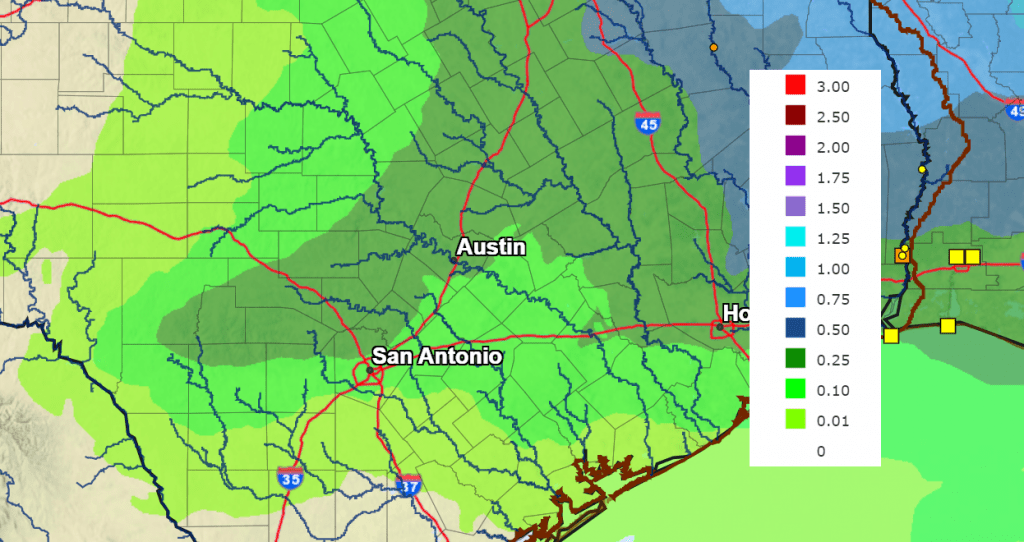
Rain amounts between Thursday afternoon and Friday morning are not expected to be very heavy, with most totals averaging around a quarter inch. Some isolated totals to around a half inch will be possible.
Lows Friday morning will be in the 50s. High temperatures Friday are forecast to be in the upper 70s.
Lows Saturday morning will range from the mid-40s across the Hill Country, to the mid-50s across the coastal plains.
NWS Rainfall Forecast for the Period 7 pm Monday through 7 pm Saturday:
Saturday
Sunny and very pleasant weather is forecast.
High temperatures will be around 78-80 degrees.
Lows Sunday morning will range from the low 50s west, to around 60 degrees near the coast.
Sunday through Monday
Expect a partly cloudy sky with a slight chance for rain showers and isolated thunderstorms both days as a weak trough of low pressure skirts the northwestern part of the state. Rain amounts, if any, will only average around a tenth of an inch. Expect high temperatures around 80 degrees, with lows in the upper 50s to low 60s.
Next Tuesday through Thursday
Expect partly cloudy, breezy and warm conditions, with high temperatures in the low 80s, and lows in in the upper 50s to low 60s.
Forecasts point to a chance for rain showers and thunderstorms developing late next week as a Pacific trough of low pressure approaches from the west.
Bob
Social Media