Warmer this Weekend. Small Chances for Rain through Much of Next Week
March 1, 2024
Friday started off rather chilly across the area—especially across the Hill Country where the sky cleared, allowing the temperature to fall to the upper 20s to mid-30s. According to LCRA’s Hydromet, the lowest recorded temperature was 27 degrees at several gauges located between Junction and Mason. Lows across Central Texas were generally in the mid-40s, while the coastal area saw readings reaching the upper 40s to low 50s.
After a couple of cloudy, cool days, we’re now looking at the return of sunshine and warmer weather for Friday and the weekend. Forecasts call for a stable ridge of high pressure over northern Mexico to spread east across Texas this weekend, which is expected to produce mostly sunny and dry weather pattern.
Light northeasterly breezes Friday afternoon are forecast to become southerly Friday night and through the weekend. Due to this moist flow off the Gulf, forecasts call for the development of widespread low clouds across the area late Friday night through about mid-morning Saturday. A similar pattern of late night and morning low clouds is forecast Saturday night into Sunday morning and also Sunday night into Monday morning.
The combination of sunshine and southerly breezes will bring a return spring-like temperatures this weekend.
- High temperatures Friday are forecast to generally be in the low and mid-70s.
- Lows Saturday morning are predicted to be close to 50 degrees.
- High temperatures Saturday are forecast to be near 80-82 degrees.
- Lows Sunday morning will be in the mid-50s across the Hill Country, and near 60 degrees at most other locations.
- High temperatures Sunday are forecast to be near 80-82 degrees.
- Lows Monday morning will be in the low 60s.
Next Week
Forecasts call for a slight change in the weather pattern next week as a series of weak low pressure troughs track east across the southern Plains states. The first of these troughs is predicted to push east across North Texas/southern Oklahoma Monday afternoon into Monday night. This system is expected to cause the development of scattered rain showers and isolated thunderstorms beginning Monday afternoon, continuing through Monday evening. The most favorable for area for rain is expected to be for areas along and to the east of Interstate 35. The probability for rain will range from 20-30 percent across the Hill Country, to around 40 percent across Central Texas and near 50 percent across the coastal plains. A couple of strong thunderstorms will not be out of the question. The chance for rain is forecast to end by midnight Monday night.
Rain amounts Monday through Monday evening at best are forecast to only average around a quarter inch.
Partly cloudy and dry weather is forecast Tuesday in the wake of the departing upper trough.
Forecasts call for a 30-40 percent chance for scattered rain showers and isolated thunderstorms beginning Wednesday afternoon, continuing through next Friday as additional waves of low pressure push east across the southern Plains. The most favorable period for rain looks to occur Friday afternoon and Friday night ahead of Pacific cold front. Dry and slightly cooler weather is predicted in the wake of the front next weekend.
Rain amounts between Wednesday afternoon and Friday night are forecast to average around a quarter inch. Some isolated heavier totals will be possible.
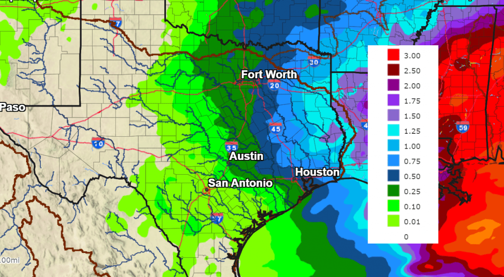
NWS Seven-Day Rainfall Forecast, Valid through 6 pm Next Friday:
Mild temperatures are forecast next week, with highs in the 70s to low 80s. Lows are forecast to the 60s. Slightly cooler weather is forecast next weekend, with highs in the 60s and lows in the upper 40s to low 50s.
Looking out into the week of March 11th, mild spring-like temperatures look to continue.
February Climate
February’s climate was characterized by much warmer than normal temperatures and slightly below normal rainfall. Temperatures generally averaged between 4 and 6 degrees above normal! In Austin, Camp Mabry’s average temperature of 60.7 degrees ranked as the 7th warmest February on record dating back to 1897.
February rainfall for most areas was generally around 0.5 to 1 inch below normal. For Austin-Camp Mabry, February 2024 was the 35th driest February on record.
Have a good weekend.
Bob
Social Media