

Weather Trending Sunny, Dry, and Mild Tuesday through Saturday
NOV. 9, 2026
Cloudy, cool, and wet weather has gripped the southern half of Texas since Saturday. A nearly stationary trough of low pressure parked over Far West Texas has been producing waves of rain showers and scattered thunderstorms, with the heaviest rains occurring across the Concho Valley/Edwards Plateau regions along with the Rio Grande Plains. Doppler radar estimates and rain gauge totals show amounts have generally averaged between 3.5 and 5 inches over the area between Rocksprings, Junction, and Menard. Further east and north, the amounts have been considerably less. In fact, most totals east of Interstate 35 have only averaged less than a half inch.
NWS Estimate of Rain Falling between 6 am Saturday and 6 am Monday:
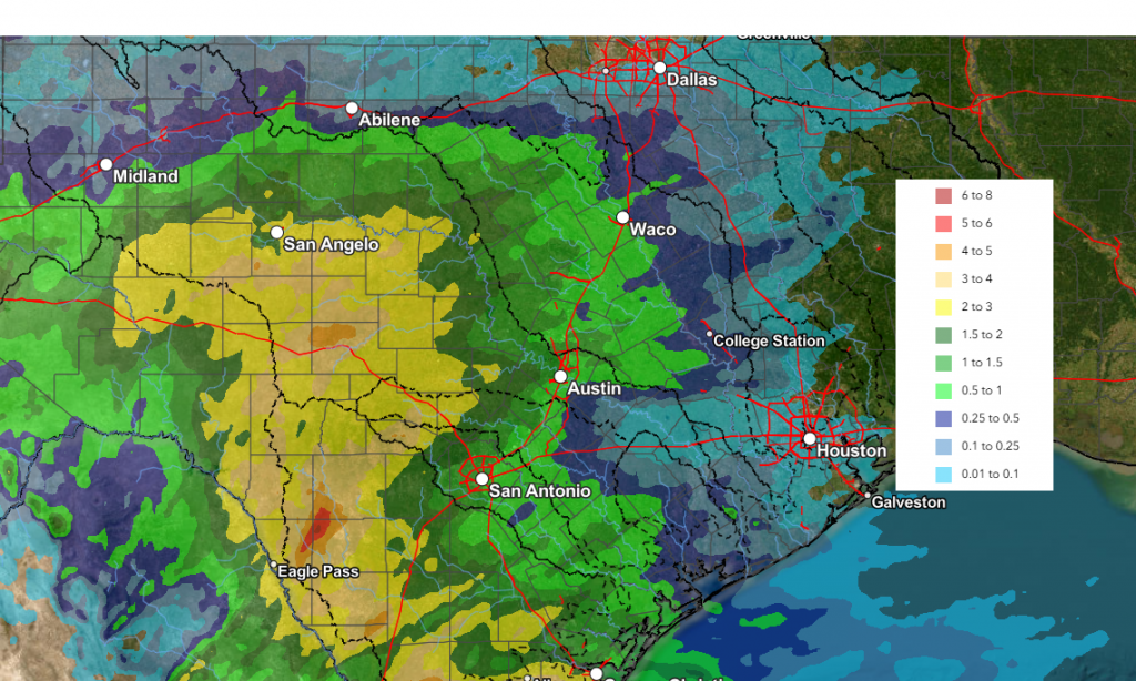
Data courtesy National Weather Service West Gulf River Forecast Center
Monday’s analysis showed the stalled trough of low pressure was finally beginning to move off to the east and northeast. Forecasts call for the trough to finally exit our region sometime Tuesday morning. Until the trough moves out, additional waves of light to moderate rain showers are predicted to move across the region Monday afternoon through Monday night. The rain is forecast to become lighter in intensity Monday night, with the rain then tapering off from west to east late Monday night into Tuesday morning. The probability for rain will be near 70 percent Monday afternoon, decreasing to 40 percent Monday night.
Forecasts call for the highest totals of rain through Tuesday are expected to occur across the Edwards Plateau/western Hill Country region where the best intersection of moisture and atmospheric lift will occur. Here, additional totals of 1-1.5 inches will be possible. Elsewhere, totals through Tuesday morning are forecast to generally average around a half inch, with isolated totals to near 1 inch possible.
- Monday’s afternoon’s temperature is forecast to hold nearly steady in the low and mid-60s
- Lows Tuesday morning will generally be in the mid and upper 50s
One thing to monitor Monday night will be the development of mist/fog. Patchy fog will be possible across the region late Monday night into early Tuesday morning due to the wet ground and light winds.
Tuesday’s weather shows the potential for a few sprinkles of light rain across the region when a second, weak trough of low pressure moves over the area. However, most locations should remain dry. Expect a partly cloudy to mostly sunny sky, with a high temperature near 70-72 degrees.
A dry, stable northwesterly wind flow looks to develop across Texas Wednesday, continuing through late week as a deep trough of low pressure develops across the eastern U.S. This northwesterly flow will help to pull a couple of Pacific cold fronts across Texas, with the first arriving late Wednesday, and the second one sometime late Thursday or early Friday. No rain is predicted with either front. In addition, no significant change in the temperature is expected. Look for a sunny sky Wednesday through Saturday.
- Wednesday is shaping up to be the warmest day of the week, with high temperatures in the mid and upper 70s
- High temperatures Thursday through Saturday are forecast to be in the low and mid-70s
- Lows Thursday morning night are predicted to be near 50-52 degrees
- Lows Friday and Saturday mornings are forecast to be near 48-50 degrees
Extended forecasts show an increasing likelihood another mid-level trough of low pressure tracking from northern Mexico into Texas next Sunday and Monday. This system is expected to pull clouds and moisture back into the state. A chance for showers will begin next Saturday night and continue into Monday. As of now, rain amounts from this next system are forecast to remain under a half inch.
NWS Rainfall Forecast for the Period 6 pm Saturday 11/14 – 6 pm Monday 11/16
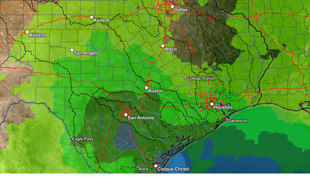
Forecasts call for dry weather next week Tuesday and Wednesday, with another chance for rain developing the second half of next week. No significant change in the temperature is predicted for next week. Highs will continue in the 70s, with lows in the upper 50s to low 60s.
Tropical Weather Outlook
Weather conditions are quiet across the entire Atlantic basin. There are no systems in place that pose a threat for tropical development over the next seven days.
Early Thanksgiving Weather Ideas
It’s way too early yet to have a concise outlook for Thanksgiving. However, based on some of the long-range model solutions, I think we can gather some general ideas on what kind of weather to expect. As of now, no significant change in the temperature is expected. There don’t appear to be any cold outbreaks in store for Texas during the last week of November. We may see rain over at least a part of the long holiday weekend. The subtropical jet has recently become active across the southern U.S., and it looks to bring periods of clouds and rain to our area every few days.
More details about Thanksgiving weather will become clearer over the next week or so. Stay tuned.
Have a good week!
Bob
Social Media