Widespread Rain and Cooler Temperatures Expected this Weekend
April 2, 2026
A large area of rain and thunderstorms pushed east out of West Texas late Wednesday night and spread across the Hill Country and most of Central Texas early Thursday morning. Totals were generally in the range of 0.5 to 1.5 inches, although a pocket of 2-2.5-inch totals occurred over the area between Mason and Eldorado. LCRA’s highest gauged total was 2.90 inches at a location in eastern Schlicher County, to the northwest of Fort McKavett. The area of rain turned to the northeast when it approached SH 77 about mid-morning Thursday. As a result, little to no rain occurred across the coastal plains.
It’s interesting to note one of storms that occurred Thursday morning across Lee County appears to have produced a weak tornado. The National Weather Service determined a weak tornado touched down briefly in Lee County Thursday morning based on photos and drone footage received by the Lee County Office of Emergency Management along with radar analysis. The tornado formed roughly six miles southwest of Giddings, near CR 208 and FM 2239, and moved northeast into Giddings before dissipating. Sporadic damage was observed to power lines, tree limbs, and tin sheds, as well as some small sections of tin roofs and eaves peeled back.
Thursday afternoon through Friday afternoon, dry and warm weather is forecast for most areas. However, an isolated afternoon shower or two cannot be ruled out across the coastal region. Thursday’s temperature should reach the low and mid-80s, warming to the mid and upper 80s on Friday.
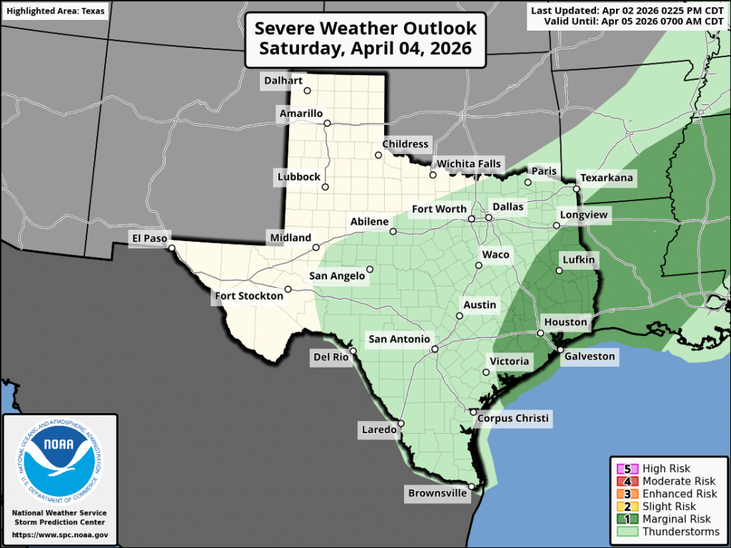
Another period of rain showers and scattered thunderstorms is forecast across the region beginning late Friday as a potent trough of low pressure tracks northeast from the southern Rockies. The trough will help push a cold front south across the state during the day on Saturday. The front is predicted to move across the Hill Country Saturday morning and the Austin/Central Texas area Saturday afternoon. The front is forecast to slowly push south through the coastal region Saturday night.
In advance of the trough and front, scattered thunderstorms are forecast to develop late Friday afternoon across West Texas along the dry line. These storms are predicted to track to the east and could move over parts of the western Hill Country Friday evening. Some of these storms could be strong to severe. Elsewhere, a separate area of scattered showers and scattered thunderstorms is forecast to develop across parts of the Hill Country and Central Texas after midnight Friday night and continue through Saturday morning as the atmosphere grows increasingly moist and unstable. A widespread area of rain showers and scattered thunderstorms is then predicted to develop along and behind the cold front over the Hill Country and Central Texas regions Saturday and Saturday night. For the coastal region, widespread showers and scattered thunderstorms will increase in coverage Saturday afternoon and continue through Saturday night.
The threat for widespread severe storms Saturday appears low. However, a couple of strong to severe storms cannot be totally ruled out. The Storm Prediction Center has placed southeast Texas under a 1 out of 5 risk for severe storms on Saturday
Forecasts call for the rain to taper off across the northern Hill Country early Sunday. For the remainder of the Hill Country, Central Texas, and the middle Texas coast, periods of rain look to continue Easter Sunday, Sunday night, and into early Monday morning as a weak overrunning pattern sets up behind the cold front. The probability for rain will be near 40-50 percent.
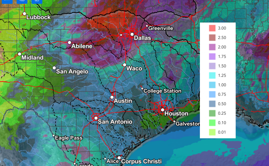
Rainfall forecasts through Monday call for widespread totals of 1-1.25 inches. A few isolated heavier totals will be possible—mainly across the western Hill Country.
NWS Rainfall Forecast Valid through 7 pm Tuesday:
Noticeably cooler temperatures will follow the cold front Saturday, with the cooler readings expected to hang around into middle of the week.
- Lows Sunday morning will include the upper 40s across the Hill Country, the low 50s across Central Texas, with mid and upper 60s towards the coast
- High temperatures Easter will range from the low 60s across the Hill Country, to the upper 60s near the coast
- Lows Monday morning will again be in the upper 40s to low 50s across the Hill Country and Central Texas regions, with mid-50s towards the coast.
- High temperatures Monday will be in the mid and upper 60s
- Lows Tuesday and Wednesday mornings are predicted to be in the mid and upper 40s across the Hill Country and Central Texas regions, with low and mid-50s towards the coast
Clouds will clear Monday morning, followed by mostly sunny conditions and slightly warmer temperatures next Tuesday through Friday, with highs in the upper 70s to low 80s. Longer range forecasts point to a chance for rain returning next weekend as a trough of low pressure sets up over northwestern Mexico.
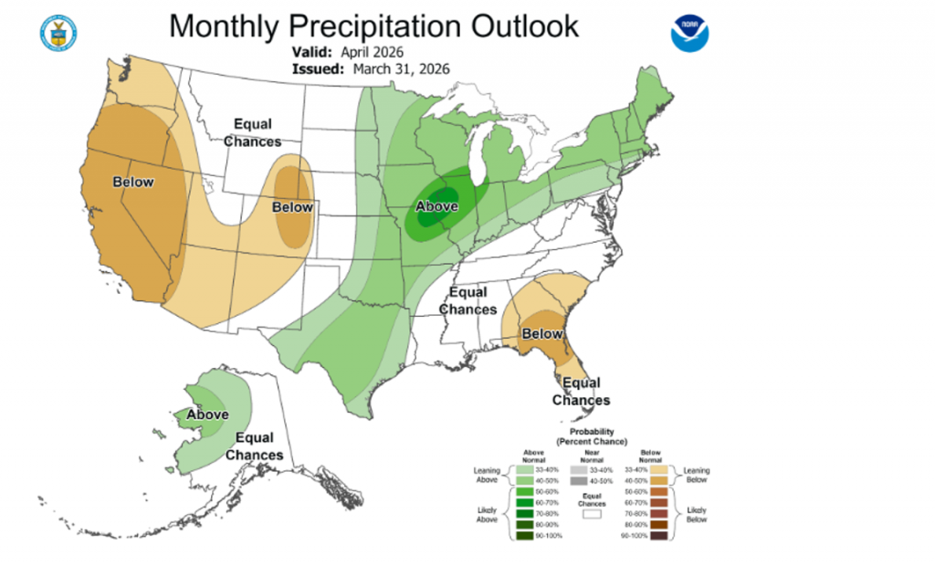
Updated Rainfall Outlook for April
NOAA’s Climate Prediction Center issued a revised outlook for the month of April on Tuesday. The new outlook favors above normal rainfall across most of Texas, extending northeast to the Great Lakes region. Several rounds of rain and storms are forecast through the month.
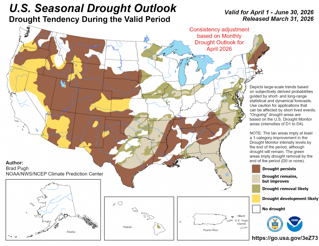
With the forecast leaning toward above normal rainfall across most of the state during April, CPC’s 3-month seasonal drought outlook was revised and now calls for drought improvement across much of the Hill Country and Central Texas.
Have a safe and happy holiday weekend!
Bob
Social Media