Weather conditions remain quiet and fall-like as we close out the workweek. The large bubble of Canadian high pressure which spread into the area following Tuesday’s cold front has brought cooler and considerably drier air to all of Texas. Recent nights have been pleasantly cool while daytime temperatures have still been warm. It’s interesting to note minimum temperatures observed Thursday and Friday mornings have been the coolest since back in April and May. According to LCRA’s Hydromet, low temperatures Friday morning were a mix of upper 40s to mid-50s across much of the Hill Country and Central Texas. Closer to the coast, lows were generally in the upper 50s to low 60s.
Mostly sunny, dry and quiet weather is forecast this afternoon through Sunday as our region remains under a stable ridge of high pressure. Although some scattered high-level clouds may drift over the area from time to time, mostly sunny conditions will prevail. A light southerly breeze will develop this afternoon and continue through Sunday. Low relative humidity levels are forecast this afternoon through Saturday, while slightly higher levels can be expected on Sunday.
- High temperatures this afternoon, Saturday and Sunday are forecast to be near 88-90 degrees.
- Low temperatures Saturday and Sunday mornings are predicted to be near 58-62 degrees.
- Low temperatures Monday morning will range from low 60s across the Hill Country to the upper 60s near the coast.
The weather pattern will begin to change early next week as the ridge of high pressure over Texas weakens. At the same time, a large area of low pressure is forecast to take shape over the Desert Southwest. Forecasts call for the low to remain nearly stationary across the area Monday and Tuesday, followed by a slow track northeast across New Mexico and the Texas Panhandle region next Thursday and Friday. The low pressure area is expected to begin pulling clouds and moisture from the Pacific and the Gulf of Mexico north across Texas Monday, with a good flow of moisture continuing through the end of the week.
As moisture levels increase, there will be a slight chance for a few scattered rain showers and isolated thunderstorms Monday afternoon into Monday night. The chance for showers and thunderstorms looks to increase to around 30 percent Tuesday into Tuesday night. The best chance for rain showers and thunderstorms looks to occur Wednesday into Friday when the low gets closer to Texas. The probability for rain and thunderstorms each day is forecast to be 50-60 percent, followed by a 30 percent chance for rain on Saturday.
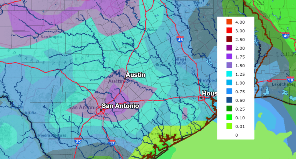
Rain amounts Monday are forecast to average around a tenth of an inch. Rain amounts Tuesday are forecast to be around a quarter inch. Totals Wednesday through Friday are forecast to average between 1 and inches, or possibly more.
The National Weather Service’s 7-day rainfall forecast through 7 pm next Friday calls for widespread rain totals between 1 and 2 inches. And isolated heavier totals will certainly be possible.
NWS Rainfall Forecast for the Period 7 pm Friday through 7 pm next Friday:
High temperatures all of next week are forecast to be near 88-90. Low temperatures are predicted to be close to 70 degrees.
The outlook for next Sunday and the week of October 4th calls for partly cloudy and generally dry weather through the period as a weak ridge of high pressure spreads over Texas. High temperatures are forecast to be around 88-90 degrees, with low temperatures around 66-68 degrees. No big cold fronts are expected.
Tropical Weather Update
Weather conditions are quiet across the Gulf of Mexico and the Caribbean Sea. There are no features in place that pose a threat for development at the current time.
In the central tropical Atlantic, all eyes continue to be on Hurricane Sam. As of 11 am CDT, Sam was centered about 1365 miles northeast of the northern Leeward Islands. Sam was moving just north of due west near 14 mph and this motion is expected to continue through tonight. A decrease in forward speed and a motion toward the west-northwest is expected over the weekend. Maximum sustained winds were at 75 mph with higher gusts. Rapid intensification is forecast to resume over the next several days and Sam is likely to become a major hurricane on Saturday.
Sam is forecast turn to the north-northwest early next week, missing any possible opportunity to move into the Gulf of Mexico.
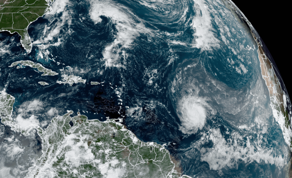
NOAA/Colorado State University/RAMMB 09/24/21 12:40 pm CDT
Elsewhere, the National Hurricane Center is keeping a close watch on an area of disturbed weather located a couple of hundred miles east of Bermuda. There will be a small window for tropical development this afternoon through Saturday. After that, upper-level winds are expected to be too strong to maintain a tropical system.
Forecasters are also monitoring a tropical wave that is expected to move off the west coast of Africa by the end of the weekend. Once over water, environmental conditions are forecast to be favorable for gradual development, and a tropical depression could form over the far eastern Atlantic by the middle of next week, while the system moves westward at 10 to 15 mph. NHC forecasters are giving this system a medium chance, a 40 percent chance, for tropical development over the next 5 days.
Enjoy this first weekend of autumn. The weather should be great!
Bob
Social Media