A line of rain showers and thunderstorms tracked southeast across the eastern Hill Country, Central Texas and the coastal plains regions Sunday night into Monday. Although there was quite a bit of lightning and thunder with the area of rain, no severe storms were reported across South Texas. Rain amounts generally averaged between a quarter and a half inch. Little to no rain was measured across the western or northern Hill Country.
Sunday night’s rain and storms develop along a Pacific cold front that tracked southeast out of West Texas. As of midday Monday, the front stretched from east of Shreveport, to Houston, to Beeville, to just north of Laredo. All of the rain had moved into the Gulf of Mexico and the sky was generally clear. This afternoon’s weather will be sunny, dry and slightly cooler with a high temperature in the low and mid-80s.
Today’s cold front isn’t expected to stick around for very long as forecasts call for the front to lift back north as a warm front Monday night. This will allow warmer and more humid air to return off the Gulf. Under a mostly cloudy sky, lows Tuesday morning will range from the mid-60s across the Hill Country to the low and mid-70s towards the coast. A few spotty light rain showers will be possible late tonight and towards sunrise Tuesday as moisture levels rapidly increase.
Tuesday’s weather will feature morning clouds, followed by a partly cloudy sky in the afternoon. There will be a 30-40 percent chance for scattered rain showers and thunderstorms across the Hill Country and Central Texas regions and just a slight chance for rain across the coastal plains as the atmosphere grows increasingly moist and unstable. Expect a high temperature near 88-90 degrees. Rain amounts Tuesday afternoon are predicted to generally average between a quarter and a half inch.
The focus for rain and thunderstorms this week is expected to occur between Wednesday morning and Thursday evening when a strong trough of low pressure over the Four Corners region lifts up northeast, drawing considerable moisture into Texas out of the Gulf of Mexico and the eastern Pacific. Much of the Hill Country and Central Texas are forecast to be in a favorable zone for the atmospheric lift and moisture convergence. In addition, the upper trough will also push a weak Pacific cold front into West Texas late Tuesday. This front is forecast to stall somewhere over the Hill Country Wednesday into Thursday, providing an extra focus for the development of showers and thunderstorms.
One additional important factor for the development of widespread and significant rain will be the remnants of eastern Pacific Tropical Storm Pamela. As of 1 pm, the center of Pamela was located about 455 miles south-southwest of Mazatlan, Mexico. Pamela is forecast to strengthen into a hurricane tonight and become a major hurricane on Tuesday. National Hurricane Center forecasts call for Pamela to pass south of the southern tip of the Baja California peninsula Tuesday night and make landfall on west-central mainland Mexico Wednesday morning. The circulation center of Pamela is forecast to get pulled northeast across Mexico late Wednesday, and the Edwards Plateau/Hill Country region on Thursday. Although Pamela’s circulation center will be disrupted over the mountains of Mexico, atmospheric lift generated by the system is expected to enhance the development of rain.
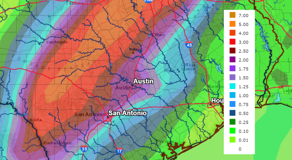
Forecasts call for widespread showers and thunderstorms across the region on Wednesday. Moderate to heavy rain is forecast to develop across the Hill Country and much of Central Texas Wednesday afternoon, with more moderate to heavy rain persisting Wednesday night through Thursday afternoon. Monday’s data shows the heaviest rains will be focused across the western and northern Hill Country—near the path of the remnant center of Pamela. Across this area, totals of 3-5 inches are forecast. It’s not out of the question some areas could see totals as high as 8 or 9 inches. Across the eastern Hill Country and the Interstate 35 corridor (including metro Austin), totals of 1-3 inches are forecast. For areas south and east of La Grange, Gonzales and Brenham, totals through Thursday evening are forecast to average between 0.5 and 1 inch.
NWS Rainfall Forecast for the Period 7 pm Tuesday through 7 pm Sunday:
The chance for rain is predicted to diminish Thursday evening as the area of enhanced moisture pushes off the to the east.
A partly cloudy sky is forecast Thursday night through Friday. Forecasts indicate a strong cold front will sweep south across the area Friday morning through Friday afternoon. A few light rain showers may develop ahead of the front, but rain amounts should total less than a tenth of an inch. High temperatures will range from near 80 degrees across the northern Hill Country to the upper 80s near the coast.
Clear, dry and much cooler weather will follow the cold front Friday afternoon and through the upcoming weekend.
- Lows Saturday morning will include the mid and upper 40s across the Hill Country, the low and mid-50s across Central Texas and the upper 50s towards the coast.
- High temperatures Saturday and Sunday will be in the mid and upper 70s.
- Lows Sunday morning will include the low and mid-40s across the Hill Country, the upper 40s across Central Texas and the low to mid-50s across the coastal plains.
The outlook for next week calls for sunny, dry and mild weather. Expect high temperatures in the low 80s, with low temperatures in the 50s.
Tropical Weather Outlook
Weather conditions across the tropical Atlantic are relatively quiet. National Hurricane Center forecasters are monitoring an area of showers and thunderstorms a couple of hundred miles east of the Windward Islands and another area of disorganized showers and thunderstorms south of the Dominican Republic. Neither system shows much potential for tropical development over the next few days.
In the eastern tropical Pacific, tropical storm Pamela as of 1 pm Monday was located about 455 miles south-southwest of Mazatlan, Mexico. Pamela was moving toward the northwest near 6 mph and this general motion is expected to continue today. A turn toward the north is forecast to occur tonight into Tuesday, followed by a faster northeastward motion by Tuesday night. On the forecast track, Pamela will pass south of the southern tip of the Baja California peninsula Tuesday night or early Wednesday and make landfall on west-central mainland Mexico Wednesday morning. Maximum sustained winds have increased to near 70 mph with higher gusts. Steady to rapid strengthening is forecast, and Pamela is expected to become a hurricane by tonight and a major hurricane on Tuesday. Pamela is forecast remain a major hurricane until it reaches the coast of Mexico on Wednesday.

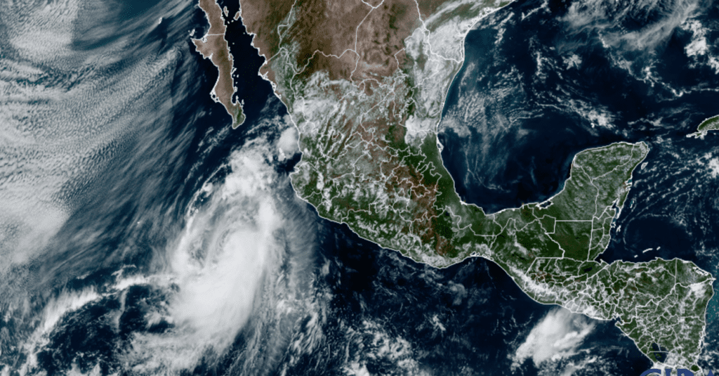
NOAA/Colorado State University/RAMMB 10/11/21 2:20 pm CDT
Bob
Social Media