Friday started off rather chilly, with the temperature falling to the 30s across the Hill Country and most of Central Texas. In fact, according to LCRA’s Hydromet, readings fell below freezing at several locations across the western and northern Hill Country. The lowest recorded temperature was a cold 27 degrees, at a gauge along the South Llano River, about 5 miles southwest of Telegraph.
A dry and very quiet weather pattern continues across Central and South Texas as we close out the workweek. Sunny, dry and stable conditions are expected to continue through weekend as our region remains under the influence of a weak ridge of high pressure in the upper atmosphere. Thursday’s cold front brought in a blast of very dry and somewhat cooler air. Strong northwesterly breezes of 10-20 mph look to continue this afternoon. This will be followed by lighter winds of 5-10 mph Friday night. But brisk southerly breezes of 10-20 mph with gusts to 30/35 mph are predicted to develop Saturday and continue through Sunday. The combination of strong winds and dry air is expected to create elevated to near critical fire weather conditions across the region Saturday. As a result, the National Weather Service has posted a Fire Weather Watch for all of Central Texas and the Hill Country Saturday. Although slightly higher relative humidity levels are expected Sunday, a high fire danger will continue.
- Lows Saturday morning will range from the low 40s across the Hill Country, to the upper 40s near the coast.
- Low temperatures Sunday morning will generally be in the upper 50s to low 60s.
- Low temperatures Monday morning are predicted to be in the mid and upper 60s.
- High temperatures Saturday and Sunday are forecast to be in the mid and upper 80s. Some Hill Country locations may get close to 90 degrees Sunday.
Our weather is predicted to become a bit more active the first half of next week as the ridge of Texas weakens and a trough of low pressure develops across the western U.S. This trough is forecast to track to the east, dragging a cold front to the east and causing a chance for rain showers and thunderstorms.
For Monday, clouds and moisture are forecast to increase off the Gulf of Mexico. Expect a partly to mostly cloudy sky with breezy conditions. High temperatures will be in the mid and upper 80s. There will be a slight chance for a couple of isolated thunderstorms along the Interstate 35 corridor Monday evening as the dry line moves in from the west. However, a strong cap in the middle atmosphere is expected to limit most thunderstorm development.
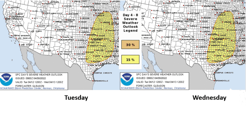
A better chance for rain showers and scattered thunderstorms is expected to develop Tuesday through Wednesday. On Tuesday, a weak wave of low pressure is predicted to track east out of Mexico and is expected to cause the development of scattered thunderstorms beginning late morning across the Hill Country in the vicinity of the dry line. The scattered showers and thunderstorms are forecast to spread east across the eastern Hill Country, Central Texas and coastal regions Tuesday afternoon through Tuesday evening. Some of the thunderstorms may be strong to severe over parts of the eastern Hill Country and the northern counties of Central Texas, including metro Austin. Severe weather threats will include large hail, damaging winds and isolated tornadoes. Rain amounts Tuesday are forecast to generally average between a quarter and a third of an inch. High temperatures Tuesday are forecast to be near 88-90 degrees.
There will be another chance for rain and thunderstorms Wednesday afternoon into Wednesday evening when a cold front is forecast to track southeast out of Northwest Texas. An area of showers and thunderstorms is forecast to develop ahead of and along the cold front, with some of the storms possibly becoming severe. Once again, the eastern Hill Country and the northern counties of Central Texas, including metro Austin will be the areas with the greatest threat for severe storms. Large hail and damaging winds look to be the primary severe weather threats. Rain amounts are predicted to again average between a quarter and a third of an inch. High temperatures Wednesday are forecast to be near 88-90 degrees.
The chance for rain should end from west to east late Wednesday as drier and slightly cooler air spreads in behind the cold front.
The Storm Prediction Center’s Severe Weather Outlook for Tuesday and Wednesday:
Sunny, dry and cooler is expected next Thursday and Friday in the wake of Thursday’s cold front. High temperatures both days are forecast to be in the upper 70s. Lows Friday and Saturday mornings are predicted to be in the low 50s.
Forecasts call for a slight chance for rain to develop next Saturday when a trough of low pressure and cold front push east across the state. Rain amounts are expected to be low—generally around a tenth of an inch. Aside from this slight chance for rain, next weekend’s weather is shaping up to be mostly sunny and mild. Expect highs in the upper 70s, with lows in the 50s.
Looking out into the week of April 18th, long-range forecasts are calling for a generally dry pattern with mild temperatures. Expect highs in the upper 70s to low 80s, with lows in the 50s.
Two Years to the 2024 American Total Solar Eclipse!
If you’ve witnessed a total eclipse of the Sun, you already know that when the next one rolls around on April 8, 2024, North America will be in for a real treat. That’s when the Moon will blot out our nearest star for lucky viewers along a narrow strip of land that stretches from central Mexico, across Texas, up through New England, and into the Canadian Maritimes. Tens of millions more will see a partial eclipse, provided skies are clear.
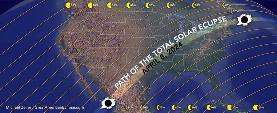
Great news! The path of totality will be over the Hill Country, just to the west of Austin and San Antonio. It might be two years away, but it’s never too early to start planning. You’ll want to think carefully of where you want to be on the path of totality, how to get there, and also how to get out of there. You’ve got two years to make your plans.
Have a great weekend.
Bob
Social Media