Although autumn begins Thursday, it appears summer will not be giving up without providing our region one last spell of July/August like temperatures. A strengthening ridge of high pressure, or heat dome, over the southern Plains states this week is expected to spike high temperatures close to, or in some cases up to 100 degrees.
Monday’s weather maps showed the heat dome was already taking shape across Texas and the southern Plains states, with the center currently located over eastern Oklahoma and western Arkansas. Forecasts call for the heat dome to remain over this same general area through the end of the week, with the ridge predicted to reach its greatest intensity Wednesday through Friday. The ridge will cause a pattern of dry, hot and stable weather throughout the week and into the upcoming weekend.
This afternoon, an area of lingering moisture along the middle and upper Texas coast will cause a 30 percent chance for scattered rain showers and isolated thunderstorms. Spotty totals to around a quarter inch will be possible. The chance for rain across the coastal region will diminish Tuesday as the atmosphere dries out and becomes increasingly more stable. Meanwhile, the Hill Country and Central Texas regions look to remain rain-free this afternoon and throughout the week.
- High temperatures today and Tuesday are forecast to be in the upper 90s across Central Texas, and in the low to mid-90s across the Hill Country and coastal regions.
- High temperatures Wednesday through Friday are forecast to be near 98-100 degrees across Central Texas, and in the mid to upper 90s across the Hill Country and coastal regions.
- Low temperatures throughout the week will range from 70 degrees across the Hill Country, the mid-70s across the coastal plains.
The temperature is forecast to trend slightly lower this weekend as the ridge of high pressure over Texas begins to weaken. Expect a sunny sky both days.
- High temperatures Saturday will include the upper 90s across Central Texas, and mid-90s at most other locations
- High temperatures Sunday are forecast to be in the mid-90s across Central Texas, with lower 90s forecast for most other locations.
Small changes in the weather are predicted to take place next Monday when trough of low pressure tracking east across the Plains helps push a weak cold front south through Texas. The front is predicted to push off the middle Texas coast Monday afternoon. An area of light rain showers and isolated thunderstorms is predicted to accompany the cold front Monday morning as it moves to the south. Unfortunately, widespread rains are not expected due to the lack of significant moisture. Most rain amounts are forecast to average less than a quarter inch.
Dry and slightly cooler air is expected to follow the cold front beginning Monday afternoon, continuing through late week. Next week’s high temperatures are forecast to be in the low to mid-90s across Central Texas, with lower 90s expected at most other locations. Low temperatures are forecast to be in the mid and upper 60s.
Weather conditions are forecast to remain dry late next week into the following weekend as our region remains under the influence of a weak ridge of high pressure in the upper atmosphere.
Tropical Weather Update
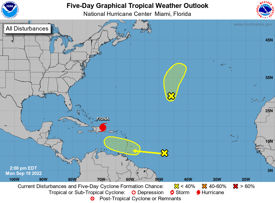
National Hurricane Center forecasters are monitoring a tropical wave located over the central tropical Atlantic, several hundred miles east of the Windward Islands. This system is currently producing an area of disorganized showers and thunderstorms. Some gradual development of this system is possible during the next several days while the system approaches the Windward Islands toward the end of the week and moves over the eastern Caribbean sea over the weekend. NHC forecasters are giving this system a 20 percent chance for tropical development over the next 5 days.
Fiona strengthened into a hurricane over the weekend and tracked across the southwestern coast of Puerto Rico on Sunday. The hurricane brought catastrophic flooding to much of Puerto Rico, which is still ongoing. As of early Monday afternoon, Hurricane Fiona was located about 165 miles southeast of Grand Turk Island. Maximum sustained winds are near 85 mph with higher gusts. Strengthening is expected during the next few days, and
Fiona is forecast to become a major hurricane by Wednesday. Fiona is moving toward the northwest near 9 mph. This general motion is expected to continue through tonight, followed by a turn toward the north-northwest on Tuesday and to the north on Wednesday. Based on the forecast track, the center of Fiona will pass near or to the east of the Turks and Caicos on Tuesday. Looking out longer-term, Fiona is forecast to turn to the north Wednesday, and to the northeast Thursday into Friday. On this track, Fiona is forecast to pass very close to Bermuda on Friday, then accelerated northeast to Newfoundland Saturday.
Forecasters are also monitoring an area of low pressure located over the central subtropical Atlantic. Some slow development of this system will be possible over the next couple of days before less favorable late this week. This system poses no threat to the Caribbean Sea or Gulf of Mexico.
Autumn Arrives Thursday Evening
The autumnal equinox—also called the September equinox or fall equinox—arrives this Thursday, September 22 at 8:04 pm CDT. This date marks the start of fall in the Northern Hemisphere and spring in the Southern Hemisphere. During the equinox, the Sun crosses what we call the “celestial equator”—an imaginary extension of Earth’s equator line into space. The equinox occurs precisely when the Sun’s center passes through this line. On the day of the equinox, day nights are roughly 12 hours long all across the globe. After the autumnal equinox, days become shorter than nights across the Northern Hemisphere as the Sun continues to rise later and nightfall arrives earlier. This ends with the winter solstice, after which days will start to grow longer once again.
Bob
Social Media