Quiet and Pleasant this Weekend. Cooler Temperatures Arriving Late Next Week
March 3, 2023
The first big storm system of spring came through with quite a bang Thursday night! While the storms produced large hail at a few isolated locations, the biggest impact by far was the strong and gusty wind. Peak wind from the storms and also from gradient winds developing behind the storms produced widespread gusts of 50-60 mph across the Hill Country and the Interstate 35 corridor. In Austin, Camp Mabry recorded a peak gust of 54 mph, while Austin-Bergstrom’s peak gust was 58 mph. To the southeast of Austin, top winds were a little lower—generally between 40 and 50 mph.
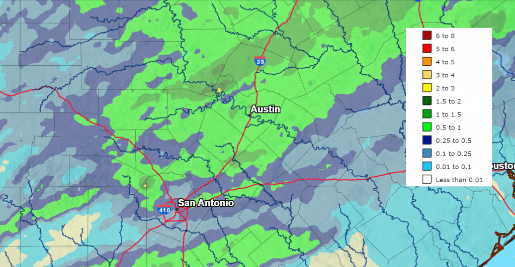
The storms Thursday morning and Thursday evening did produce some nice totals of rain across a small part of the Hill Country. According to LCRA’s Hydromet and Doppler radar estimates, totals of 1-1.5 inches were recorded over the area between Fredericksburg, Marble Falls, and Florence. The big winner was an LCRA gauge located near Lago Vista, in Travis County, where the rain totaled 2.17 inches. Totals across the eastern half of the Hill Country and most of Central Texas were generally between 0.5 and 1 inch. Meanwhile, totals across the western Hill Country and the coastal plains were less than two-tenths of an inch.
NWS Estimate of Rain Falling Between 9 am Wednesday and 9 am Friday:
The storm system responsible for Thursday’s active weather has exited Texas and moved east to the Tennessee Valley region. In its wake, a dry and stable weather pattern has set up across Texas and the south central U.S. This dry and stable pattern is forecast to continue through the weekend and early next week. The next significant change in the weather is expected to take place the middle of next week when a fairly strong Canadian cold front pushes south through the area, bringing significantly cooler air and a chance for rain.
Friday Afternoon and Friday Night
Breezy conditions will continue across the area through Friday afternoon. However, wind speeds are forecast to decrease significantly late Friday afternoon into Friday evening as the pressure gradient weakens. Expect wind speeds of 5-10 mph Friday night. High temperatures Friday are predicted to be near 70-72 degrees. Lows Saturday morning will include the mid-40s across the Hill Country, and mid to upper 40s at most other locations.
Saturday through Sunday
Weekend weather conditions are shaping up to be sunny and very spring-like. High temperatures both days are predicted to be close to 80 degrees. Lows Sunday morning will be in the upper 40s to low 50s. Lows Monday morning will be in the mid and upper 50s, with low 60s expected towards the coast.
Monday through Tuesday
Warmer and more humid weather is forecast both days. Expect a pattern of late night and morning clouds, followed by sunny conditions in the afternoon. High temperatures both days are predicted to be in the mid-80s. Low temperatures are predicted to be in the low 60s, with mid and upper 60s expected across the coastal plains.
Next Wednesday and Thursday
A large trough pushing east across the Plains states will help push a Canadian cold front south into Texas. The front is forecast to reach the northern Hill Country sometime late Tuesday night, then move across Central Texas and the middle Texas coast on Wednesday. Forecasts call for a chance for rain showers to develop with the cold front Wednesday, followed by periods of light showers Wednesday night through Thursday night. Rain amounts are not expected to be very heavy, with most totals averaging less than a quarter inch.
Noticeably cooler temperatures are expected behind the cold front.
- High temperatures Wednesday are predicted to be in the 70s.
- Lows Thursday morning are predicted to be in the upper 40s to mid-50s.
- High temperatures Thursday are predicted to be in the 50s.
- Low temperatures Friday morning are forecast to generally be in the 40s, with upper 30s expected across the Hill Country.
Next Friday and Next Weekend
Most sunny, dry weather is forecast. However, temperatures will be somewhat cool. Expect high temperatures in the 60s, with lows mostly in the 40s. Readings in the upper 30s will be possible across the Hill Country and parts of Central Texas.
The Venus and Jupiter Sky Show Continues
Venus and Jupiter continue to shine together in the western sky at dusk. Venus is the brightest of the two planets. Venus is now the upper planet, having traded places with Jupiter at their March 1st conjunction.
The two are getting farther apart every day. On Friday March 3rd, they’re separated by 2°. However, a week from now, the two will be 9° apart.
Time Change Coming Up NEXT Weekend
Just a reminder: the switch to Daylight Saving Time will occur next Sunday, March 12th. The week coming up will be the last week of Standard Time.
Have a good weekend!
Bob
Social Media