A Chance For Rain Developing Thursday, Continuing through the Weekend
May 1, 2023
Welcome to the month of May! May is typically the wettest and stormiest month of the year for Central Texas, and there are some early signs May 2023 might live up to that reputation.
Quiet weather will be in place for the first half of this week, but the weather pattern is predicted to turn more unsettled Thursday when a series of small low pressure troughs begin moving across Texas out of Mexico. Periods of rain showers and scattered thunderstorms are forecast to continue across the region between Thursday and Sunday. Heavy rain is not expected. Forecasts for next week show an other period of rain and thunderstorms developing sometime between Wednesday and Friday. This period of rain has the potential to cause somewhat higher totals of rain.
Warm temperatures are forecast over the next ten days, but no unusually warm weather is expected.
Here’s a breakdown of this week’s weather:
This Afternoon through Tonight
A sunny sky is forecast this afternoon as scattered high clouds spread over the region out of the west. High temperatures will generally be in the mid-80s. Expect a light southeasterly breeze at 5-10 mph.
Low clouds are predicted to slowly increase late this evening as moisture starts to return off the Gulf of Mexico. Parts of Central Texas and the coastal plains could see some patchy fog develop late Monday night into Tuesday morning. Lows Tuesday will be in the low 60s.
Tuesday through Wednesday Night
Morning clouds and patchy fog will give way to a partly cloudy sky Tuesday afternoon. It will begin to feel more humid as Gulf air returns in earnest behind a retreating warm front. Tuesday’s temperature is forecast to reach the low and mid-80s.
Widespread low clouds and patchy fog will redevelop late Tuesday night and continue through late morning Wednesday. Lows Wednesday morning are forecast to be around 60-62 degrees. Expect a mostly sunny sky Wednesday afternoon with high temperatures in the mid-80s.
Low clouds are forecast to return Wednesday night. Lows Thursday morning are predicted to be in the mid-60s.
Thursday through Sunday
Forecasts call for a series of weak low pressure troughs to begin pushing across Texas out of Mexico starting on Thursday. Moisture levels are forecast to increase, enhancing to the chance for rain and also keeping overnight temperatures quite mild.
Thursday’s weather will include an increased chance for scattered thunderstorms to spread across the Hill Country out of West Texas late Thursday afternoon into Thursday evening. The probability for rain will be near 30 percent. Elsewhere, just a slight chance (a 20 percent chance) for scattered rain showers and isolated thunderstorms is forecast. Expect a party to mostly cloudy sky. Thursday’s temperature is forecast to warm to the mid-80s. Meanwhile, lows Friday morning are forecast to be around 70 degrees.
Friday through Sunday, there will be a 30 percent chance for scattered rain showers and thunderstorms mainly across the Hill Country and Central Texas regions as several troughs of low pressure move overhead. Expect a partly to mostly cloudy sky each day. Daily high temperatures are forecast to be around 88-91 degrees. Low temperatures are forecast to be around 70 degrees.
Daily rain amounts are forecast to average close to a quarter inch.
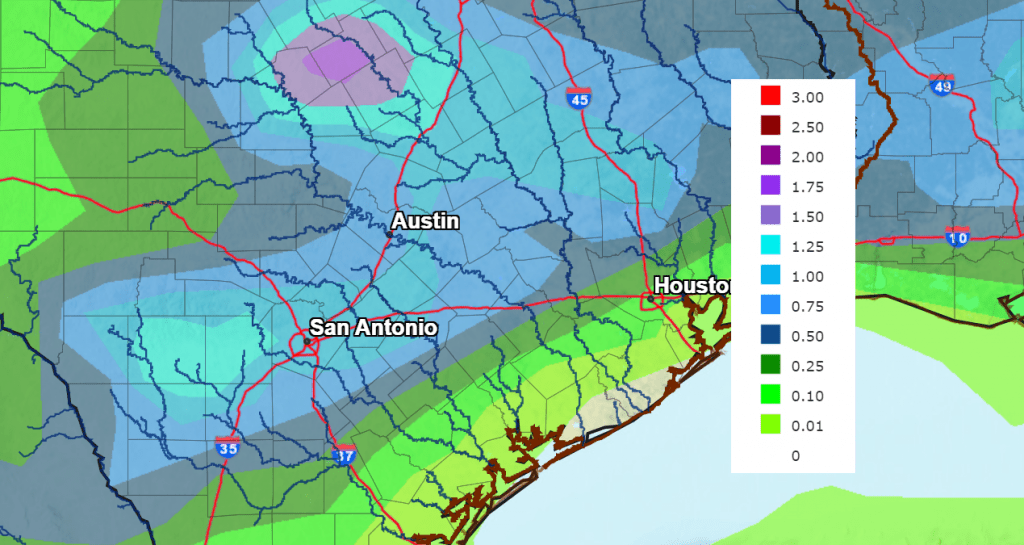
The National Weather Service’s rainfall cumulative forecast through Sunday calls for widespread totals of 0.5 to 1 inch across the Hill Country and Central Texas regions, along with some isolated heavier totals. Totals across the coastal plains are forecast to predicted to be below a quarter inch.
NWS Rainfall Forecast for the Period 7 pm Monday through 7 pm Next Monday:
Next Week
A temporary break in the wet pattern is forecast next Monday and Tuesday. Forecasts point toward an increasing chance for rain and thunderstorms across the region next Wednesday and Thursday as a large trough of low pressure tracks to the east out of Mexico.
High temperatures next week are forecast to be in the mid and upper 80s. Low temperatures are predicted to be in the mid and upper 60s.
May Day is May 1
You might not realize it, but May Day – an ancient spring festival in the Northern Hemisphere – is an astronomy holiday. It’s one of the year’s four “cross-quarter” days. That is, it’s a day that falls more or less midway between an equinox and solstice. In this case, it’s between the March equinox and June solstice. We’re half way through spring and just 6 weeks until the start of astronomical summer!
Bob
Social Media