A Chance for Thunderstorms Tuesday and Tuesday Night. Hot Weather Going into the Weekend
June 2, 2025
We’re looking at a warmer and less active weather pattern this week as our region begins to feel the influence from a heat dome over northwestern Mexico. Much of the area will see a chance for thunderstorms Tuesday night into Wednesday morning. Otherwise, the pattern is looking to stay dry through the upcoming weekend and into early next week.
Monday’s weather is expected to be mostly sunny and hot as a ridge of high pressure spreads over Texas out of Mexico. High temperatures are forecast to be in the mid-90s. Lows Tuesday morning are predicted to be mostly in the mid-70s.
A change in the weather pattern is forecast to take place Tuesday into Wednesday when the ridge of high pressure over Texas weakens, allowing a trough of low pressure to lift northeast from New Mexico into the southern Plains states. Scattered thunderstorms are forecast to develop across West and Far West Texas Monday evening in response to the approaching trough. Some of these thunderstorms are predicted to spread as far east as the western and northern Hill Country late Monday night and toward daybreak Tuesday. The threat for any of these storms to be severe will be quite low. This particular area of storms is forecast to diminish around daybreak Tuesday.
A second and somewhat better chance for showers and thunderstorms is forecast to take place across the western and northern Hill Country Tuesday afternoon as another area of thunderstorms blossoms across West Texas in response to the approaching trough over New Mexico. These storms are predicted to spread east across the Hill Country and into Central Texas Tuesday afternoon into Tuesday night, reaching the coastal plains region Wednesday morning. The probability for rain Tuesday afternoon through Wednesday morning will be at 40-50 percent.
Some of the storms Tuesday afternoon and evening may be strong to severe across the Hill Country. The Storm Prediction Center has placed most of North Texas, extending south to Burnet, Mason, and Eldorado under a Slight Risk, or a 2 out of 5 risk for severe storms through 7 am Wednesday. A Marginal Risk, or a 1 out of 5 risk, for severe storms extends as far south as Austin, Kerrville, and Rocksprings.

The primary severe weather threats will be large hail and damaging winds, with a tertiary tornado threat. The rain and thunderstorms are predicted to evolve into clusters of storms that will spread to the south along a weak cold front. The front is forecast to reach the coastal plains region Wednesday morning. The chance for rain and storms should end from northwest to southeast as drier and slightly cooler air spreads in behind the cold front.
Rain amounts through Wednesday are forecast to be highest across the northern Hill Country, and lowest towards the coast. Totals will range from 0.5 to 1 inch across the north, to less than a quarter inch for locations south of Interstate 10.
NWS Rainfall Forecast Valid through 7 pm Wednesday:
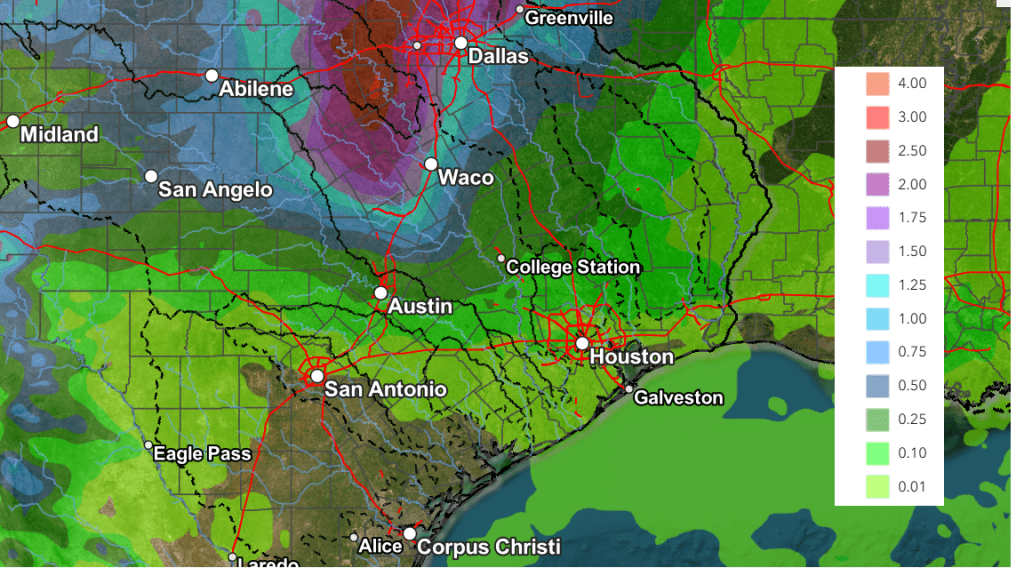
The temperature is forecast to trend a bit lower Wednesday in the wake of the cold front. Afternoon high temperatures will range from the mid-80s across the northern Hill Country, to the low 90s across the coastal plains. The cold front’s visit will be brief as it is predicted to lift back to the north late Wednesday night.
Mostly sunny, dry, and hot weather is forecast Thursday and through the weekend as a ridge of high pressure centered over Mexico spreads east to cover Texas.
- High temperatures Thursday are forecast to be in the low and mid-90s
- High temperatures Friday are predicted to be in the mid and upper 90s
- High temperatures Saturday through Monday are forecast to be near 100 degrees across the Hill Country and Central Texas regions, and in the mid-90s across the coastal plains
Looking ahead to next week, the forecast solutions call for the ridge of high pressure to shift slightly to the west, which should help cause high temperatures to lower slightly to the mid and upper 90s. There are indications we could see a chance for rain develop around the middle of next week.
Tropical Weather Outlook
National Hurricane Center forecasters are monitoring the area offshore of the southeastern U.S. Coast where a non-tropical area of low pressure is forecast to form near or just offshore of the coast during the next couple of days. If the system remains offshore, the low could gradually develop some subtropical or tropical characteristics later this week while moving northeastward at 10 to 15 mph.
NHC is giving this system a low chance, just a 10 percent chance for tropical development over the next seven days.
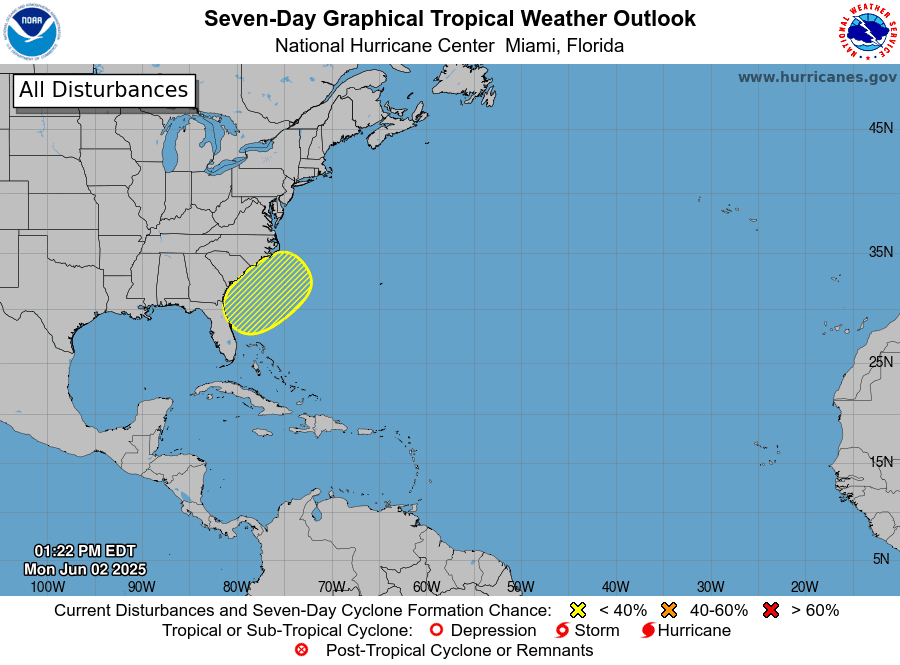
Elsewhere, weather conditions are quiet and tropical cyclone development is not expected over the next seven days.
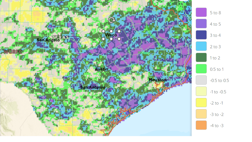
May Rainfall Was Above Normal Across Most of Region
The month of May concluded with rain totals above normal at most locations. Some of the highest totals for the month occurred around Lake Buchanan, where an LCRA gauge on the northeast side of the lake recorded 10.5 inches. A gauge located in western Fayette County recorded a monthly total of 9.34 inches. The area receiving the least amount of rain was across the western Hill Country between Eldorado and Sonora, extending east to near Harper, where monthly totals only averaged between 1 and 2 inches.
May Rainfall Departure from Normal (Courtesy National Weather Service)
Have a good week!
Bob
Social Media