Scattered Rain Showers and Thunderstorms Forecast through the Weekend
AUG. 1, 2025
After several days of hot, rain-free weather, a chance for rain has returned to the forecast for Friday, the weekend, and early next week. The highest probability for rain and thunderstorms looks to occur Saturday, with lower chances following Sunday and Monday. Despite the chance for rain this weekend, hot temperatures look to continue, although not as hot as was observed Thursday.
Friday’s weather maps showed much of Texas was situated within a break between two ridges or high pressure, or heat domes. The first ridge was centered over Far West Texas, northern Mexico, and the Desert Southwest, while the second ridge covered most of the Gulf of Mexico and the southeastern U.S. Forecasts call for this break between the two ridges to shift further west into Texas late Friday and through the weekend. This “break zone” will allow tropical moisture to spread inland to Central Texas and the Hill Country and will be the source for the development of scattered afternoon showers and thunderstorms.
Meanwhile, forecasters are also monitoring the progress of a rare summer cold front that currently stretches east-west across North Texas. As of late Friday morning, the front stretched from San Angelo, to Waco, to Shreveport. The front is forecast to sink a little further to south Friday afternoon, then pull up stationary over the Hill Country and Central Texas on Saturday. The combination of the stalled front, a weaker ridge, and increased tropical moisture will cause a chance for scattered rain showers and thunderstorms across the region Friday afternoon through Monday afternoon.
- Friday afternoon into Friday evening, the probability for scattered rain and thunderstorms is forecast to be near 30 percent across the northern half of the Hill Country and Central Texas (including the Austin metro), and the middle Texas coast
- Saturday afternoon into Saturday evening, the probability for scattered rain and thunderstorms will be near 40-50 percent across the entire region
- For Sunday and Monday, the probability for scattered rain and thunderstorms looks to diminish across most of the Hill Country, while a 20-30 percent chance for rain and thunderstorms will continue for Central Texas and the middle Texas coast
Developing scattered showers and thunderstorms Friday through Monday are expected to move slow-movers and will have the potential to produce locally heavy downpours at a few locations. In general, daily rain amounts are forecast to average between a quarter and a half inch, with isolated totals of 1-2 inches.
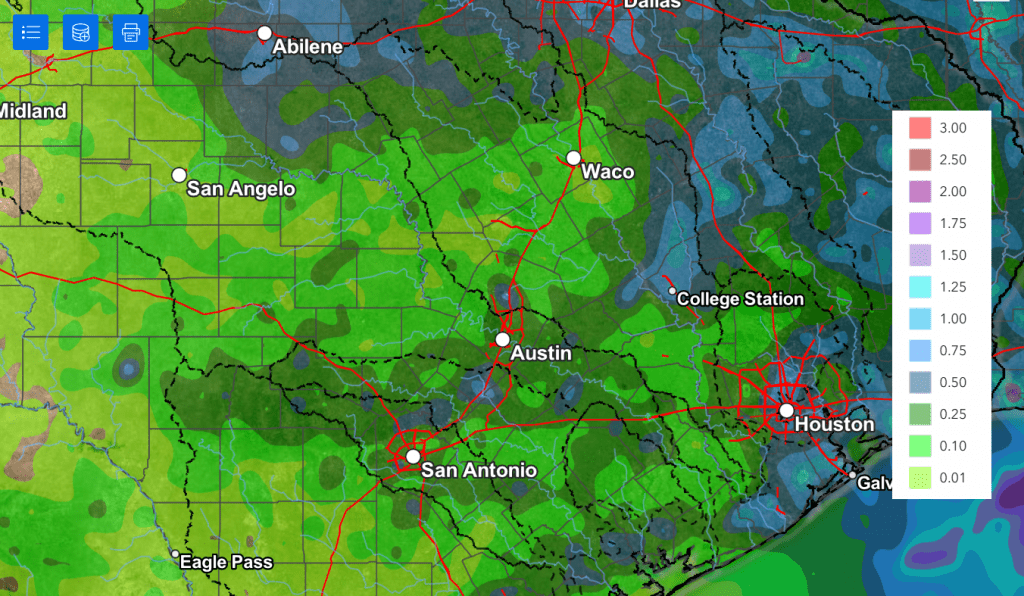
The National Weather Service’s rainfall forecast through Monday evening only shows cumulative totals of 0.25 to 0.5 inches. However, I do think believe totals will be a bit higher than what is shown.
NWS Rainfall Forecast Valid through 7 pm Monday:
- High temperatures Friday are forecast to be near 98-100 degrees at most locations
- High temperatures Saturday through Monday are predicted to be in the upper 90s
Mostly sunny, hot, and rain-free weather is predicted next Tuesday through Friday and next weekend. Forecasts call for the western ridge of high pressure located over northern Mexico and the Desert Southwest to expand east to cover all of Texas. Fortunately for us, the center of the ridge is predicted to remain over New Mexico and not directly over Texas. This should keep the hottest temperatures more out to the west.
- High temperatures Tuesday through next Sunday are forecast to be in the upper 90s to 100 degrees across the Hill Country and Central Texas regions, and in the mid to upper 90s across the coastal region
Looking out into the week of August 11th, little change is forecast. High temperatures are forecast to remain mostly in the upper 90s to 100 degrees.
Tropical Weather Outlook
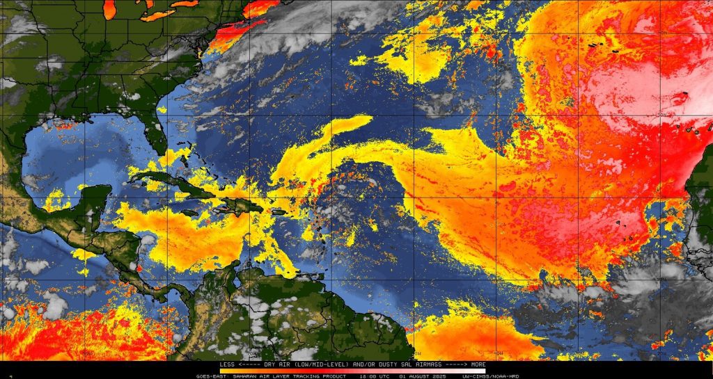
Weather conditions are currently quiet across the tropical Atlantic and are expected to remain that way over the next week.
Friday’s satellite images showed a large area of Saharan dust (shown in the yellow and red colors) stretching from the Caribbean Sea to the west coast of Africa. A tropical wave can be seen just east of the Lesser Antilles, but it is surrounded by dry air and Saharan dust, creating unfavorable conditions for tropical development.
July Climate
The month of July ended with the temperature averaging between 1 and 2 degrees below normal across Central Texas and the middle Texas coast, and between 2 and 4 degrees below normal across the Hill Country.
Of course, unusually heavy and flooding rains were the big story for the month. Totals generally averaged between 6 and 12 inches above normal across most of the Hill Country. According to the Texas State Climatologist’s Office, for the Edwards Plateau climate division, the current July rain estimate for the area averages somewhere between 7.4″ and 7.7 inches. The previous wettest July on record occurred in 1976, with an area average of 7.12 inches. Among all months of the year for the Edwards Plateau, July’s estimate of 7.4 to 7.7 inches should place it somewhere between the 6th and 14th wettest month ever recorded. The final numbers from NCEI will be released on August 8th.
It’s interesting to note July rainfall averaged between 1 and 2 inches below normal across the middle and upper Texas coast.
Have a great weekend!
Bob
Social Media