A Slight Chance for Showers is Forecast the First Half of this Week
AUG. 11, 2025
Very typical, August weather will continue across this region this week. There will be a slight chance to a chance for scattered afternoon and evening rain showers and isolated thunderstorms across the entire region Monday, Tuesday, and Wednesday as a weak trough of low pressure slowly lifts to the north-northwest and a weak cold front stalls over the Concho Valley. The probability for rain will be near 20-30 percent across the Hill Country and Central Texas regions, and near 40 percent across the coastal plains. For areas that happen to catch a shower or thunderstorm, rain amounts will average around a quarter inch, with isolated totals to near 1 inch possible.
- High temperatures each day are predicted to be in the mid and upper 90s
Late week and through the upcoming weekend, the chance for scattered showers is forecast to diminish across the Hill Country and Central Texas regions as a ridge of high pressure begins to spread over Texas from the Gulf. Meanwhile, a few scattered afternoon showers and thunderstorms will continue across the coastal Plains region along the sea breeze front. Expect a mostly sunny sky and hot temperatures.
- Daily readings are forecast to reach the upper 90s to 100 degrees across the Hill Country and Central Texas regions, and into the mid-90s across the coastal region
The outlook for next week shows little change as Texas will remain under the influence of a large ridge of high pressure centered over northern New Mexico. We’ll be keeping a close eye on the progress of what is currently Tropical Storm Erin. Forecast show little change in the temperature, with highs staying around 98-100 degrees. There are some indications high temperatures may trend down 2-3 degrees beginning late next week as a trough of low pressure develops south into the Ohio and Tennessee Valleys.
Tropical Weather Outlook
Tropical Strom Erin
The strong tropical wave which pushed off the west coast of Africa and moved across the Cabo Verde Islands Sunday maintained a small, but persistent area of deep convection into Monday morning. This convection appeared to be sufficiently organized and contain winds in excess of 39 knots for the National Hurricane Center to declare the system as a tropical storm and given the name Erin.
As of 10 am CDT, the center of Tropical Storm Erin was centered in the eastern tropical Atlantic, about 280 miles west-northwest of the Cabo Verde Island. Erin was moving toward the west near 20 mph this motion is expected to continue for the next several days. Earlier satellite wind data indicated that maximum sustained winds were near 45 mph with higher gusts.
Erin is currently over waters whose temperature is only near normal for August. Environmental conditions are forecast to become increasingly favorable for development as the system moves westward into warmer waters under weak wind shear conditions over the next few days. Most of the intensity guidance brings Erin to a hurricane in 48-72 hours, with the official NHC forecast to 80mph in 60 hours and 115mph (a major hurricane) at day 5. It appears that Erin will be an increasingly large and powerful hurricane over the southwest Atlantic by this weekend.
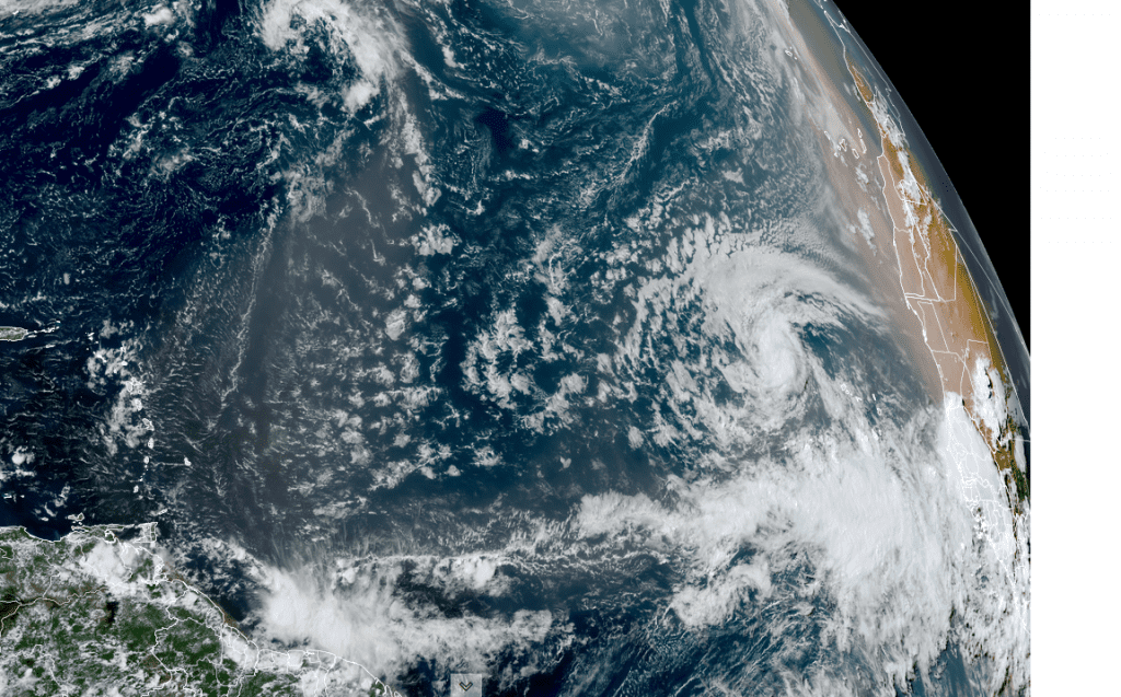
NOAA/Colorado State University/RAMMB 08/11/25 1:20 pm CDT
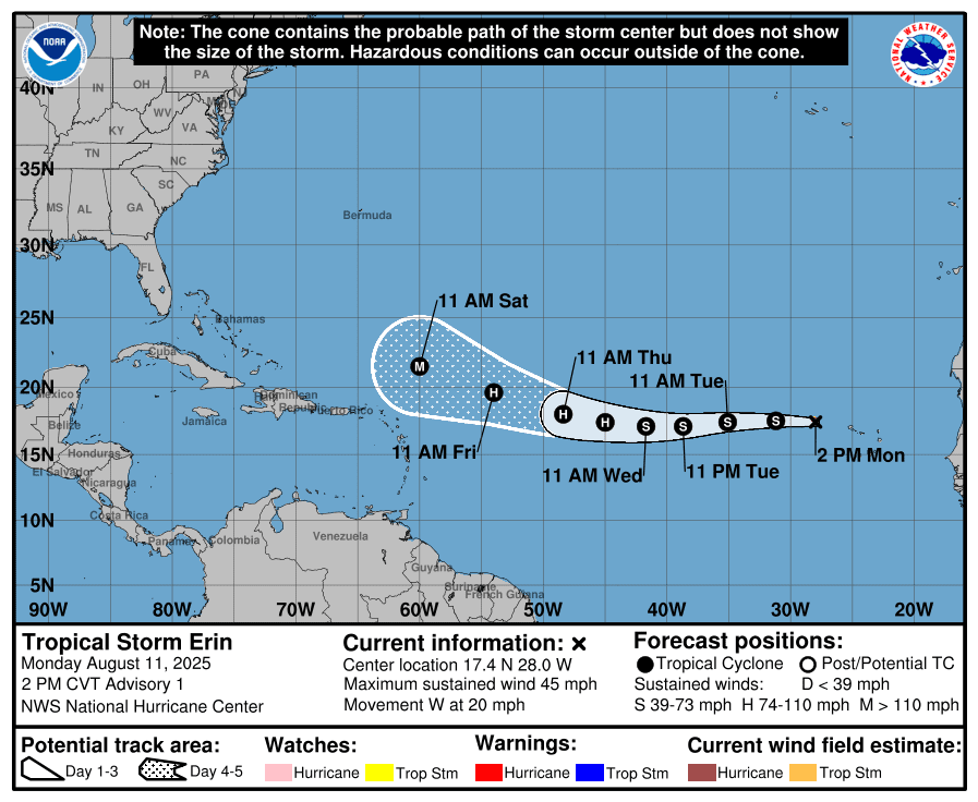
It’s too early to know confidently where Erin will eventually track. Most of the computer-forecast solutions suggest Erin’s path will turn northwest once it gets north of the Lesser Antilles. However, a path further to the west cannot be completely ruled out. Stay tuned for additional updates this week.
National Hurricane Center forecasters are also monitoring a broad area of disorganized showers located over the northeastern Gulf associated with a weak surface trough of low pressure. While development of this system is not anticipated before it moves inland, locally heavy rainfall could produce flash-flooding along portions of the Florida Panhandle over the next day or so. NHC forecasters are giving this system a zero chance for tropical development over the next seven days.
The Perseid Meteor Shower is this Week
The Perseid meteor shower hits its peak the mornings of Aug. 12 and 13, bringing with it a torrent of shooting stars along with the potential for spectacular fireball sightings. The Perseids are one of the most highly anticipated shooting star displays of the year. However, the 2025 shower happens to coincide with the rise of a waning gibbous moon, the glare from which will make it a challenge to spot all but the brightest of meteors.
Still, it’s worth heading out to a dark sky location for a meteor hunt, especially in light of the Perseids’ reputation for spawning impressive fireballs! The best time to spot Perseids will be in the predawn hours of Aug. 13, when up to 100 shooting stars per hour would be visible under ideal conditions, though many will be hidden this year in the glare of the 86%-lit waning gibbous moon. (Space.com)
Bob
This report was posted Monday afternoon, 08/11. For the most up to date weather information, please consult the National Weather Service:
Social Media