Periods of Rain and Thunderstorms Expected this Weekend. Not Quite as Hot Next Week
SEPT. 5, 2025
Another mostly sunny and very hot day is in store for Central and South Texas Friday as the center of a high pressure ridge remains parked over Central Texas. Readings will likely be a couple of degrees lower than what was observed Thursday, due to an area of high-level clouds that will be spreading in from the west.
- High temperatures Friday are predicted to be near 98-101 degrees across the Hill Country and Central Texas regions, and middle 90s across the coastal plains
The weather pattern will begin to change Saturday when a developing trough of low pressure across the Midwest will help to push a weak cold front south through Texas. As of late Friday morning, the front had already reached the northern Texas Panhandle and central Oklahoma. Forecasts call for the cold front to move into North Texas Friday evening, reaching the Hill Country be about sunrise Saturday. The front is forecast to move across Central Texas Saturday morning, reaching the coastal plains region late Saturday afternoon.
Scattered rain showers and a few isolated thunderstorms are forecast to develop along and just behind the cold front when it moves south across the region Saturday. The chance for rain is expected to diminish from north to south Saturday afternoon as the front moves toward the coast. The probability for rain will generally be around 40 percent. Totals through Saturday evening are forecast to generally remain below a quarter inch.
A better chance for rain showers and scattered thunderstorms is forecast across the entire region Sunday into Monday some smaller waves of low pressure track south through the main trough and enter Texas. These waves of low pressure will help to pull moisture north from the Gulf. In addition, middle and high-level moisture from the remnants of post tropical cyclone Lorena, off the coast of northwestern Mexico, is expected to get pulled eastward across Texas. All of this will lead to 60-70 percent chance for periods of showers and scattered thunderstorms Sunday and Sunday night. The probability for rain will drop to 30 percent on Monday. Expect periods of light to moderate rain. However, a few locally heavy downpours will be possible.
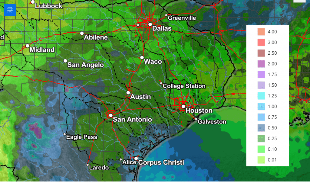
Rain amounts Sunday through Monday are forecast to generally average close to a half inch across most of the region. Slightly higher totals will be possible across the western Hill Country. In addition, some isolated totals of 1-2 inches cannot be ruled out.
NWS Rainfall Forecast Valid through Monday at 7 pm:
The cold front is expected to bring a noticeable change in the temperature over the weekend and early next week.
- High temperatures Saturday and Sunday will range from the low 80s across the northern Hill Country, to the upper 80s across Central Texas, to the low 90s across the coastal plains
- High temperatures Monday are forecast to be around 88-90 degrees
The chance for rain is forecast to diminish Monday afternoon. This will be followed by a pattern of sunny and less-hot weather next Tuesday through Friday. Daily high temperatures are forecast to be in the low and mid-90s. Lows will range from the mid-60s across the Hill Country, to around 70 degrees near the coast.
Similar conditions are forecast next weekend. No additional rain is forecast until just beyond the middle of the month.
Tropical Weather Outlook
The National Hurricane Center notes shower and thunderstorm activity is currently limited and disorganized in association with a tropical wave over the central tropical Atlantic. Although upper-level winds are generally favorable for development, environmental dry air is likely to limit development over the next couple of days. However, a tropical depression could still form early next week as the system moves westward at around 10 mph across the central tropical Atlantic. This system is likely to be near the Lesser Antilles by the middle to latter part of next week. NHC forecasters are giving this system a 70 percent chance for tropical development.
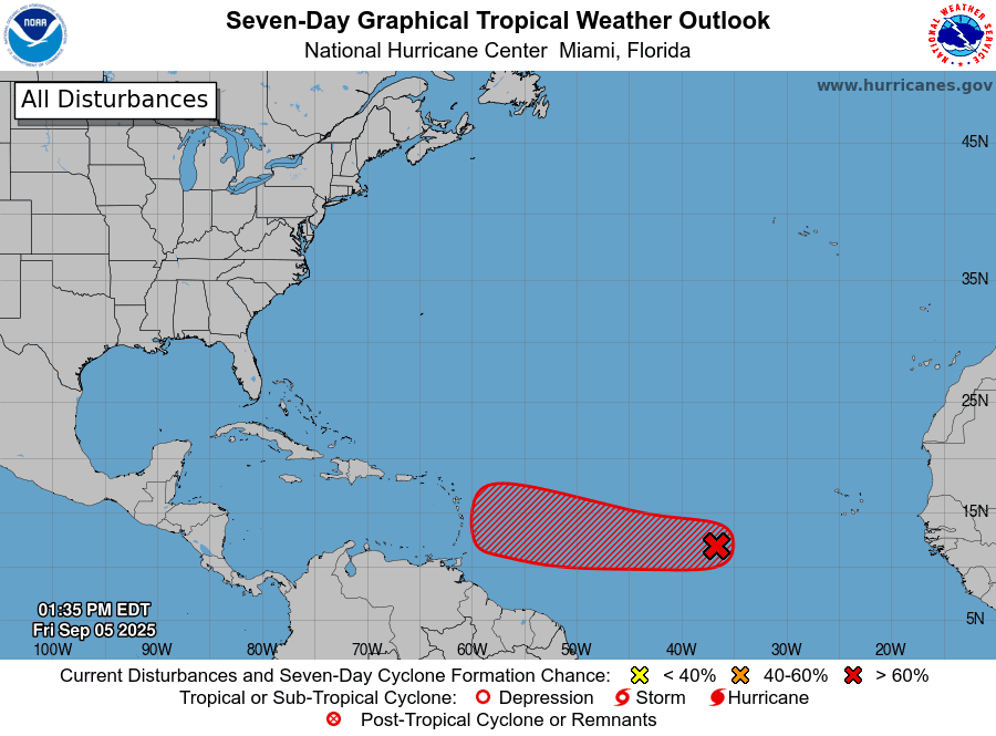
I will point out the latest runs of the GFS and European forecast models have essentially dropped development of this system due to too much dry surrounding the wave. However, it will need to be watched closely.
Elsewhere, there are no systems in place which pose a threat for tropical development over the next few days.
Have a great weekend!
Bob
For the latest weather information and forecasts, check out the National Weather Service:
Social Media