A Chance for Rain and Storms will Continue through Late Week
May 27, 2025
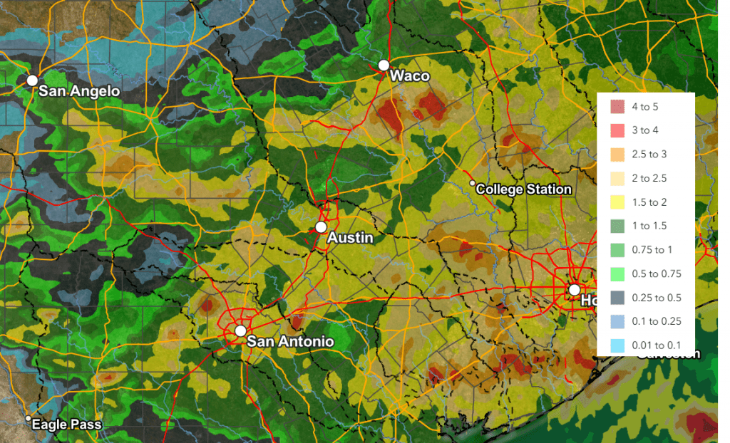
Storms moving across the area Monday afternoon and Monday night brought widespread heavy rain, strong winds, and some pockets of very large hail. LCRA’s Hydromet and Doppler radar estimates show the storm produced general totals of 1-2 inches across the eastern Hill Country, Central Texas, and the middle Texas coast. Some pockets of 2-2.5 inches occurred across the Hill Country between Menard and Kingsland, and also across parts of Wharton County. LCRA’s highest gauged 24-hour total was 2.94 inches, at a location in northern Gillespie County.
NWS Estimate of Rain Falling Between 7 am Monday and 7 am Tuesday:
The wave of low pressure partially responsible for Monday night’s storms has exited to the east. Tuesday afternoon’s weather is predicted to be mostly sunny. High temperatures will range from the mid-80s across the Hill Country, to the low 90s near the coast.
Another wave of rain and thunderstorms is forecast to develop late this afternoon and spread across the region late Tuesday evening and Tuesday night. A trough of low pressure currently located over northern Mexico is forecast to track northeast into Texas enhancing the development of thunderstorms. The atmosphere across West and Southwest Texas, along with northeastern Mexico is predicted to become moderately unstable by late afternoon and is expected to cause the development of an area of strong to severe thunderstorms across northeastern Mexico and Far West Texas late this afternoon. This activity is forecast to move to the east and southeast through the mid and late evening hours. This will take the storms across the southern Edwards Plateau and into the Hill Country, and possibly over portions of the Interstate 35 corridor. Unlike Monday’s night’s storms, it’s not clear how far east these next storms will move.
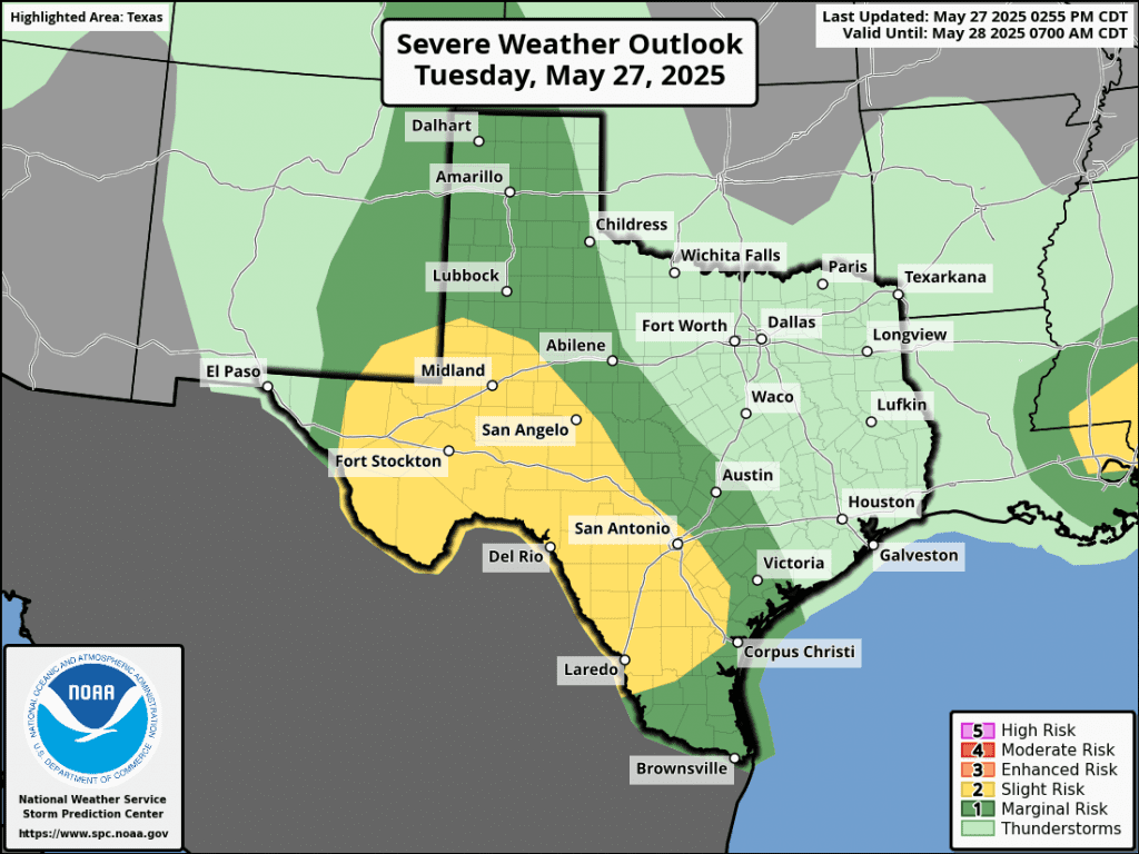
The atmosphere is forecast to be supportive for some of these storms to become strong to severe. The Storm Prediction Center has placed the western and southern Hill Country under a Slight Risk for severe thunderstorms through early Wednesday morning. The eastern Hill Country and the area between Austin and Victoria has been placed under a Marginal Risk for severe storms. The primary severe weather threats will be large to very large hail and damaging wind gusts. A secondary threat of an isolated tornado or two cannot be ruled out. In addition, we could also see some pockets of intense rainfall. Rainfall from these storms is forecast to generally average around 1-1.5 inches, with isolated heavier totals.
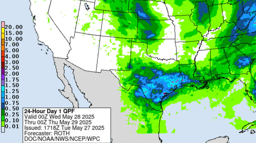
NWS Rainfall Forecast for the Period 7 pm Tuesday through 7 pm Wednesday:
Tuesday night’s storms are forecast to push off to the east Wednesday morning. Wednesday will feature a partly cloudy sky. Abundant moisture and lingering instability will yield a 40 percent chance for scattered afternoon and evening showers and thunderstorms. Expect high temperatures in the upper 80s to 90 degrees.
Additional scattered afternoon and evening showers and thunderstorms are forecast Thursday. The probability for rain will be near 50 percent. Thursday’s activity is not expected to be as widespread over as heavy as what is forecast for Tuesday night. Rain amounts are forecast to average around a quarter inch.
Additional periods of showers and thunderstorms are forecast Friday into Friday night as a weak cold front pushes south across the area. Rain amounts are forecast to only average around a quarter inch, or less.
The outlook for the weekend calls for generally dry weather as drier and more stable air spreads in behind Friday’s cold front. Expect high temperatures in the upper 80s to low 90s.
Looking ahead to next week, forecasts call for generally dry weather Monday, followed by a chance for showers and thunderstorms next Tuesday and Wednesday. Rain amounts are not expected to be very heavy. Dry and sunny weather will follow next Thursday and Friday. High temperatures next week are predicted to generally be in the mid-90s.
Tropical Weather Outlook
Weather conditions remain quiet across the tropical Atlantic and tropical cyclone development is not expected over the next seven days.
Have a good week!
Bob
Social Media