A very typical summertime weather pattern will remain across Texas as we close out the week and head into the weekend. However, the pattern is forecast to change beginning Sunday as high pressure over Texas weakens. At the same time, an area of tropical moisture is forecast to begin spreading inland from the western Gulf of Mexico while a weak cold front sags south out of the southern Plains. Both features are expected to bring an increasing chance for rain showers and scattered thunderstorms to the region beginning Sunday afternoon, with a continued chance for showers and scattered thunderstorms through mid-week. Widespread clouds and periods of rain should help keep next week’s high temperatures generally in the low 90s. Despite the lower temperatures, humidity levels are expected to stay quite high.
This afternoon through Saturday, weather conditions are forecast to be mostly sunny, breezy and hot. There will be a slight chance for a few isolated rain showers across the coastal region, but most other locations should stay dry. High temperatures both days will be in the mid and upper 90s across the Hill Country and Central Texas regions and in the low to mid-90s across the coastal plains. Afternoon peak heat index values are forecast to be in the range of 100-108 degrees. Expect a south breeze at 10-15 mph, with occasional gusts to 25 mph.
The weather pattern will begin to change Sunday as the area of tropical moisture begins spreading inland. Forecasts call for a 40-50 percent chance for scattered rain showers and thunderstorms across the Hill Country and Central Texas regions by afternoon. Across the coastal plains, scattered showers and thunderstorms are forecast to begin Sunday morning, with scattered activity continuing Sunday afternoon. The probability for rain will be near 60 percent. Expect a partly to mostly cloudy sky with high temperatures in the low 90s. Rain amounts Sunday are predicted to generally average between a quarter and an half inch.
Forecasts call for the active weather pattern to continue Monday through Friday as a broad trough of low pressure persists over the central and eastern U.S. Ridges of high pressure are forecast to hold in place just off the East Coast and over the northwestern U.S. With tropical moisture lingering across the area and occasional waves of low pressure rotating around the upper trough, periods of showers and thunderstorms are forecast each day across the region. The probability for rain will be near 50 percent Monday through Wednesday, decreasing to near 30 percent Thursday and Friday. Totals are forecast to generally average between a quarter and a half inch each day Monday through Wednesday. Totals Thursday and Friday are forecast to average close to a quarter inch or less per day.
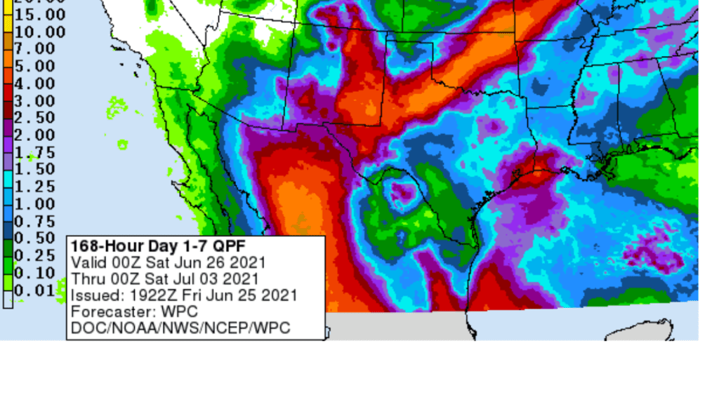
NWS 7-day totals over the period between this afternoon and next Friday morning are forecast to generally average between 1 and 1.5 inches across the entire region.
NWS Rainfall Forecast for the Period 7 pm Friday through 7 pm next Friday:
The risk for severe thunderstorms next week appears low.
With more clouds and scattered rain around the area next week, high temperatures next week are forecast to generally be in the low 90s.
Looking out to the Fourth of July weekend, forecasts call for ridges of high pressure to remain across the western and eastern U.S., with a trough of low pressure through middle of the country. The trough is expected to cause more scattered showers and thunderstorms across the region Saturday through Monday. It won’t be a total rainout by any means, but more scattered showers can be expected, with high temperatures in the low to mid-90s. There are indications a drier and warmer pattern will try to resume around July 7th.
Tropical Weather Outlook
Weather conditions are currently quiet across the Gulf of Mexico and Caribbean Sea.
However, National Hurricane Center forecasters are monitoring an area of disorganized showers and thunderstorms over the far eastern Atlantic, to the south of Cabo Verde Islands. These showers are associated with a strong tropical wave that is expected to move westward to west-northwestward at 15 to 20 mph across the tropical eastern and central Atlantic through the middle of next week. Development, if any, of this system should be slow to occur during the next several days due to marginally conducive environmental conditions. NHC forecasters are giving this system just a low chance (20 percent chance) for tropical development over the next 5 days.
Elsewhere, tropical cyclone development is not expected over the next 5 days.
Catch Venus and Mars in the Evening Sunset Sky
Venus (magnitude –3.8) shines low in the west-northwest sky during twilight. Tiny Mars, nearly 200 times fainter at magnitude +1.8, is closing in on Venus from the upper left. They’re separated by 10° from each other on June 25th, shrinking to 6° by July 2nd. Both set before twilight ends. They’ll be in conjunction, ½° apart, on July 12th and 13th.
If you missed Thursday night’s spectacular Strawberry Supermoon or you’d like to see it again, you’re in luck. A very bright, nearly full Moon will also be visible Friday night and it will appear very much like Thursday night’s moon. However, moonrise Friday night will be an hour later—about 10 pm CDT.
Have a good weekend.
Bob
Social Media