A Chance for Rain Wednesday through the Upcoming Weekend
April 28, 2025
We’ll be looking at a fairly typical late April/early May weather pattern this week with chances for rain showers and scattered thunderstorms for the middle and latter parts of the week, continuing through the weekend. Warm and humid conditions will be in place throughout the week.
A partly to mostly cloudy sky will be in place Monday afternoon as considerable moisture spreads inland from the Gulf. The atmosphere will be too stable to allow for the development of showers and thunderstorms. Expect high temperatures to generally be in the mid-80s.
Forecasters are closely monitoring the area along and just to the west of the Rio Grande river where the dry line is in place. High resolution forecasts call for scattered thunderstorms to develop along the dry line between Del Rio and Eagle Pass late this afternoon, with the thunderstorms moving to the east-northeast. Should these storms hold together, there is 20-30 percent chance they could spread east across the Edwards Plateau and over parts of the Hill Country as far east as Fredericksburg Monday evening. Some of these storms could be strong to severe. All of the thunderstorms are forecast to diminish by late Monday evening.
Tuesday’s weather is forecast to be very similar to Monday. Widespread morning clouds should give way to a partly to mostly cloudy sky in the afternoon. Expect high temperatures again to be in the upper 80s. Forecasts indicate a few scattered thunderstorms may develop along the dry line out close to the Rio Grande Tuesday afternoon, but these storms are expected to diminish before reaching the Hill Country. A separate area of thunderstorms is predicted to develop across West Texas Tuesday evening. This area of storms is forecast to move east-southeast and could move across the northern Hill Country after midnight Tuesday night. Some of these storms could be strong to severe, producing damaging winds and large hail. Rain amounts of 0.25-0.5 inches will be possible.
The most favorable period for rain and thunderstorms this week is forecast to occur Wednesday afternoon into Wednesday night when a trough of low pressure tracks from New Mexico, northeast across the Texas Panhandle. The trough is expected to push the dry line out of West Texas and into the Hill Country by Wednesday afternoon. Forecasts call for showers and scattered thunderstorms to develop along the dry line and spread to the east Wednesday afternoon and evening. In addition, scattered air mass thunderstorms will be possible out ahead of the dry line Wednesday as the atmosphere becomes increasingly unstable.
The probability for rain and thunderstorms Wednesday is forecast to be near 70-80 percent across the Hill Country and Central Texas regions, but only near 20 percent near the coast. The probability for rain will decrease to around 40 percent across the Hill Country and Central Texas Wednesday evening. Towards the coast, the chance for rain and storms will increase to 40 percent Wednesday evening.
Rain amounts Wednesday through Wednesday night are predicted to average around a half inch across the Hill Country and Central Texas regions, and around a quarter inch across the coastal plains. Isolated heavier totals will be possible—especially across the northern counties of Central Texas and the Hill Country.
Thursday’s weather is shaping up to be mostly sunny and warm. There will be just a 20 percent chance for a few scattered rain showers and isolated thunderstorms. Expect high temperatures to be around 90 degrees.
The chance for rain showers and isolated thunderstorms will increase across the region Friday and continue through the weekend as a Pacific cold front sinks to the south and pulls up stationary along the Gulf coast. At the same time, some weak disturbances are forecast to spread over Texas out of northern Mexico during the same period. There may be a threat for some strong to severe storms on Friday. Forecasts call for a 50 percent chance for rain Friday and Friday night, near 40 percent for Saturday and 30 percent for Sunday. Rain amounts Friday through Sunday evening are forecast to generally average between 0.5 and 1 inch across the Hill Country and Central Texas regions, and around a half inch across the coastal plains. Isolated heavier totals will be possible.
High temperatures Friday and through the weekend are predicted to be in the mid-80s.
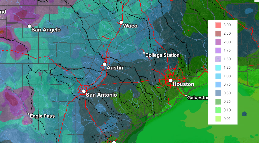
National Weather Service Cumulative rain totals over the next seven days call for amounts of 0.5-1.5 inches across the Hill Country and Central Texas regions, and close to a half inch across the middle Texas coast.
NWS Rainfall Forecast for the Period 6 pm Monday through 6 pm Next Monday:
Looking into next week, forecasts call for an unsettled weather pattern to continue. An active dry line is expected the first half of the week, which could bring rounds of strong to severe storms. A more widespread rain with scattered thunderstorms is expected for the second half of next week. High temperatures next week are forecast to be mostly in the mid-80s.
Have a good week!
Bob
Social Media