It was a picture-perfect weekend, with cool nights, pleasant daytime temperatures and low humidity levels. This pattern will continue as we start off the new week, but numerous changes in the weather look to take place mid-week that will bring our region widespread rain showers, followed by the coolest temperatures so far this autumn.
Monday’s weather maps showed stable and quiet weather conditions in place across much of Texas. Up to our north, a Canadian cold front stretches east-to-west across North Texas, close to Interstate 20. The front pushed south of the Red River Sunday afternoon but has since pulled up stationary. Temperatures north of the boundary were in the 40s and 50s. But the front has lost its momentum to push further south for the time being, and mild to warm temperatures will continue this afternoon into Tuesday. This afternoon’s weather will feature a mostly sunny sky, with temperatures climbing close to 78-80 degrees. Expect a light southeasterly wind at 5-10 mph. Monday night, clouds will increase and the sky is forecast to become overcast after midnight. Lows Tuesday morning will be in the mid-50s.
On Tuesday, we will begin to see a change in the weather pattern as a trough of low pressure tracking southeast out of the southern Rockies helps to give the stalled front across North Texas a slow shove to the south. Tuesday’s weather will include morning clouds and a partly cloudy afternoon. High temperatures will be in the mid and upper 70s. Forecasts call for the cold front to push through the Concho Valley and the Heartland Tuesday afternoon, with the front moving into the northern Hill Country Tuesday evening. The front is predicted to move through the Austin area after sunrise Wednesday and continue moving south to the coast Wednesday afternoon.
An area of light rain and drizzle is forecast to develop along the cold front itself, with a widespread rain showers and isolated thunderstorms occurring behind the cold front Wednesday through Wednesday night. The rain is predicted to end from west to east Thursday morning. Strong or severe thunderstorms are not expected as the wave of low pressure moves across the state Wednesday. Rain amounts between Tuesday night and midday Thursday are forecast to generally average between 1 and 1.25 inches across the eastern Hill Country, Central Texas and coastal regions. Lower totals are predicted for the western Hill Country and the Edwards Plateau.
NWS Rainfall Forecast for the Period 7 pm Monday through 7 pm Thursday:
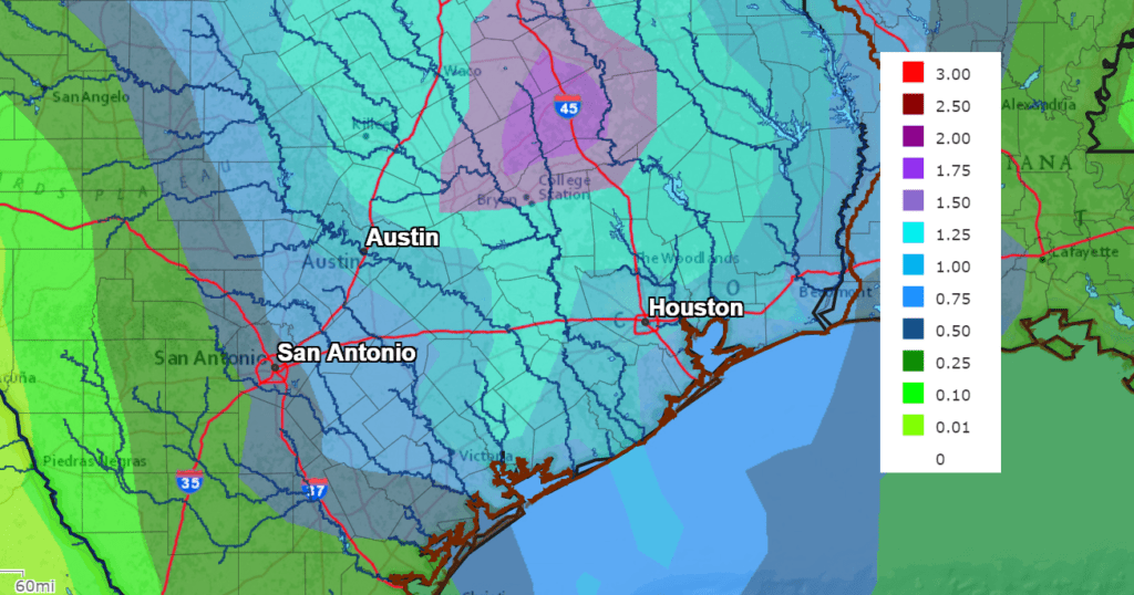
Temperatures will trend much cooler behind the cold front beginning Wednesday into Wednesday night. High temperatures Wednesday are forecast to be in the mid-60s across the Hill Country, in the upper 60s to low 70s across Central Texas and in the mid-70s towards the coast. Lows Thursday morning will include the mid-40s across the Hill Country, the upper 40s across Central Texas and the low 50s across the coastal plains.
On Thursday, the chance for rain will end from west to east in the morning. The sky is forecast to become partly cloudy in the afternoon. Breezy and much cooler weather will be in place! High temperatures will include the mid-50s across the Hill Country, with upper 50s at most other locations. Lows Friday morning will include the mid and upper 30s across the Hill Country, be near 40-42 degrees across Central Texas, with low to mid-40s expected towards the coast.
Sunny weather is forecast Friday through Sunday as a weak ridge of high pressure strengthens across Texas. We will see a slow warming trend as winds turn out of the southeast over the weekend.
- High temperatures will be in the low 60s Friday, warming the upper 60s Saturday and to near 70 degrees Sunday.
- Lows Saturday morning will be near 40-42 degrees. Lows Sunday morning are predicted to be in the mid-40s. Lows Monday morning will be near 50-52 degrees.
The outlook for next week calls for mostly sunny and mild weather Monday through Wednesday, with highs warming through 70s. Lows will be in the 50s. A Canadian cold front is predicted to push through the area sometime next Thursday. A few showers are expected with the cold front. Sunny and cooler weather will follow the cold front, with highs dropping back to near 70 degrees, with low temperatures in the upper 40s.
Tropical Weather Outlook
The large area of low pressure which moved up the East Coast last week moved out over the Atlantic and became entangled with a cold front over the weekend. The area of low pressure began to acquire some tropical characteristics and has since been designated Subtropical Storm Wanda. As of 10 am CDT, the center of Subtropical Storm Wanda was located over the central north Atlantic, roughly 935 miles west-southwest of the Azores. The storm is moving toward the east near 6 mph and this general motion should continue this morning. A turn toward the northeast is expected by tonight, followed by a turn toward the north by late Tuesday. Maximum sustained winds have decreased to near 45 mph with higher gusts. Some slight fluctuations in strength are anticipated during the next few days. However, Wanda could still become a tropical storm on Tuesday.
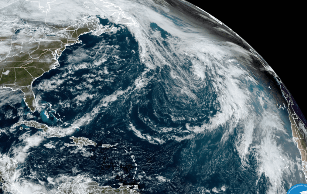
NOAA/Colorado State University/RAMMB 11/01/21 12:20 pm CDT
National Hurricane Center forecasters are monitoring an area of low pressure system which has formed over the southwestern Caribbean Sea just north of western Panama. This system is expected to move westward into Central America by early Tuesday, which will inhibit tropical cyclone development. However, this disturbance will still produce locally heavy rainfall across southern Nicaragua, Costa Rica, and Panama through Tuesday, which could result in flooding and mudslides. By Wednesday, the system will move into the far eastern portion of the Eastern Pacific basin. NHC forecasters are giving this system a low chance, a 10 percent chance, for tropical development over the next 5 days.
Out across the eastern tropical Atlantic, a small low pressure system located several hundred miles west of the Cabo Verde Islands has become better defined today. However, associated shower activity is limited, and the system is expected to continue moving northwestward into a region of less conducive upper-level winds. These factors should limit the chance for tropical cyclone formation. NHC forecasters are giving this system a low chance, a 10 percent chance, for tropical development over the next 5 days.
October Climate
Temperatures averaged well above normal across all of Texas during October, with most readings averaging between 2 and 4 degrees above normal. IN Austin, Camp Mabry’s temperature averaged 74.3 degrees, which was 2.7 degrees above normal. October 2021 tied with 1941 for the 9th warmest October on record. At Austin-Bergstrom, the temperature average 71.4 degrees, which was 1.5 degrees above normal. October 2021 tied with 1974 for the 25th warmest October on record.
October Rainfall average below normal across the Hill Country and the middle Texas coast, but was between 1 and 3 inches above normal across most of Central Texas. In Austin, rainfall of 5.30 inches ranks as the 29th wettest October on record. At Austin-Bergstrom, rainfall of 5.59 inches ranks as the 17thg wettest October on record.
Time Change Weekend Coming Up
Daylight Saving time will end this coming Sunday, November 7th at 2:00 am. At that time, we will “fall back”, turning our clocks back one hour, as we move back to Central Standard Time.
Have a good week.
Bob
Social Media