Some changes to our persistent hot and dry weather pattern are expected over the next week as the stagnant ridge of high pressure over Texas weakens, allowing tropical moisture to spread inland from the Gulf of Mexico. With a less stable atmosphere and abundant moisture, forecasts call for a slight chance for rain across the entire region each afternoon, through late next week. Although significant totals of rain are not expected, a few locations could see amounts up to a couple of inches—especially late in the week.
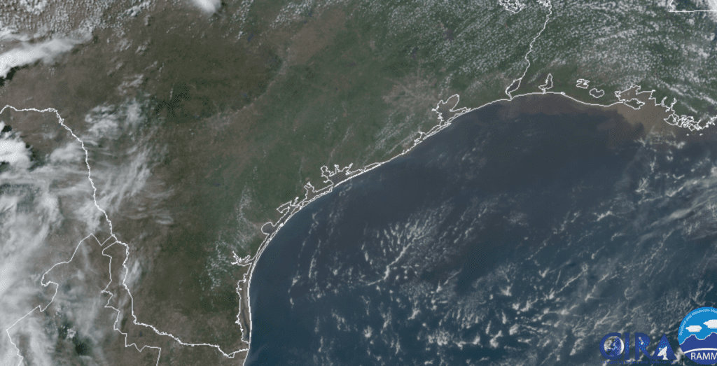
Atmospheric observations from Friday morning showed a plume of enhanced moisture spreading northwest from the Texas coast. Weather radar at midday showed scattered rain showers and isolated thunderstorms dotting the coastal plains from Houston to the Rio Grande Valley, with all of the activity spreading to the west and northwest. The plume of moisture will bring a chance for scattered rain showers and isolated thunderstorms to most of Central Texas and the eastern Hill Country this afternoon and early evening. The probability for rain will range from near 20 percent across the Hill Country to 30 percent across Central Texas to near 40 percent across the coastal plains. Rain amounts are forecast to average less than a quarter inch, with a couple of isolated totals to a half inch possible. Today’s scattered showers are forecast to diminish around sunset as temperatures cool. High temperatures this afternoon will generally be in the low 90s. Expect a southeasterly breeze at 10-15 mph.
Today’s plume of enhanced moisture is forecast to exit to the west on Saturday. However, enough moisture will still be in place to cause a few spotty afternoon rain showers and isolated thunderstorms across the Austin/Central Texas and coastal regions. The probability for rain will be less than 20 percent. Rain amounts, if any, should total less than a quarter inch. Under a most sunny sky, Saturday’s temperature is predicted to reach the low and mid-90s.
Sunday through next Tuesday, forecasts call for a broad, weak area of low pressure to develop over much of Texas as the high pressure ridge splits; shifting to the Desert Southwestern U.S. and the eastern Gulf of Mexico. The combination of an slightly unstable atmosphere and abundant tropical moisture is expected to cause a few scattered rain showers and thunderstorms mainly across the Central Texas and coastal regions each afternoon and evening. The probability for rain will be near 20 percent across Central Texas and near 30-40 percent across the coastal plains region. Daily rain amounts should average less than a quarter inch. Daily high temperatures are forecast to be in the low and mid-90s.
Forecasts are showing an increased chance for rain and thunderstorms taking shape across our region next Wednesday through Friday as the area of low pressure over Texas sinks to the south. The circulation around the trough is expected to bring considerable moisture north from the Gulf of Mexico, creating a favorable pattern for the development of rain showers all three days. Periods of rain and thunderstorms are forecast. The rainy pattern is predicted to diminish late Friday as the low lifts off to the northeast. The probability for rain will be highest across the coastal plains. Rain amounts over the 3-day period are currently forecast to average around 1 inch, with isolated higher totals. Depending on how this low sets up, totals to near 2 inches will be possible. High temperatures through the period are forecast to be near 90-92 degrees.
A drier and warmer pattern is forecast beginning next weekend, continuing through early July as a weak ridge of high pressure becomes reestablished across Texas. Forecast solutions indicate the ridge is not going to be all that strong. This will allow more scattered afternoon showers across the coastal plains region. Generally dry weather is forecast across the Hill Country and Central Texas regions. High temperature are forecast to hold mostly in the middle 90s.
Tropical Weather Outlook
Weather conditions are quiet across the tropical Atlantic, the Caribbean Sea and the Gulf of Mexico. There are no systems in place which pose a threat for development over the next 5 days.
Forecasters are monitoring an unusually large plume of Saharan dust that is currently spreading west across the tropical Atlantic along the trade winds. Some of this dust may affect parts of Texas by the middle of next week.
RAMMB-CIRA 06/19/20 12:10 pm CDT
Summer Solstice 2020
The summer solstice arrives Saturday at 4:44 pm CDT. This is when the Sun reaches its northernmost declination in Earth’s sky and begins its six-month return southward. Summer begins in the Northern Hemisphere, winter in the Southern Hemisphere. In Austin, the midday sun will reach 83 degrees above the horizon. For folks in the Northern Hemisphere, Saturday this will be the longest day and the shortest night of the year. Austin’s day length will be 14 hours and 6 minutes!
Here’s a natural phenomenon you might never have imagined. The sun actually takes more time to set around the time of a solstice. It’s true. The longest sunsets (and sunrises) occur at or near the solstices. The shortest sunsets (and sunrises) occur at or near the equinoxes. As viewed from both the Northern and Southern Hemispheres, the sun rises and sets farthest north at the June solstice and farthest south at the December solstice. Now consider that the farther the sun sets from due west along the horizon, the shallower the angle of the setting sun. That means a longer duration for sunset at the solstices. Meanwhile, at an equinox, the sun rises due east and sets due west. That means – on the day of an equinox – the setting sun hits the horizon at its steepest possible angle, resulting in shorter sunrises and sunsets. (earthsky.org)
Have a good Father’s Day Weekend!
Bob
Social Media