A Daily Slight Chance for Rain Looks to Continue Next Week
May 30, 2025
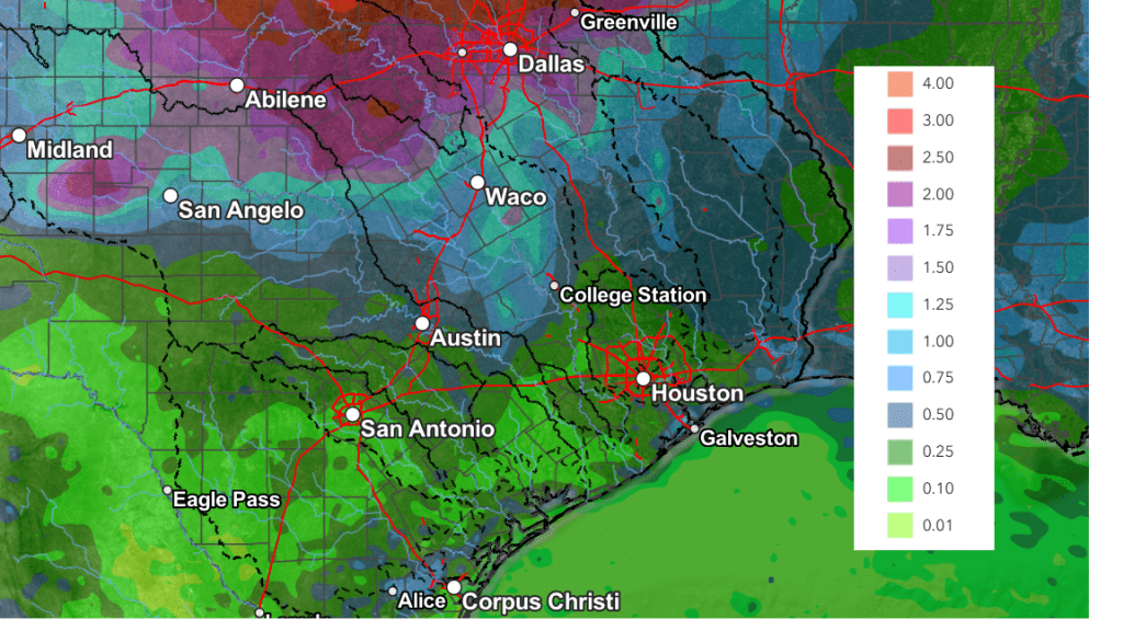
A complex of rain showers and thunderstorms originating across Northwest Texas, pushed southeast through the Hill Country, Central Texas, and coastal regions late Thursday night into Friday morning. Fortunately, there were no reports of hail or high winds as the storms moved across the area. But the storms did bring another round of much need rain. According to LCRA’s Hydromet as of noon, totals across the Hill Country and the Austin/Travis County area generally averaged between 0.5 and 1.5 inches. To the east of Austin, totals between Bastrop and Columbus generally averaged between a third and a half inch. To the south of Interstate 10, totals were a bit higher, ranging between 1 and 1.5 inches. LCRA’s gauge located at Glen Flora, in central Wharton County, recorded a total of 3.37 inches.
Thursday night’s storms developed as a wave of low pressure pushed east out of New Mexico sparking the development of showers and thunderstorms along a southward-moving cold front over the Texas South Plains. The storms and the cold front both tracked to the southeast overnight. As of late Friday morning, the storms were exiting the middle Texas coast while the cold front stretched across Central Texas. Forecasts call for the cold front to continue moving southeast Friday afternoon, pushing off the coast Friday evening. The front is expected to bring slightly cooler temperatures Friday through Saturday.
- High temperatures Friday will range from around 80 degrees across the northern Hill Country, to the mid-80s across the coastal plains
- Lows Saturday morning will include the mid-60s across the Hill Country, the upper 60s across Central Texas, and the low 70s coastal plains
- High temperatures Saturday are forecast to be in the mid and upper 80s
- Lows Sunday morning will be in the upper 60s to low 70s
Lingering moisture behind the cold front is expected to create a mostly cloudy sky Friday afternoon and Friday night. The clouds should give way to a mostly sunny sky on Saturday and Sunday.
There will be a slight chance for scattered rain showers and thunderstorms across the region Sunday afternoon and through all of next week. Despite a weak ridge of high pressure setting up over the southern Plains for the first half of next week, forecasts also call for a series of weak waves of low pressure to track across Texas out of the southern Rockies. This will be a somewhat different setup from what we’ve experienced this week. It is expected to keeping the heaviest rains across Oklahoma and the northern third of Texas.
On Sunday, forecasts call for a complex of showers and thunderstorms to develop across Oklahoma and track southeast across the eastern half of Texas in the afternoon. Some of the showers may extend as far west as Austin and Interstate 35. The probability for rain will only be at 20 percent.
Next week, the attention will be on West Texas where approaching disturbances are expected to cause the development of scattered thunderstorms along the dry line. The storms are forecast to track to the east across the Hill Country, possibly reaching as the I-35 corridor. As of now, the probability for rain each day will only be 20 percent. Forecast solutions indicate a somewhat better chance for rain will occur Wednesday and Wednesday night when a weak cold front sags to the south. The probability for rain Wednesday will be near 40 percent.
NWS Rainfall Forecast for the Period 7 pm Friday through 7 pm Next Friday:
High temperatures next week are forecast to be mostly in the low and mid-90s. Lows are predicted to be in the mid-70s.
Looking out further into the second week of June, forecasts indicate the weather pattern will remain somewhat unsettled, with more chances for rain expected. High temperatures are forecast to be in the mid and upper 90s.
Tropical Weather Outlook
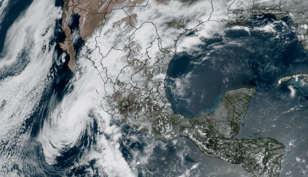
The Atlantic hurricane season will officially start this Sunday. Weather conditions are currently quiet across the tropical Atlantic, and tropical cyclone development is not expected over the next seven days.
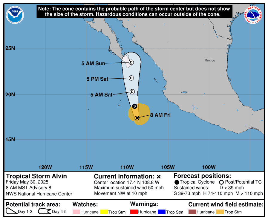
In the eastern tropical Pacific, Tropical Storm Alvin continues to churn about 385 miles south of the southern tip of Baja, California. Maximum sustained winds are near 50 mph) with higher gusts. However, weakening is forecast Friday night, and Alvin is expected to degenerate to a remnant low on Saturday as it tracks toward Baja.
NOAA/Colorado State University/RAMMB 05/30/2025 1:30 pm CDT
Have a great weekend!
Bob
Social Media